STS51C-143-27
| NASA Photo ID | STS51C-143-27 |
| Focal Length | 250mm |
| Date taken | 1985.01.__ |
| Time taken | GMT |
Resolutions offered for this image:
5248 x 4096 pixels 640 x 499 pixels 640 x 480 pixels 800 x 670 pixels
5248 x 4096 pixels 640 x 499 pixels 640 x 480 pixels 800 x 670 pixels
Cloud masks available for this image:
Spacecraft nadir point:
Photo center point: 29.5° N, 89.5° W
Photo center point by machine learning:
Photo center point: 29.5° N, 89.5° W
Photo center point by machine learning:
Nadir to Photo Center:
Spacecraft Altitude: nautical miles (0km)
Country or Geographic Name: | USA-LOUISIANA |
Features: | MISSISSIPPI DELTA |
| Features Found Using Machine Learning: | |
Cloud Cover Percentage: | 5 (1-10)% |
Sun Elevation Angle: | ° |
Sun Azimuth: | ° |
Camera: | Linhof |
Focal Length: | 250mm |
Camera Tilt: | Near Vertical |
Format: | 5017: Kodak, natural color positive, Ektachrome, X Professional, ASA 64, standard base |
Film Exposure: | Normal |
| Additional Information | |
| Width | Height | Annotated | Cropped | Purpose | Links |
|---|---|---|---|---|---|
| 5248 pixels | 4096 pixels | No | No | Earth From Space collection | Download Image |
| 640 pixels | 499 pixels | No | No | Earth From Space collection | Download Image |
| 640 pixels | 480 pixels | No | No | ISD 1 | Download Image |
| 800 pixels | 670 pixels | Download Image |
Download Packaged File
Download a Google Earth KML for this Image
View photo footprint information
Download a GeoTIFF for this photo
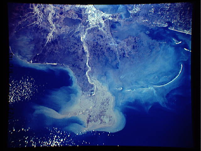
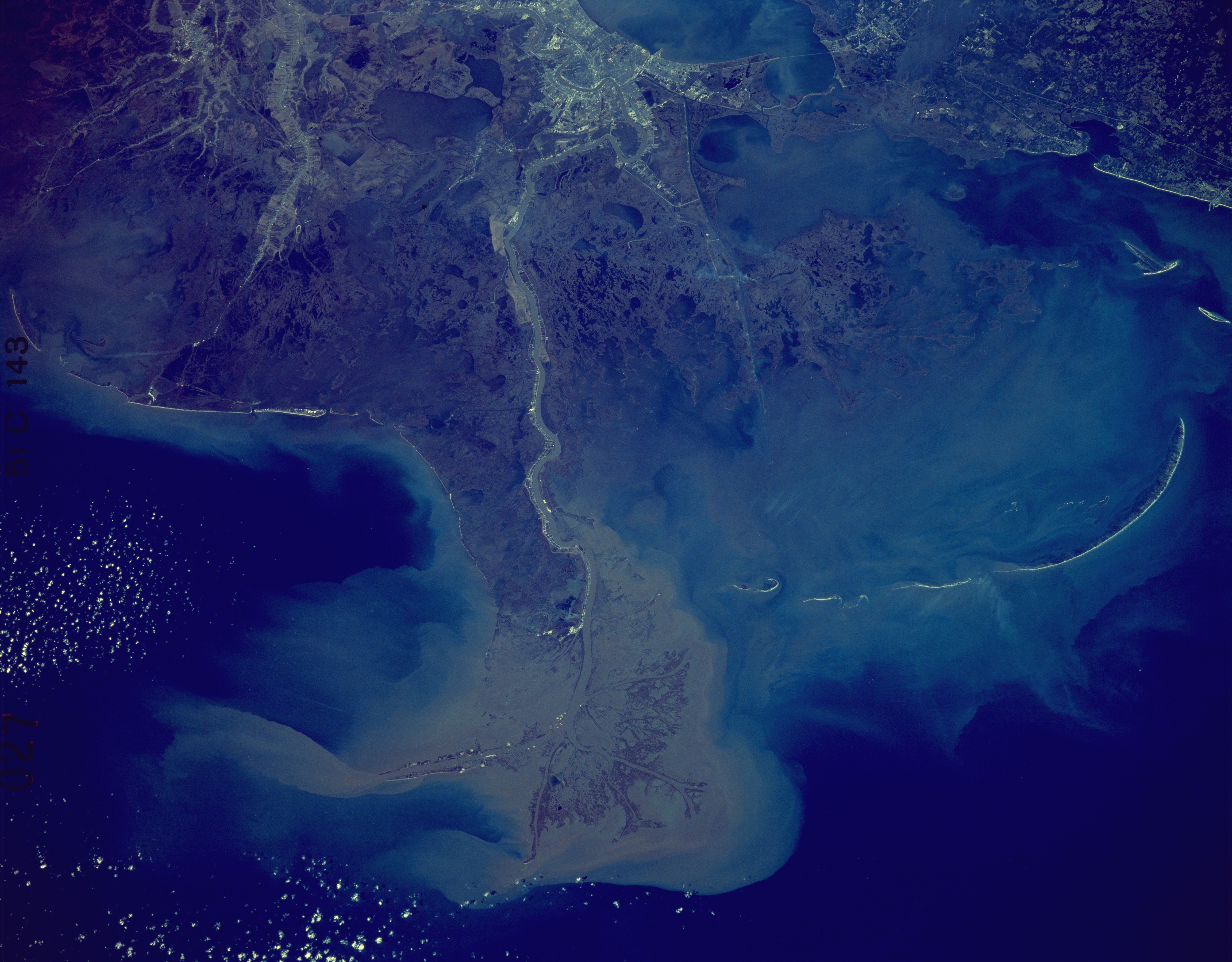
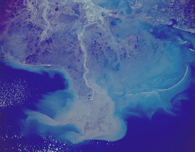
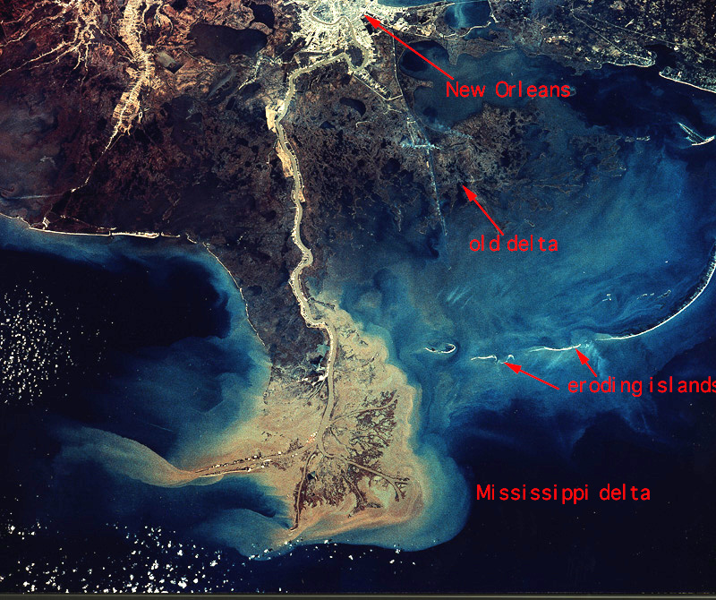
Image Caption: STS51C-143-0027 Mississippi River Delta and Coastal Louisiana, U.S.A. January 1985
This synoptic photograph of the north-central Gulf of Mexico shows southeastern Louisiana and the southwest coast of Mississippi. The three major features in this photograph are the Mississippi River, its delta, and the city of New Orleans located along the south side of Lake Pontchartrain (barely visible at the northern edge of the photograph). This photograph shows the effects of dynamic events, such as wind direction (note the smoke plumes southeast of New Orleans) and the sediment pattern caused by near-shore water currents around the mouth of the Mississippi River--the world's only "bird's foot" delta. The elongated, narrow strips of land parallel to the coastline are fragmented barrier islands--most notably the Chandeleur Islands. Close observation of the field patterns along the Mississippi River in Louisiana shows definite French influence. These rectangular farms, called "long lots," are laid out in sequence, perpendicular to the river, allowing each farm access to the waterways. Swamplands can be seen south of New Orleans.
This synoptic photograph of the north-central Gulf of Mexico shows southeastern Louisiana and the southwest coast of Mississippi. The three major features in this photograph are the Mississippi River, its delta, and the city of New Orleans located along the south side of Lake Pontchartrain (barely visible at the northern edge of the photograph). This photograph shows the effects of dynamic events, such as wind direction (note the smoke plumes southeast of New Orleans) and the sediment pattern caused by near-shore water currents around the mouth of the Mississippi River--the world's only "bird's foot" delta. The elongated, narrow strips of land parallel to the coastline are fragmented barrier islands--most notably the Chandeleur Islands. Close observation of the field patterns along the Mississippi River in Louisiana shows definite French influence. These rectangular farms, called "long lots," are laid out in sequence, perpendicular to the river, allowing each farm access to the waterways. Swamplands can be seen south of New Orleans.
