STS51C-143-26
| NASA Photo ID | STS51C-143-26 |
| Focal Length | 250mm |
| Date taken | 1985.01.__ |
| Time taken | GMT |
Resolutions offered for this image:
5565 x 4173 pixels 640 x 479 pixels 640 x 480 pixels 800 x 677 pixels
5565 x 4173 pixels 640 x 479 pixels 640 x 480 pixels 800 x 677 pixels

Cloud masks available for this image:
Spacecraft nadir point:
Photo center point: 30.5° N, 84.5° W
Photo center point by machine learning:
Photo center point: 30.5° N, 84.5° W
Photo center point by machine learning:
Nadir to Photo Center:
Spacecraft Altitude: nautical miles (0km)
Country or Geographic Name: | USA-FLORIDA |
Features: | TALLAHASSEE |
| Features Found Using Machine Learning: | |
Cloud Cover Percentage: | 0 (no clouds present) |
Sun Elevation Angle: | ° |
Sun Azimuth: | ° |
Camera: | Linhof |
Focal Length: | 250mm |
Camera Tilt: | Low Oblique |
Format: | 5017: Kodak, natural color positive, Ektachrome, X Professional, ASA 64, standard base |
Film Exposure: | Normal |
| Additional Information | |
| Width | Height | Annotated | Cropped | Purpose | Links |
|---|---|---|---|---|---|
| 5565 pixels | 4173 pixels | No | No | Earth From Space collection | Download Image |
| 640 pixels | 479 pixels | No | No | Earth From Space collection | Download Image |
| 640 pixels | 480 pixels | No | No | ISD 1 | Download Image |
| 800 pixels | 677 pixels | Yes | No | Download Image |
Download Packaged File
Download a Google Earth KML for this Image
View photo footprint information
Download a GeoTIFF for this photo
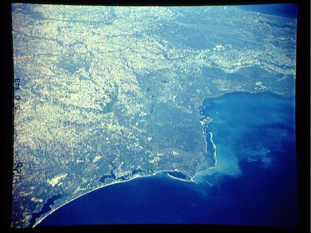
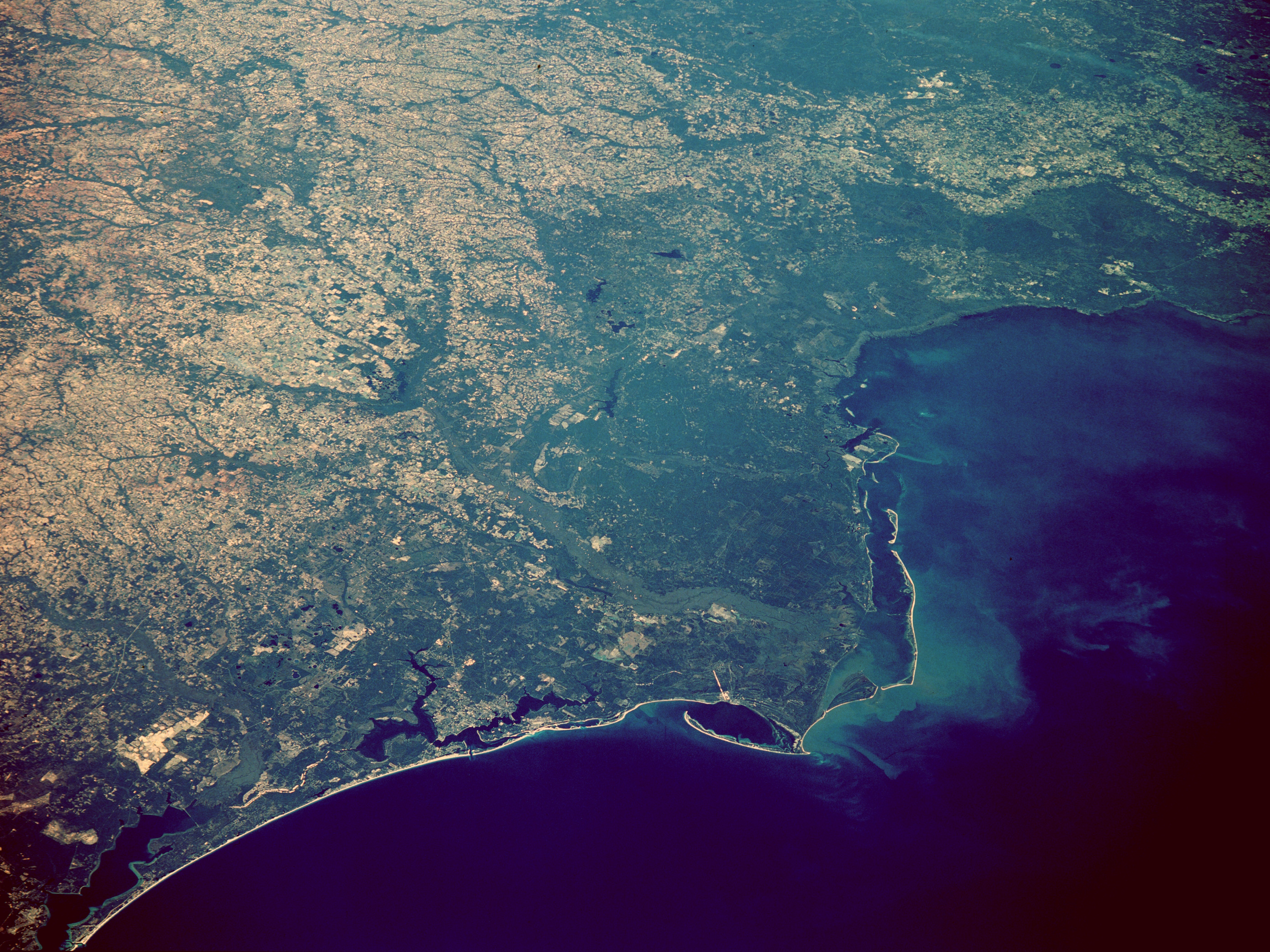
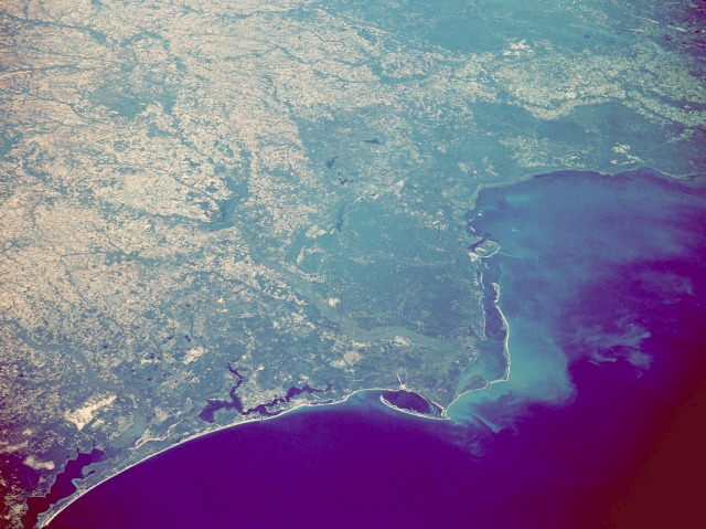
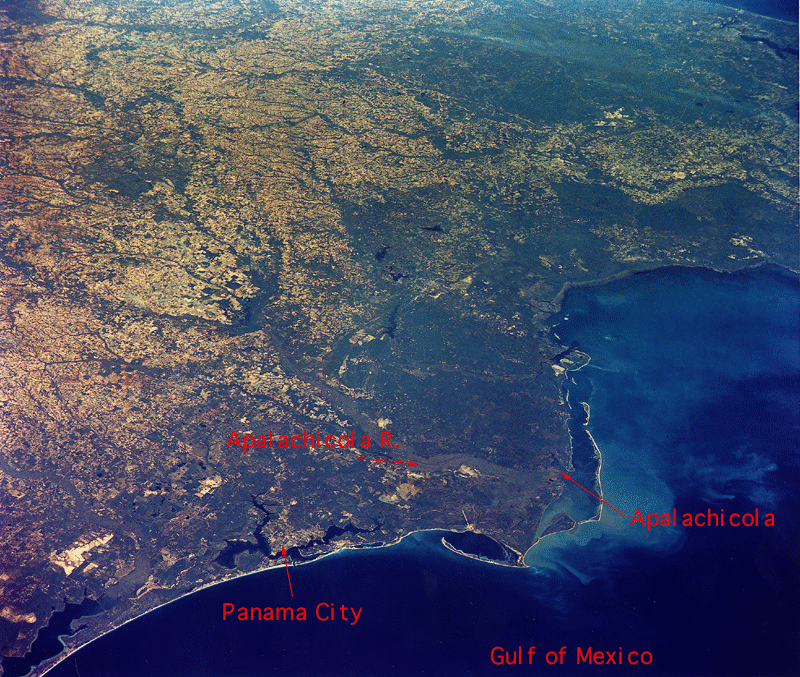
Image Caption: STS51C-143-0026 Apalachicola Basin, West Florida January 1985
The most obvious landform in this low-oblique, northeast-looking photograph is the Apalachicola River drainage basin that has formed a peninsular protrusion into the Gulf of Mexico. From its major sediment plume, the Apalachicola River and its gray floodplain can be traced north to Lake Seminole. This area--from the eastern end of Choctawhatchee Bay (western edge of photograph) to the St. Johns River and Jacksonville, Florida (eastern edge of photograph)--comprises the coastal plains of the southeastern United States. Among the features in the area are several barrier islands, including elongated St. George Island (visible immediately south of the mouth of the Apalachicola River) and Dog Island (farther to the east); the Apalachicola National Forest (heavily forested area east of the river); other forested areas indicated by darker green; and pasturelands and cultivated fields (lighter tans and yellows). Although no details are discernible for Tallahassee, the state capital, its approximate site can be determined by the location of the four dark lakes in the center of the photograph. The smoke plumes near the eastern edge of the photograph provide a clue to the clarity of this photograph--strong northerly surface winds reduce the humid air mass that sometimes affects this area.
The most obvious landform in this low-oblique, northeast-looking photograph is the Apalachicola River drainage basin that has formed a peninsular protrusion into the Gulf of Mexico. From its major sediment plume, the Apalachicola River and its gray floodplain can be traced north to Lake Seminole. This area--from the eastern end of Choctawhatchee Bay (western edge of photograph) to the St. Johns River and Jacksonville, Florida (eastern edge of photograph)--comprises the coastal plains of the southeastern United States. Among the features in the area are several barrier islands, including elongated St. George Island (visible immediately south of the mouth of the Apalachicola River) and Dog Island (farther to the east); the Apalachicola National Forest (heavily forested area east of the river); other forested areas indicated by darker green; and pasturelands and cultivated fields (lighter tans and yellows). Although no details are discernible for Tallahassee, the state capital, its approximate site can be determined by the location of the four dark lakes in the center of the photograph. The smoke plumes near the eastern edge of the photograph provide a clue to the clarity of this photograph--strong northerly surface winds reduce the humid air mass that sometimes affects this area.
