STS51B-31-81

| NASA Photo ID | STS51B-31-81 |
| Focal Length | 100mm |
| Date taken | 1985.04.30 |
| Time taken | 12:02:28 GMT |
Resolutions offered for this image:
3920 x 3946 pixels 635 x 639 pixels 5700 x 5900 pixels 500 x 518 pixels
3920 x 3946 pixels 635 x 639 pixels 5700 x 5900 pixels 500 x 518 pixels
Cloud masks available for this image:
Spacecraft nadir point: 44.6° N, 4.7° W
Photo center point: 43.0° N, 1.5° E
Photo center point by machine learning:
Photo center point: 43.0° N, 1.5° E
Photo center point by machine learning:
Nadir to Photo Center: East
Spacecraft Altitude: 194 nautical miles (359km)
Country or Geographic Name: | FRANCE |
Features: | PYRENEES |
| Features Found Using Machine Learning: | |
Cloud Cover Percentage: | 10 (1-10)% |
Sun Elevation Angle: | 60° |
Sun Azimuth: | 173° |
Camera: | Hasselblad |
Focal Length: | 100mm |
Camera Tilt: | Low Oblique |
Format: | 5017: Kodak, natural color positive, Ektachrome, X Professional, ASA 64, standard base |
Film Exposure: | Normal |
| Additional Information | |
| Width | Height | Annotated | Cropped | Purpose | Links |
|---|---|---|---|---|---|
| 3920 pixels | 3946 pixels | No | No | Earth From Space collection | Download Image |
| 635 pixels | 639 pixels | No | No | Earth From Space collection | Download Image |
| 5700 pixels | 5900 pixels | No | No | Download Image | |
| 500 pixels | 518 pixels | No | No | Download Image |
Download Packaged File
Download a Google Earth KML for this Image
View photo footprint information
Download a GeoTIFF for this photo
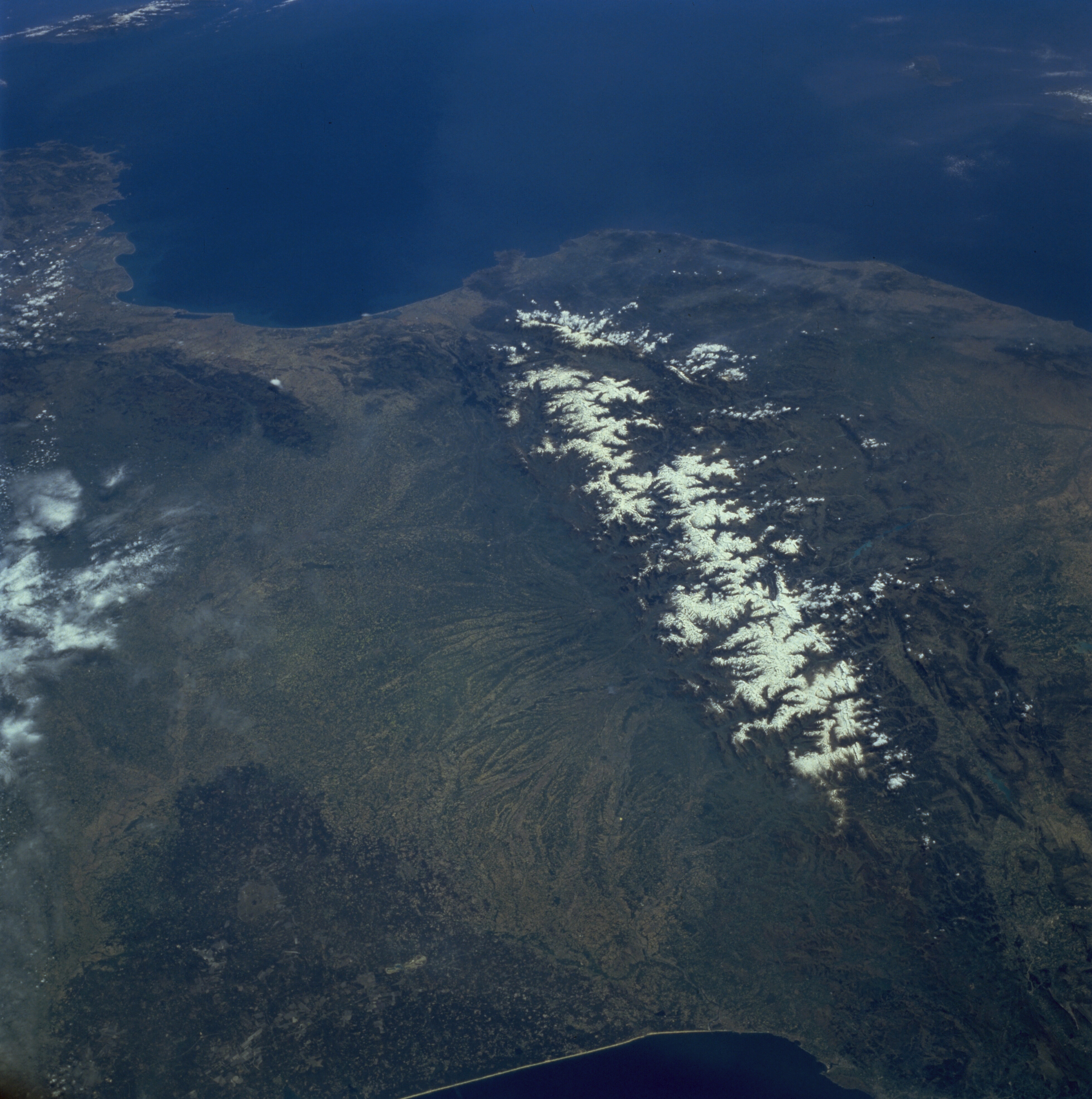
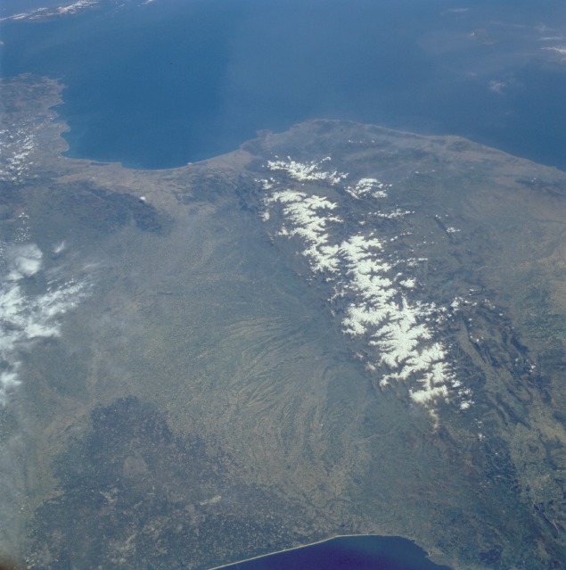
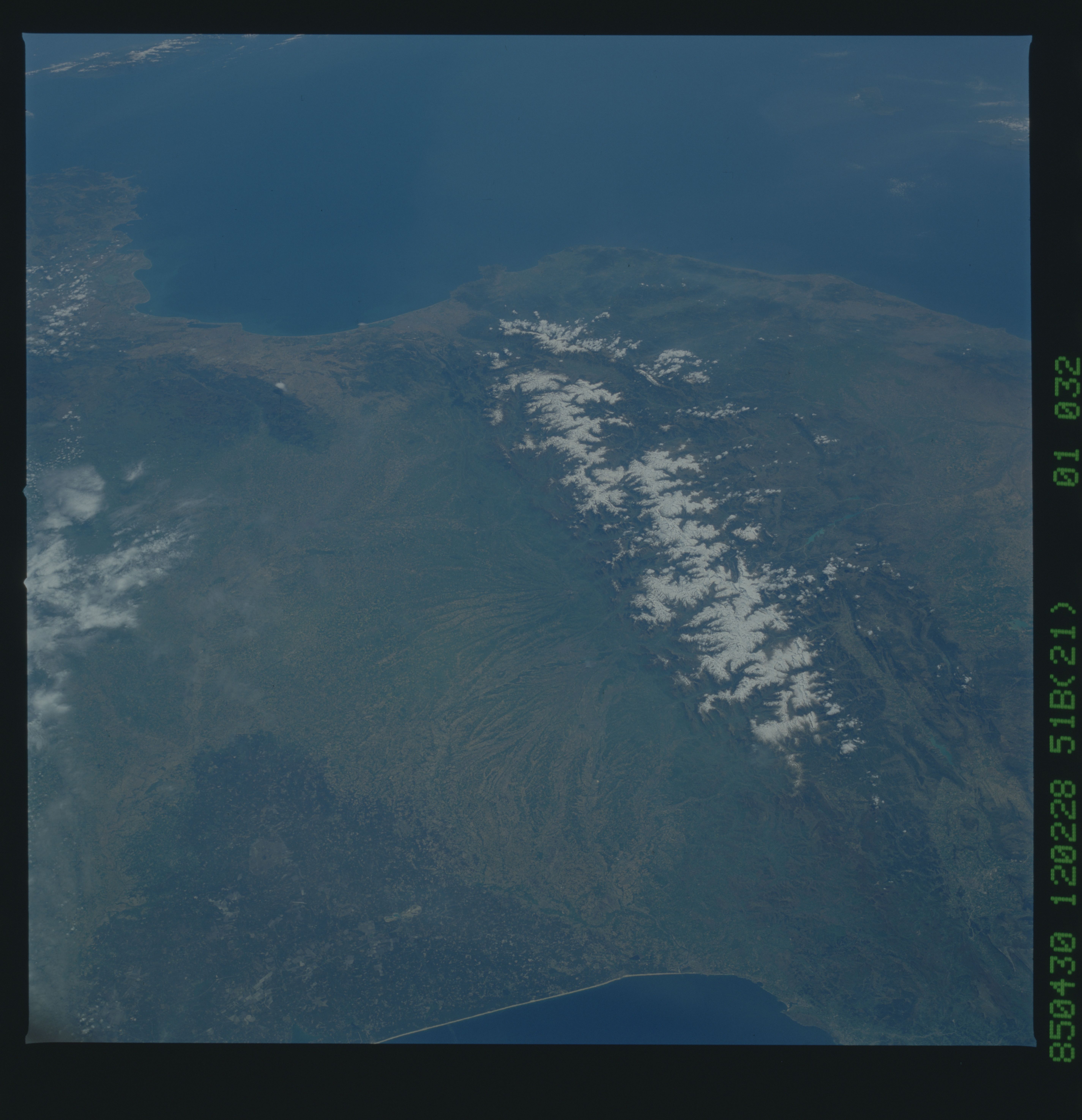
Image Caption: STS51B-31-81 Pyrenees Mountains, France and Spain April 1985
The snow-covered Pyrenees Mountains, which form a formidable physical barrier between France to the north and Spain to the south, are the main focus of this low-oblique, southeast-looking photograph. Scarcely interrupted by accessible passes and pierced in only two places by railroad tunnels, the Pyrenees are an ideal natural boundary between the Iberian Peninsula and the rest of Europe. The northern flank of the Pyrenees is characterized by a series of large alluvial deposits that fan out across southwestern France. The darker, roughly triangular area in southwest France is part of the forested Aquitaine Basin. This region is near the major port city of Bordeaux (not visible in this photograph), which is known for its world-famous wine production. The southern flank of the Pyrenees (Spain) is characterized by aridity and very rugged, mountainous conditions. Human settlement is sparse throughout the Pyrenees; however, because the region is rich in mineral waters, there are dozens of mineral water resorts, and winter sports attract visitors from southwestern France. The very small mountainous country of Andorra (not distinguishable in this photograph) has survived in an inaccessible upper valley of the Pyrenees.
The snow-covered Pyrenees Mountains, which form a formidable physical barrier between France to the north and Spain to the south, are the main focus of this low-oblique, southeast-looking photograph. Scarcely interrupted by accessible passes and pierced in only two places by railroad tunnels, the Pyrenees are an ideal natural boundary between the Iberian Peninsula and the rest of Europe. The northern flank of the Pyrenees is characterized by a series of large alluvial deposits that fan out across southwestern France. The darker, roughly triangular area in southwest France is part of the forested Aquitaine Basin. This region is near the major port city of Bordeaux (not visible in this photograph), which is known for its world-famous wine production. The southern flank of the Pyrenees (Spain) is characterized by aridity and very rugged, mountainous conditions. Human settlement is sparse throughout the Pyrenees; however, because the region is rich in mineral waters, there are dozens of mineral water resorts, and winter sports attract visitors from southwestern France. The very small mountainous country of Andorra (not distinguishable in this photograph) has survived in an inaccessible upper valley of the Pyrenees.
