STS41G-120-82
| NASA Photo ID | STS41G-120-82 |
| Focal Length | 90mm |
| Date taken | 1984.10.__ |
| Time taken | GMT |
Resolutions offered for this image:
640 x 480 pixels
640 x 480 pixels
Cloud masks available for this image:
Spacecraft nadir point:
Photo center point: 37.5° N, 0.0° E
Photo center point by machine learning:
Photo center point: 37.5° N, 0.0° E
Photo center point by machine learning:
Nadir to Photo Center:
Spacecraft Altitude: nautical miles (0km)
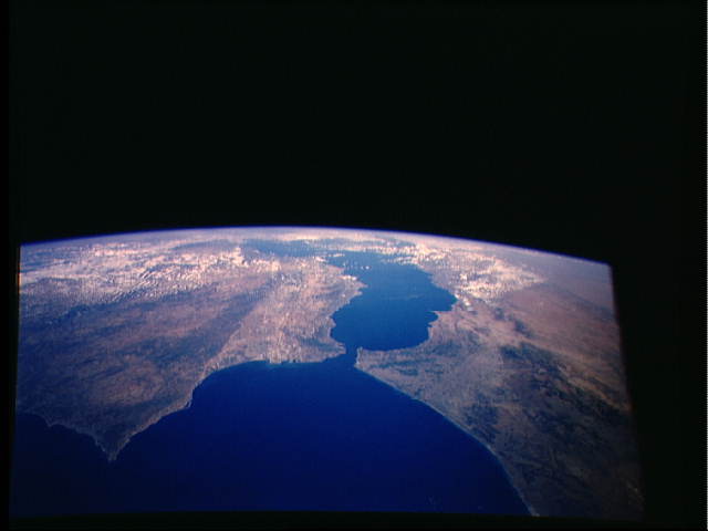
Country or Geographic Name: | SPAIN |
Features: | STRAIT OF GIBRALTAR |
| Features Found Using Machine Learning: | |
Cloud Cover Percentage: | 20 (11-25)% |
Sun Elevation Angle: | ° |
Sun Azimuth: | ° |
Camera: | Linhof |
Focal Length: | 90mm |
Camera Tilt: | High Oblique |
Format: | 6017: Kodak Ektachrome 64, 220 Roll Format |
Film Exposure: | Normal |
| Additional Information | |
| Width | Height | Annotated | Cropped | Purpose | Links |
|---|---|---|---|---|---|
| 640 pixels | 480 pixels | No | No | ISD 1 | Download Image |
Download Packaged File
Download a Google Earth KML for this Image
View photo footprint information
Download a GeoTIFF for this photo
Image Caption: The Strait of Gibraltar (36.0N, 5.5W) as seen from the mid Atlantic looking due east into the world of the Mediterranean. In this one panoramic scene, it is apparent how the Strait, known since ancient times as the gates of Hercules, has been a boundry between the old and the new world as well as between Europe to the north and Africa to the south.
