STS41D-41-33

| NASA Photo ID | STS41D-41-33 |
| Focal Length | 250mm |
| Date taken | 1984.09.05 |
| Time taken | 04:56:11 GMT |
Resolutions offered for this image:
3921 x 3840 pixels 640 x 626 pixels 4440 x 4600 pixels 483 x 500 pixels 640 x 480 pixels
3921 x 3840 pixels 640 x 626 pixels 4440 x 4600 pixels 483 x 500 pixels 640 x 480 pixels


Cloud masks available for this image:
Spacecraft nadir point: 23.8° S, 134.6° E
Photo center point: 23.5° S, 134.5° E
Photo center point by machine learning:
Photo center point: 23.5° S, 134.5° E
Photo center point by machine learning:
Nadir to Photo Center: North
Spacecraft Altitude: 161 nautical miles (298km)
Country or Geographic Name: | AUSTRALIA-NT |
Features: | MACDONNELL RANGES |
| Features Found Using Machine Learning: | |
Cloud Cover Percentage: | 0 (no clouds present) |
Sun Elevation Angle: | 48° |
Sun Azimuth: | 106° |
Camera: | Hasselblad |
Focal Length: | 250mm |
Camera Tilt: | 7 degrees |
Format: | 6017: Kodak Ektachrome 64, 220 Roll Format |
Film Exposure: | Normal |
| Additional Information | |
| Width | Height | Annotated | Cropped | Purpose | Links |
|---|---|---|---|---|---|
| 3921 pixels | 3840 pixels | No | No | Earth From Space collection | Download Image |
| 640 pixels | 626 pixels | No | No | Earth From Space collection | Download Image |
| 4440 pixels | 4600 pixels | No | No | Download Image | |
| 483 pixels | 500 pixels | No | No | Download Image | |
| 640 pixels | 480 pixels | No | No | Download Image |
Download Packaged File
Download a Google Earth KML for this Image
View photo footprint information
Download a GeoTIFF for this photo
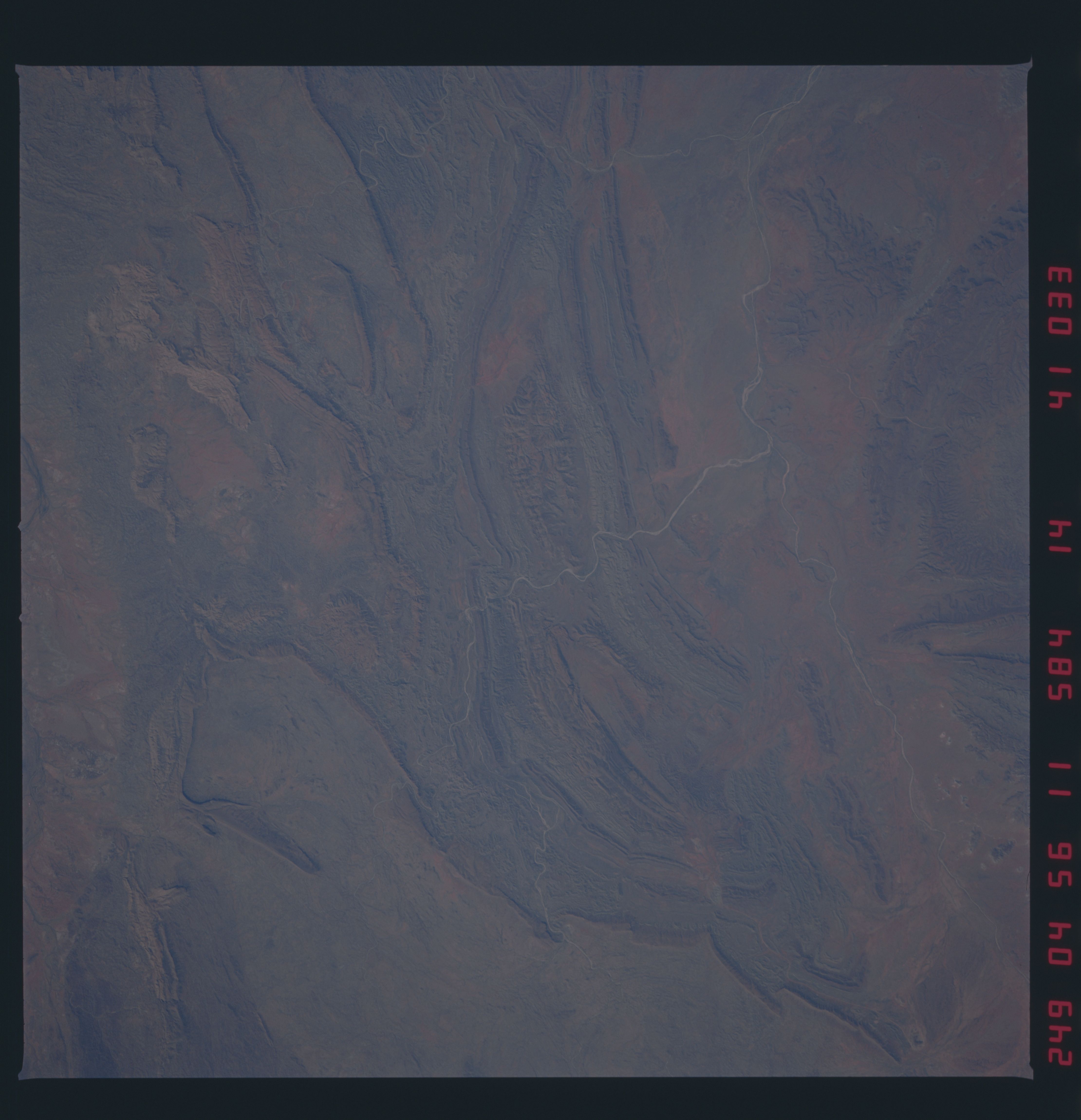
Image Caption: STS41D-41-0033 MacDonnell Ranges, Northern Territory, Australia September 1984
The Todd River transects the northeastern part of the folded MacDonnell Ranges in the area east of Alice Springs. The main channel is barely visible as it cuts through a valley near the bottom of the picture. Two generally south-flowing tributaries of the Todd River can also be seen; the westernmost tributary is the more reflective stream bed near the center of the image. All of these desert streams are ephemeral. Mount Laughlen at 3827 feet (1166 meters) above sea level is north of the westernmost tributary, slightly above the center of the image.
The Todd River transects the northeastern part of the folded MacDonnell Ranges in the area east of Alice Springs. The main channel is barely visible as it cuts through a valley near the bottom of the picture. Two generally south-flowing tributaries of the Todd River can also be seen; the westernmost tributary is the more reflective stream bed near the center of the image. All of these desert streams are ephemeral. Mount Laughlen at 3827 feet (1166 meters) above sea level is north of the westernmost tributary, slightly above the center of the image.
