STS118-E-9469
| NASA Photo ID | STS118-E-9469 |
| Focal Length | 28mm |
| Date taken | 2007.08.19 |
| Time taken | 12:40:23 GMT |
Resolutions offered for this image:
1000 x 667 pixels 540 x 360 pixels 540 x 405 pixels 3032 x 2064 pixels 639 x 435 pixels
1000 x 667 pixels 540 x 360 pixels 540 x 405 pixels 3032 x 2064 pixels 639 x 435 pixels

Cloud masks available for this image:
Spacecraft nadir point: 36.9° N, 15.6° E
Photo center point: 39.5° N, 19.8° E
Photo center point by machine learning:
Photo center point: 39.5° N, 19.8° E
Photo center point by machine learning:
Nadir to Photo Center: Northeast
Spacecraft Altitude: 185 nautical miles (343km)
Country or Geographic Name: | GREECE |
Features: | STRAIT OF OTRANTO, ISS |
| Features Found Using Machine Learning: | PAN- |
Cloud Cover Percentage: | 10 (1-10)% |
Sun Elevation Angle: | 57° |
Sun Azimuth: | 229° |
Camera: | Kodak DCS760c Electronic Still Camera |
Focal Length: | 28mm |
Camera Tilt: | High Oblique |
Format: | 3060E: 3060 x 2036 pixel CCD, RGBG array |
Film Exposure: | |
| Additional Information | |
| Width | Height | Annotated | Cropped | Purpose | Links |
|---|---|---|---|---|---|
| 1000 pixels | 667 pixels | No | Yes | Earth From Space collection | Download Image |
| 540 pixels | 360 pixels | Yes | Yes | Earth From Space collection | Download Image |
| 540 pixels | 405 pixels | Yes | Yes | NASA's Earth Observatory web site | Download Image |
| 3032 pixels | 2064 pixels | No | No | Download Image | |
| 639 pixels | 435 pixels | No | No | Download Image |
Download Packaged File
Download a Google Earth KML for this Image
View photo footprint information
Download a GeoTIFF for this photo
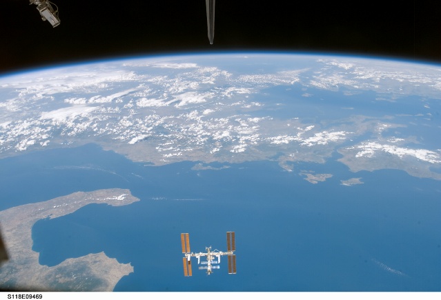
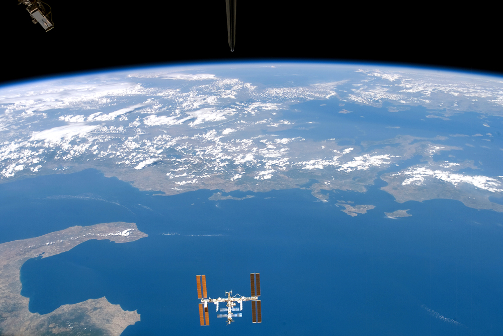
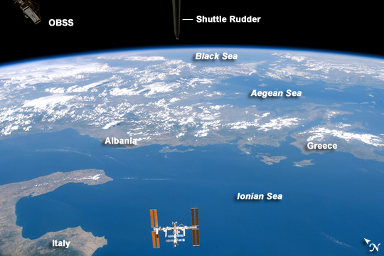
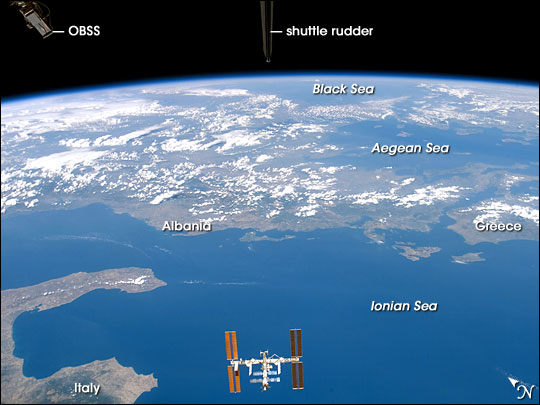
Image Caption: International Space Station from Space Shuttle Endeavour
The crew of the Space Shuttle Endeavour took this spectacular image of the International Space Station during the STS118 mission, August 8-21, 2007. The image was acquired by an astronaut through one of the crew cabin windows, looking back over the length of the Shuttle. Endeavour had undocked from the International Space Station, and the crew had begun late inspection of the orbiter's Thermal Protection System (wing leading edges, nosecap, and belly tiles) prior to landing. The late inspection is performed using sensors mounted on the Orbiter Boom Sensor System, and the goal is to assess whether micrometeorite or orbiting debris have compromised the Thermal Protection System of the Shuttle while it was docked with the International Space Station.
This oblique (looking at an angle from vertical, rather than straight down towards the Earth) image was acquired almost one hour after late inspection activities had begun. The sensor head of the Orbiter Boom Sensor System is visible at image top left. The entire Space Station is visible at image bottom center, set against the backdrop of the Ionian Sea approximately 330 kilometers below it. Other visible features of the southeastern Mediterranean region include the toe and heel of Italy's "boot" at image lower left, and the western coastlines of Albania and Greece, which extend across image center. Farther towards the horizon, the Aegean and Black Seas are also visible.
