STS108-722-60

| NASA Photo ID | STS108-722-60 |
| Focal Length | 110mm |
| Date taken | 2001.12.16 |
| Time taken | 12:10:02 GMT |
Resolutions offered for this image:
540 x 530 pixels 1031 x 1024 pixels 2063 x 2048 pixels 4127 x 4096 pixels 515 x 512 pixels 1240 x 1216 pixels 1240 x 1216 pixels 400 x 393 pixels
540 x 530 pixels 1031 x 1024 pixels 2063 x 2048 pixels 4127 x 4096 pixels 515 x 512 pixels 1240 x 1216 pixels 1240 x 1216 pixels 400 x 393 pixels


Cloud masks available for this image:
Spacecraft nadir point: 48.9° S, 80.9° W
Photo center point: 47.0° S, 73.5° W
Photo center point by machine learning:
Photo center point: 47.0° S, 73.5° W
Photo center point by machine learning:
Nadir to Photo Center: East
Spacecraft Altitude: 204 nautical miles (378km)
Camera: | Hasselblad |
Focal Length: | 110mm |
Camera Tilt: | High Oblique |
Format: | 5069: Kodak Elite 100S, E6 Reversal, Replaces Lumiere, Warmer in tone vs. Lumiere |
Film Exposure: | |
| Additional Information | |
| Width | Height | Annotated | Cropped | Purpose | Links |
|---|---|---|---|---|---|
| 540 pixels | 530 pixels | Yes | Yes | Earth From Space collection | Download Image |
| 1031 pixels | 1024 pixels | No | No | Download Image | |
| 2063 pixels | 2048 pixels | No | No | Download Image | |
| 4127 pixels | 4096 pixels | No | No | Download Image | |
| 515 pixels | 512 pixels | No | No | Download Image | |
| 1240 pixels | 1216 pixels | No | Photographic Highlights | Download Image | |
| 1240 pixels | 1216 pixels | No | No | Download Image | |
| 400 pixels | 393 pixels | Yes | Photographic Highlights | Download Image |
Download Packaged File
Download a Google Earth KML for this Image
View photo footprint information
Download a GeoTIFF for this photo
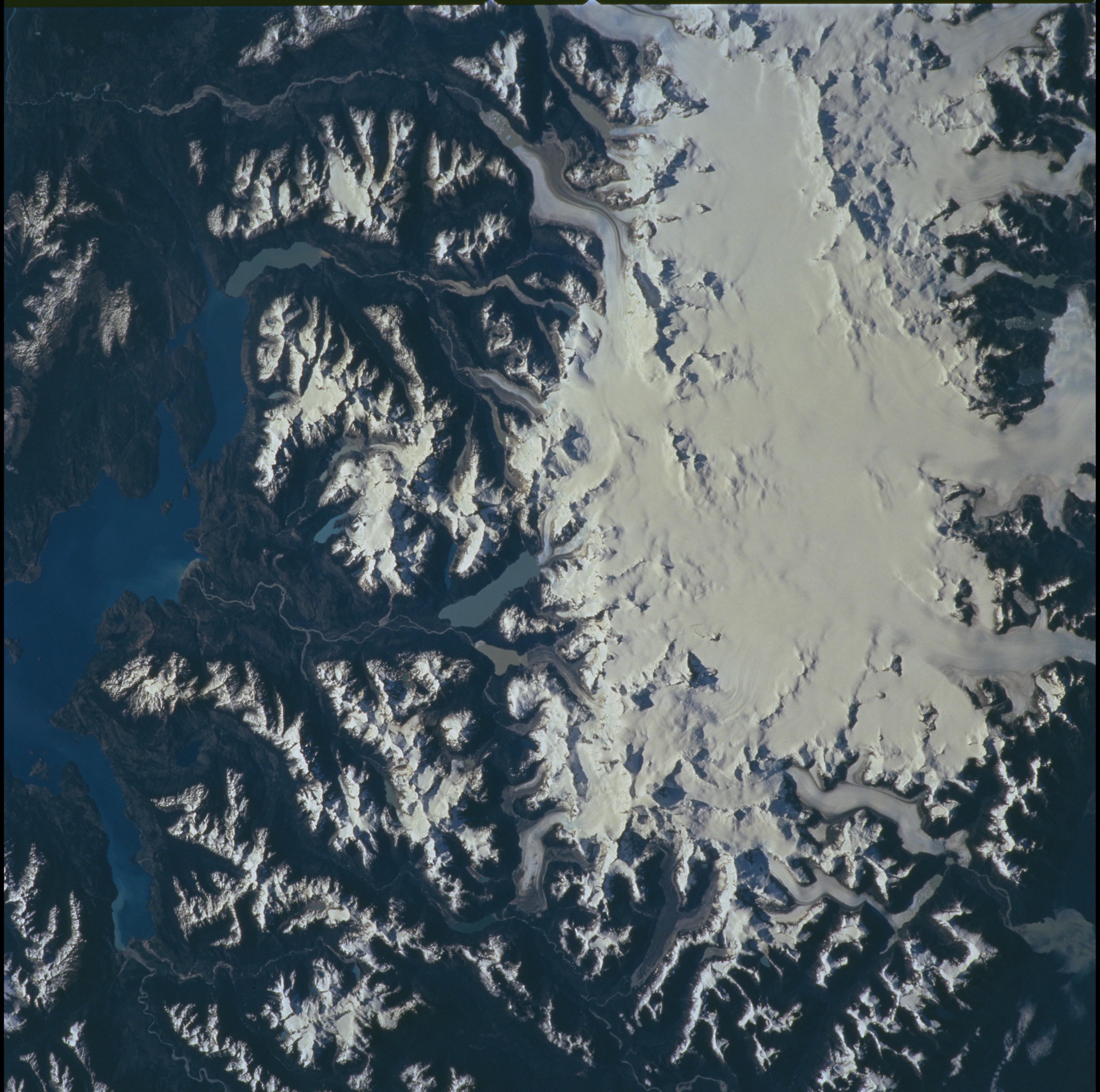
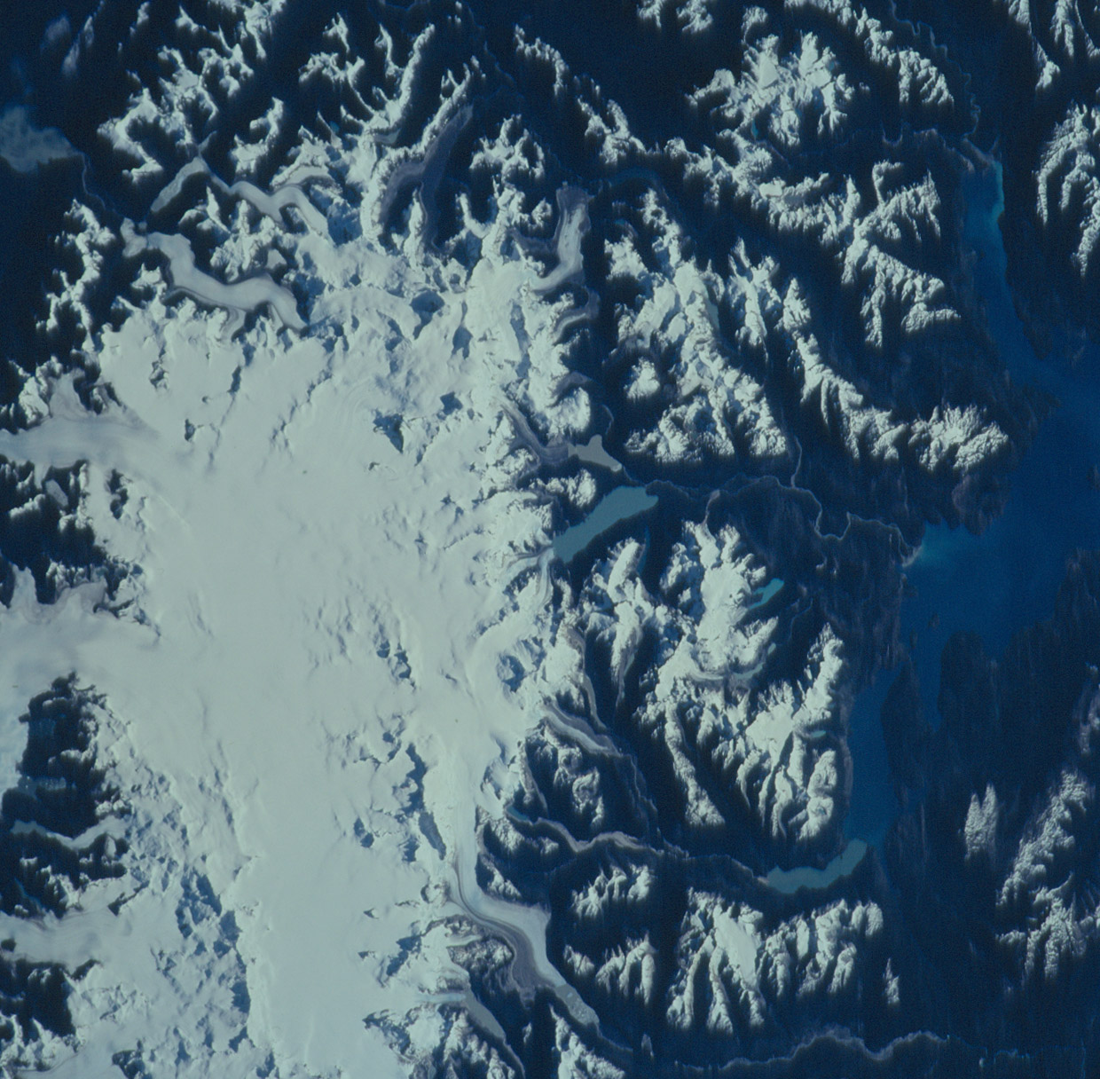
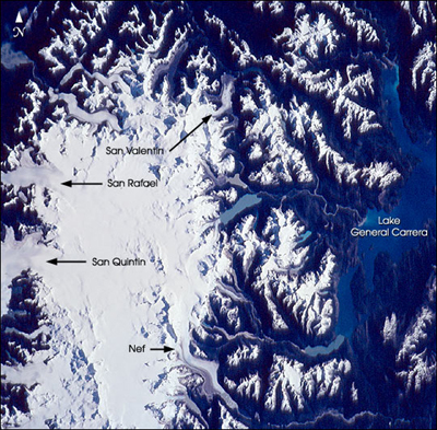
Image Caption: The Northern Patagonian Ice Field (NPIF), centered near 47degS, 73.5degW, is the smaller of two remnant ice masses crowning the Andes Mountains of lower South America. The NPIF is a vestige of an extensive ice sheet that covered much of Patagonia just over a million years ago. Today, with its glaciers largely in retreat and only an area of 4,200 sq km, it is still the largest continuous mass of ice outside of the polar regions. Survival is based on its elevation (1, 100 to 1,500 m), favorable terrain, and a cool, moist, marine climate. The ice field has 28 exit glaciers, the largest two--San Quintin and San Rafael--nearly reach sea level to the west at the Pacific Ocean. Smaller exit glaciers, like San Valentin and Nef, feed numerous rivers and glacially carved lakes to the east.
This photo taken by the crew of STS-108 in December, 2001, offers a remarkably clear view of the northern two-thirds of this bright, icy feature, its glaciers, and its northern and eastern flanks. Arms of Lake General Carrera are visible on the right of the image. Such photos offer unsurpassed visual context information about the state of this remote locale and details of its features and processes.
This photo taken by the crew of STS-108 in December, 2001, offers a remarkably clear view of the northern two-thirds of this bright, icy feature, its glaciers, and its northern and eastern flanks. Arms of Lake General Carrera are visible on the right of the image. Such photos offer unsurpassed visual context information about the state of this remote locale and details of its features and processes.
