STS108-721-81

| NASA Photo ID | STS108-721-81 |
| Focal Length | 110mm |
| Date taken | 2001.12.12 |
| Time taken | 14:49:26 GMT |
Resolutions offered for this image:
1031 x 1024 pixels 2063 x 2048 pixels 4127 x 4096 pixels 515 x 512 pixels 4095 x 4095 pixels 640 x 640 pixels 400 x 400 pixels
1031 x 1024 pixels 2063 x 2048 pixels 4127 x 4096 pixels 515 x 512 pixels 4095 x 4095 pixels 640 x 640 pixels 400 x 400 pixels


Cloud masks available for this image:
Spacecraft nadir point: 19.0° N, 17.1° W
Photo center point: 18.5° N, 16.0° W
Photo center point by machine learning:
Photo center point: 18.5° N, 16.0° W
Photo center point by machine learning:
Nadir to Photo Center: East
Spacecraft Altitude: 204 nautical miles (378km)
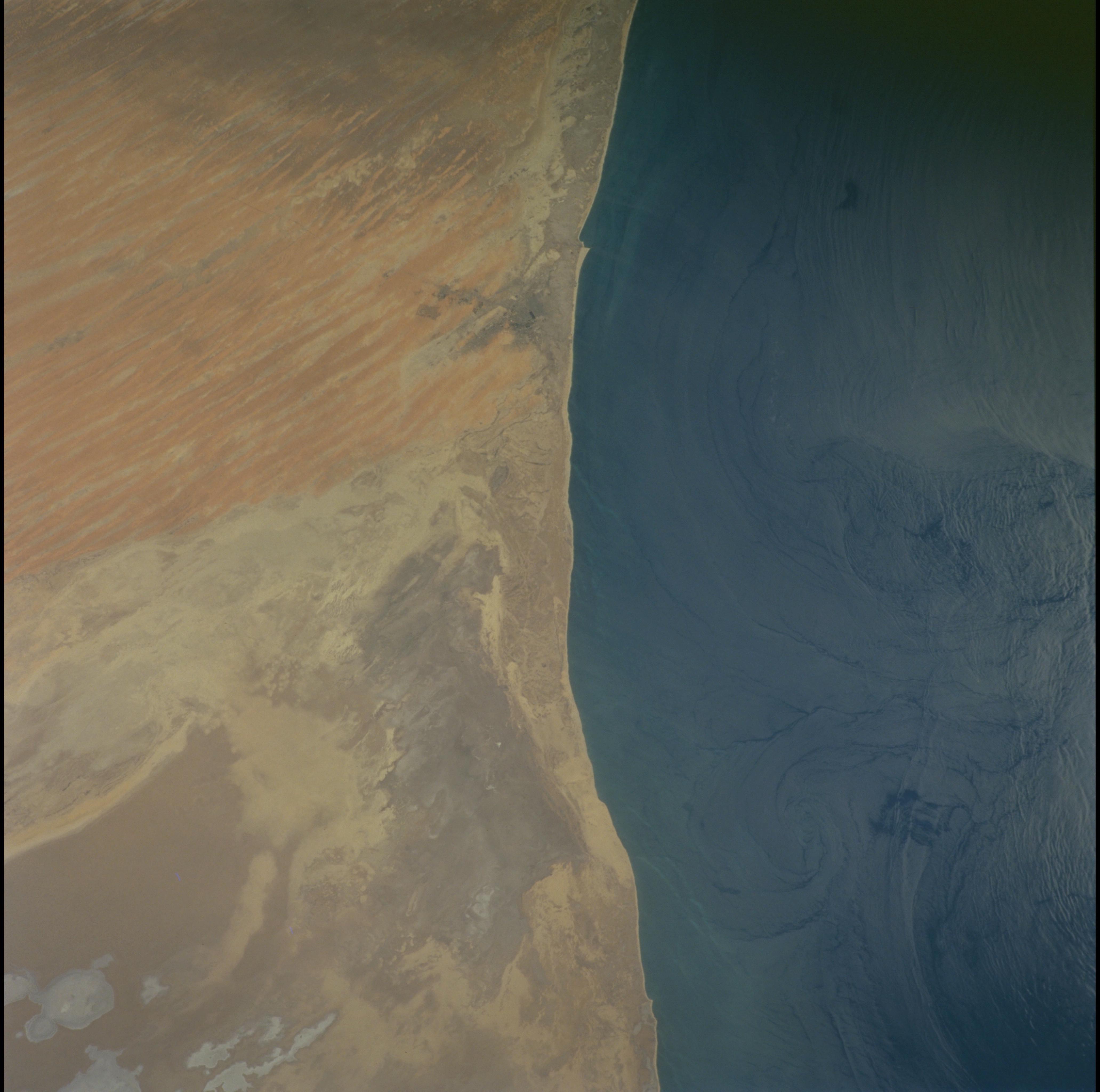
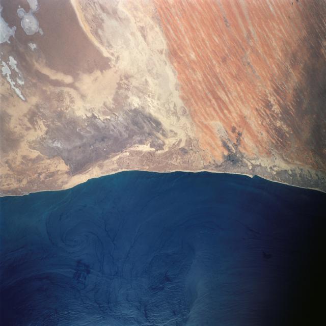
Country or Geographic Name: | MAURITANIA |
Features: | SALT FLATS, WIND STREAKS |
| Features Found Using Machine Learning: | |
Cloud Cover Percentage: | 10 (1-10)% |
Sun Elevation Angle: | 41° |
Sun Azimuth: | 213° |
Camera: | Hasselblad |
Focal Length: | 110mm |
Camera Tilt: | 20 degrees |
Format: | 5069: Kodak Elite 100S, E6 Reversal, Replaces Lumiere, Warmer in tone vs. Lumiere |
Film Exposure: | |
| Additional Information | |
| Width | Height | Annotated | Cropped | Purpose | Links |
|---|---|---|---|---|---|
| 1031 pixels | 1024 pixels | No | No | Download Image | |
| 2063 pixels | 2048 pixels | No | No | Download Image | |
| 4127 pixels | 4096 pixels | No | No | Download Image | |
| 515 pixels | 512 pixels | No | No | Download Image | |
| 4095 pixels | 4095 pixels | No | No | Public Affairs Office (PAO) | Download Image |
| 640 pixels | 640 pixels | No | No | Public Affairs Office (PAO) | Download Image |
| 400 pixels | 400 pixels | No | No | Photographic Highlights | Download Image |
Download Packaged File
Download a Google Earth KML for this Image
View photo footprint information
Download a GeoTIFF for this photo
Image Caption: Atlantic coast. Red lines are sand dunes aligned parallel to the dominant
offshore, northeasterly winds. Large ray-brwon areas left are vast coastal
salt flats known as sebkhas. Visible salt efflorescences are the small
lightest gray patches. Offshore currents in sunglint with internal waves (
straighter lines) and eddies (spirals). North is to the left.
offshore, northeasterly winds. Large ray-brwon areas left are vast coastal
salt flats known as sebkhas. Visible salt efflorescences are the small
lightest gray patches. Offshore currents in sunglint with internal waves (
straighter lines) and eddies (spirals). North is to the left.
