STS108-705-8
| NASA Photo ID | STS108-705-8 |
| Focal Length | 110mm |
| Date taken | 2001.12.__ |
| Time taken | GMT |
Resolutions offered for this image:
1031 x 1024 pixels 2063 x 2048 pixels 4127 x 4096 pixels 515 x 512 pixels 4095 x 4095 pixels 640 x 640 pixels 400 x 398 pixels
1031 x 1024 pixels 2063 x 2048 pixels 4127 x 4096 pixels 515 x 512 pixels 4095 x 4095 pixels 640 x 640 pixels 400 x 398 pixels


Cloud masks available for this image:
Spacecraft nadir point:
Photo center point: 21.0° N, 11.5° W
Photo center point by machine learning:
Photo center point: 21.0° N, 11.5° W
Photo center point by machine learning:
Nadir to Photo Center:
Spacecraft Altitude: nautical miles (0km)
Country or Geographic Name: | MAURITANIA |
Features: | RICHAT STRUCTURE |
| Features Found Using Machine Learning: | |
Cloud Cover Percentage: | 10 (1-10)% |
Sun Elevation Angle: | ° |
Sun Azimuth: | ° |
Camera: | Hasselblad |
Focal Length: | 110mm |
Camera Tilt: | |
Format: | 5069: Kodak Elite 100S, E6 Reversal, Replaces Lumiere, Warmer in tone vs. Lumiere |
Film Exposure: | |
| Additional Information | |
| Width | Height | Annotated | Cropped | Purpose | Links |
|---|---|---|---|---|---|
| 1031 pixels | 1024 pixels | No | No | Download Image | |
| 2063 pixels | 2048 pixels | No | No | Download Image | |
| 4127 pixels | 4096 pixels | No | No | Download Image | |
| 515 pixels | 512 pixels | No | No | Download Image | |
| 4095 pixels | 4095 pixels | Public Affairs Office (PAO) | Download Image | ||
| 640 pixels | 640 pixels | No | No | Public Affairs Office (PAO) | Download Image |
| 400 pixels | 398 pixels | No | No | Photographic Highlights | Download Image |
Download Packaged File
Download a Google Earth KML for this Image
View photo footprint information
Download a GeoTIFF for this photo
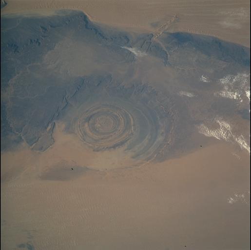
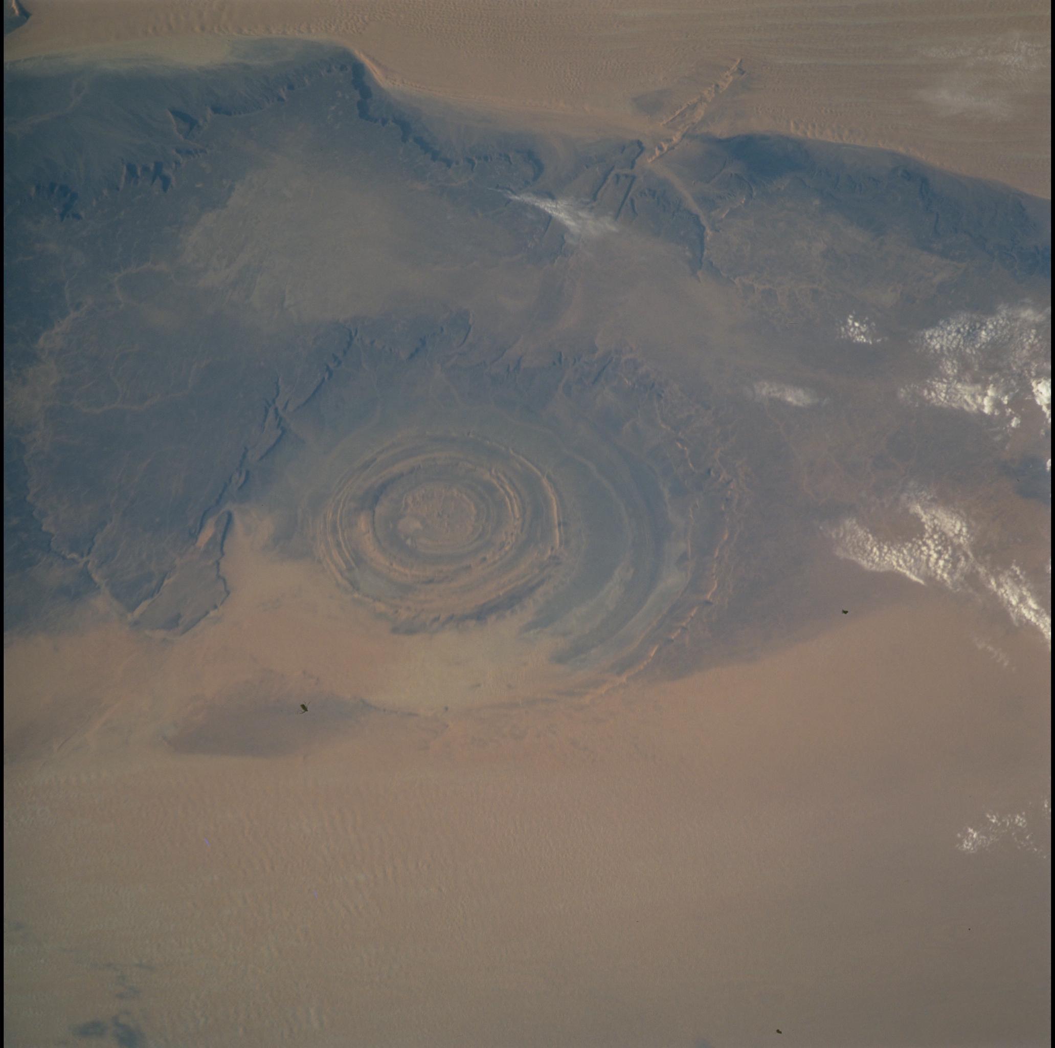
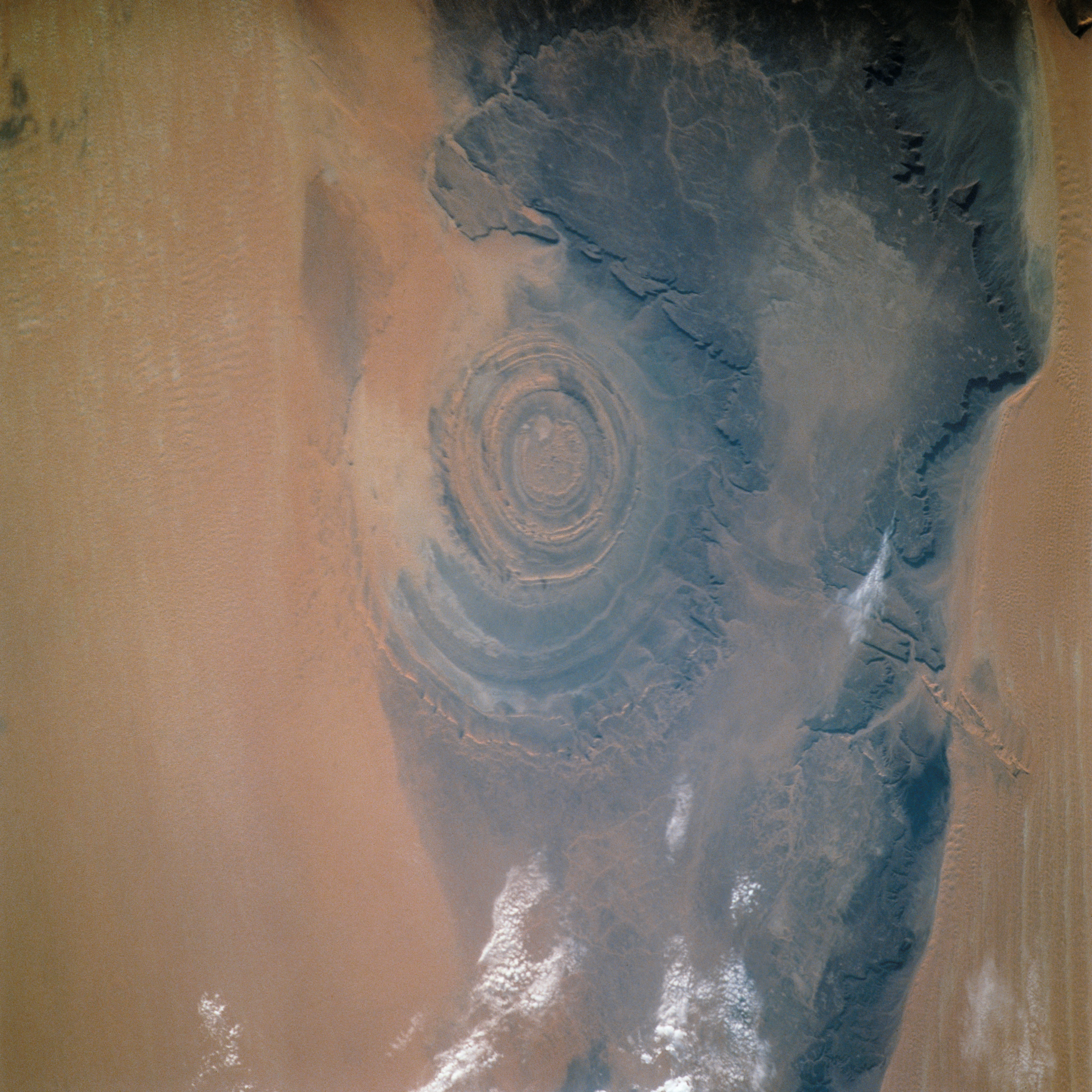
Image Caption: Richat Structure
The "bulls eye" of the Richat Structure, stands out in the midst of the barren Gres de Chinguetti Plateau in central Mauritania, northwest Africa. The structure represents uplifted, layered (sedimentary) rocks that have been eroded by water and wind into the present shape. Desert sands have invaded the feature from the south.
The "bulls eye" of the Richat Structure, stands out in the midst of the barren Gres de Chinguetti Plateau in central Mauritania, northwest Africa. The structure represents uplifted, layered (sedimentary) rocks that have been eroded by water and wind into the present shape. Desert sands have invaded the feature from the south.
