STS106-718-56
| NASA Photo ID | STS106-718-56 |
| Focal Length | 250mm |
| Date taken | 2000.09.11 |
| Time taken | 09:35:24 GMT |
Resolutions offered for this image:
1031 x 1024 pixels 2063 x 2048 pixels 4127 x 4096 pixels 639 x 636 pixels 515 x 512 pixels
1031 x 1024 pixels 2063 x 2048 pixels 4127 x 4096 pixels 639 x 636 pixels 515 x 512 pixels


Cloud masks available for this image:
Spacecraft nadir point: 37.1° N, 68.5° E
Photo center point: 36.0° N, 62.0° E
Photo center point by machine learning:
Photo center point: 36.0° N, 62.0° E
Photo center point by machine learning:
Nadir to Photo Center: West
Spacecraft Altitude: 191 nautical miles (354km)
Country or Geographic Name: | TURKMENISTAN |
Features: | MURGAB RIVER, DUST PALL |
| Features Found Using Machine Learning: | |
Cloud Cover Percentage: | 10 (1-10)% |
Sun Elevation Angle: | 45° |
Sun Azimuth: | 231° |
Camera: | Hasselblad |
Focal Length: | 250mm |
Camera Tilt: | High Oblique |
Format: | 5069: Kodak Elite 100S, E6 Reversal, Replaces Lumiere, Warmer in tone vs. Lumiere |
Film Exposure: | |
| Additional Information | |
| Width | Height | Annotated | Cropped | Purpose | Links |
|---|---|---|---|---|---|
| 1031 pixels | 1024 pixels | No | No | Download Image | |
| 2063 pixels | 2048 pixels | No | No | Download Image | |
| 4127 pixels | 4096 pixels | No | No | Download Image | |
| 639 pixels | 636 pixels | No | No | Download Image | |
| 515 pixels | 512 pixels | No | No | Download Image |
Download Packaged File
Download a Google Earth KML for this Image
View photo footprint information
Download a GeoTIFF for this photo
Image Caption: Source: Justin Wilkinson
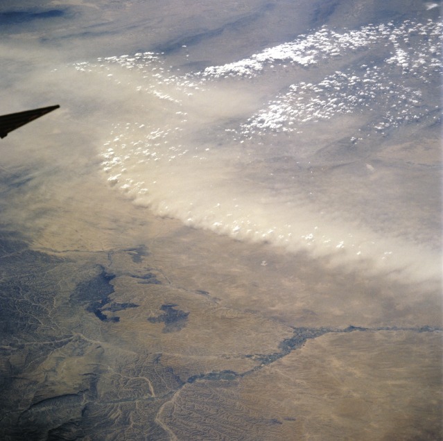
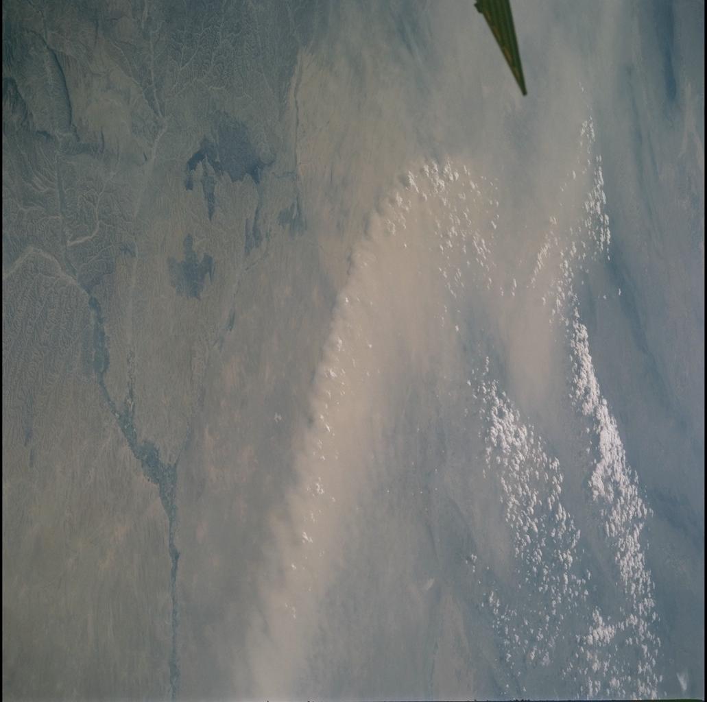
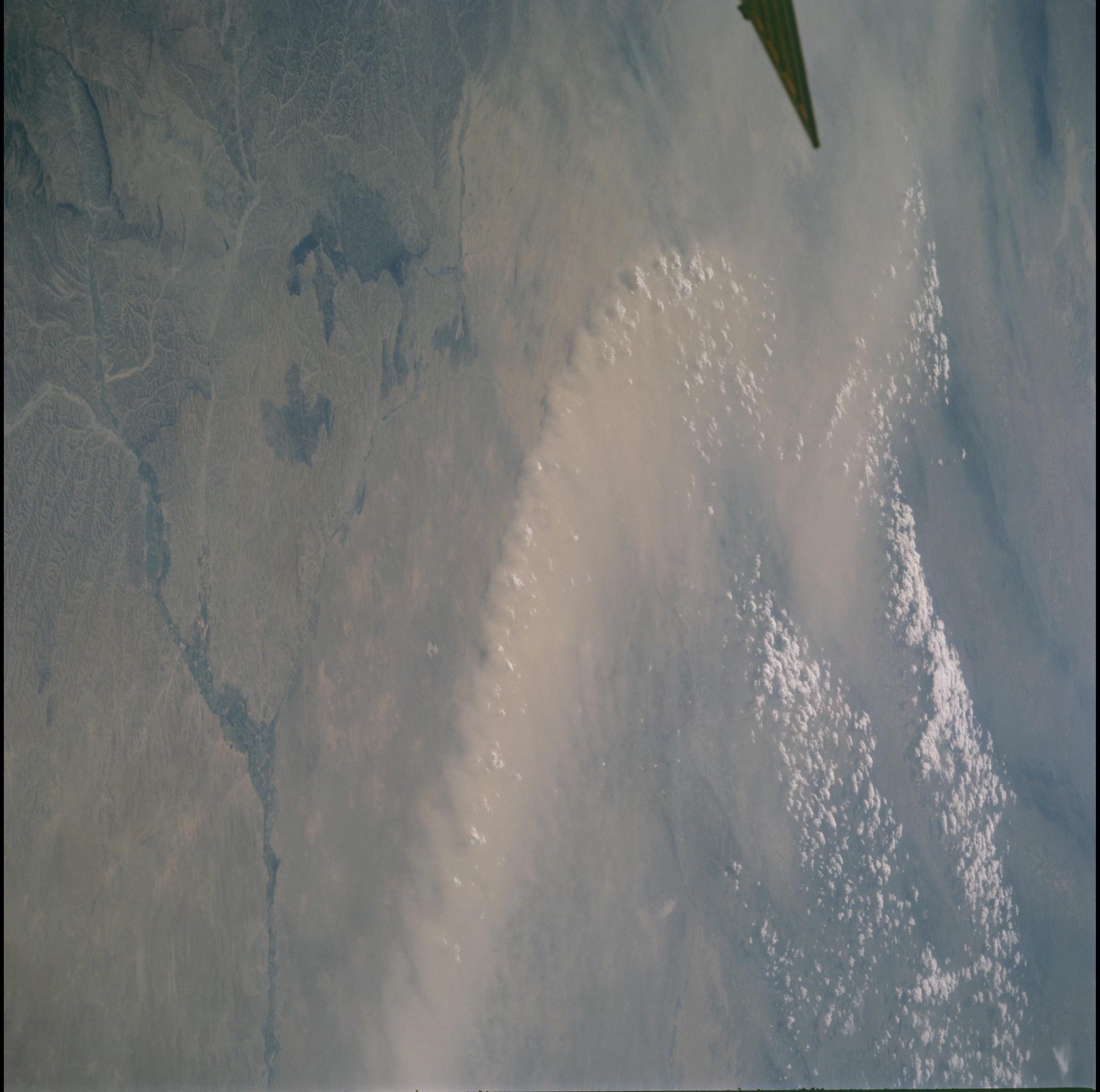
Afghanistan Dust Front
Winds in the upper Amu Darya valley, along the northern border of
Afghanistan lofted thick, light brown dust into the air (top half of the
view). In this desert environment land surfaces are not protected by
vegetation from the effect of blowing wind. The central Asian deserts
experience the greatest number of dust storm days on the planet each
year. The sharp dust front shows that the dust has not traveled far, but
has been raised from the surfaces in the view.
Dust is entrained in the atmosphere by horizontal winds but also by
vertical movements. Here the vertical component is indicated by the fact
that the higher points along the dust front are each topped by a small
cumulus cloud, which appear as a line of small white puffballs. Cumulus
clouds indicate upward motion and here the air which has entrained the
dust is lifting the air above to the level of condensation at each point
where a small cloud has formed.
