STS105-E-5416
| NASA Photo ID | STS105-E-5416 |
| Focal Length | 180mm |
| Date taken | 2001.08.20 |
| Time taken | 21:37:30 GMT |
Resolutions offered for this image:
540 x 351 pixels 3040 x 2064 pixels 640 x 434 pixels 400 x 257 pixels
540 x 351 pixels 3040 x 2064 pixels 640 x 434 pixels 400 x 257 pixels

Cloud masks available for this image:
Spacecraft nadir point: 43.7° N, 122.3° W
Photo center point: 39.5° N, 122.5° W
Photo center point by machine learning:
Photo center point: 39.5° N, 122.5° W
Photo center point by machine learning:
Nadir to Photo Center: South
Spacecraft Altitude: 200 nautical miles (370km)
Country or Geographic Name: | USA-CALIFORNIA |
Features: | COAST RANGE, FOREST FIRE |
| Features Found Using Machine Learning: | |
Cloud Cover Percentage: | 10 (1-10)% |
Sun Elevation Angle: | 54° |
Sun Azimuth: | 217° |
Camera: | Kodak DCS660 Electronic Still Camera |
Focal Length: | 180mm |
Camera Tilt: | 52 degrees |
Format: | 3060E: 3060 x 2036 pixel CCD, RGBG array |
Film Exposure: | |
| Additional Information | |
| Width | Height | Annotated | Cropped | Purpose | Links |
|---|---|---|---|---|---|
| 540 pixels | 351 pixels | Yes | Yes | NASA's Earth Observatory web site | Download Image |
| 3040 pixels | 2064 pixels | No | No | Download Image | |
| 640 pixels | 434 pixels | No | No | Download Image | |
| 400 pixels | 257 pixels | Yes | Yes | Photographic Highlights | Download Image |
Download Packaged File
Download a Google Earth KML for this Image
View photo footprint information
Download a GeoTIFF for this photo
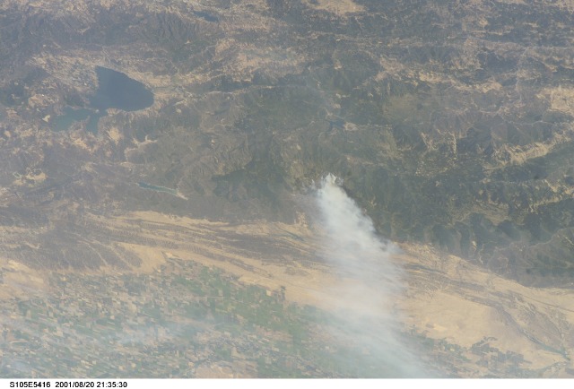
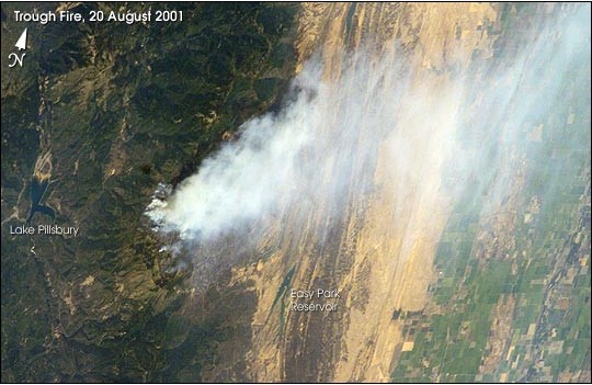
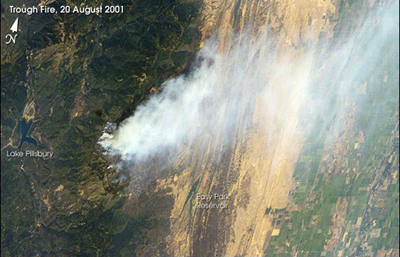
Image Caption: After undocking with Space Station Alpha, on August 20, 2001, astronauts on the Space Shuttle photographed wildfires burning in the western U.S. using a digital camera. Zooming in with a longer lens length, astronauts recorded details of individual fires. The digital images were then downlinked to the ground.
The Trough Fire, burning in Mendocino National Forest was 76 percent contained and had burned 16,751 acres at the time the photo was taken. Information on fire status and locations was obtained from the National Fire Interagency Center and U.S. Forest Service Detailed Fire Intelligence (//www.fire.r5.fs.fed.us/scsc/sitreport-archive/082001-sitreport.html).
The Trough Fire, burning in Mendocino National Forest was 76 percent contained and had burned 16,751 acres at the time the photo was taken. Information on fire status and locations was obtained from the National Fire Interagency Center and U.S. Forest Service Detailed Fire Intelligence (//www.fire.r5.fs.fed.us/scsc/sitreport-archive/082001-sitreport.html).
