STS105-E-5343
| NASA Photo ID | STS105-E-5343 |
| Focal Length | 400mm |
| Date taken | 2001.08.19 |
| Time taken | 17:42:32 GMT |

Cloud masks available for this image:
Spacecraft nadir point: 12.9° N, 95.0° W
Photo center point: 16.0° N, 94.0° W
Photo center point by machine learning: 16.28° N, 94.40° W
Photo center point: 16.0° N, 94.0° W
Photo center point by machine learning: 16.28° N, 94.40° W
Nadir to Photo Center: North
Spacecraft Altitude: 211 nautical miles (391km)

Country or Geographic Name: | MEXICO |
Features: | MAR MUERTO |
| Features Found Using Machine Learning: | |
Cloud Cover Percentage: | 10 (1-10)% |
Sun Elevation Angle: | 80° |
Sun Azimuth: | 90° |
Camera: | Kodak DCS660 Electronic Still Camera |
Focal Length: | 400mm |
Camera Tilt: | 43 degrees |
Format: | 3060E: 3060 x 2036 pixel CCD, RGBG array |
Film Exposure: | |
| Additional Information | |
| Width | Height | Annotated | Cropped | Purpose | Links |
|---|---|---|---|---|---|
| 3040 pixels | 2064 pixels | No | No | Download Image | |
| 640 pixels | 434 pixels | No | No | Download Image | |
| 400 pixels | 264 pixels | No | No | Photographic Highlights | Download Image |
Download Packaged File
Download a Google Earth KML for this Image
View photo footprint information
Download a GeoTIFF for this photo
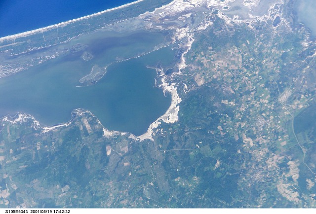
Image Caption: Laguna Mar Muerto, Mexico
The large body of water in the left center part of the image is the western end of the Laguna Mar Muerto. This saltwater lagoon is located along the Pacific Ocean coast in southern Mexico. Small cities with their distinctive grid street pattern are scattered throughout the multicolored, agricultural landscape. Highways that connect the farming communities along the narrow coastal plains are visible. The highly reflective area that fringes most of the lagoon is a transition zone where the changing tides have created a brackish marsh environment. A small section of the sandy beach that separates this large lagoon from the blue water of the Gulf of Tehuantepec is in the upper left corner of the image. North is towards the lower right corner of the image.
The large body of water in the left center part of the image is the western end of the Laguna Mar Muerto. This saltwater lagoon is located along the Pacific Ocean coast in southern Mexico. Small cities with their distinctive grid street pattern are scattered throughout the multicolored, agricultural landscape. Highways that connect the farming communities along the narrow coastal plains are visible. The highly reflective area that fringes most of the lagoon is a transition zone where the changing tides have created a brackish marsh environment. A small section of the sandy beach that separates this large lagoon from the blue water of the Gulf of Tehuantepec is in the upper left corner of the image. North is towards the lower right corner of the image.
