STS104-328-18

| NASA Photo ID | STS104-328-18 |
| Focal Length | mm |
| Date taken | 2001.07.24 |
| Time taken | 06:22:40 GMT |
Resolutions offered for this image:
2980 x 1963 pixels 3070 x 2044 pixels 515 x 339 pixels 640 x 421 pixels 400 x 263 pixels
2980 x 1963 pixels 3070 x 2044 pixels 515 x 339 pixels 640 x 421 pixels 400 x 263 pixels


Cloud masks available for this image:
Spacecraft nadir point: 32.3° N, 13.5° E
Photo center point: 38.0° N, 15.0° E
Photo center point by machine learning:
Photo center point: 38.0° N, 15.0° E
Photo center point by machine learning:
Nadir to Photo Center: North
Spacecraft Altitude: 210 nautical miles (389km)
Country or Geographic Name: | SICILY |
Features: | MT. ETNA ERUPTING |
| Features Found Using Machine Learning: | |
Cloud Cover Percentage: | 10 (1-10)% |
Sun Elevation Angle: | 25° |
Sun Azimuth: | 81° |
Camera: | |
Focal Length: | mm |
Camera Tilt: | High Oblique |
Format: | |
Film Exposure: | |
| Additional Information | |
| Width | Height | Annotated | Cropped | Purpose | Links |
|---|---|---|---|---|---|
| 2980 pixels | 1963 pixels | No | No | Download Image | |
| 3070 pixels | 2044 pixels | No | No | Download Image | |
| 515 pixels | 339 pixels | No | No | Download Image | |
| 640 pixels | 421 pixels | No | No | Public Affairs Office (PAO) | Download Image |
| 400 pixels | 263 pixels | No | No | Photographic Highlights | Download Image |
Download Packaged File
Download a Google Earth KML for this Image
View photo footprint information
Download a GeoTIFF for this photo
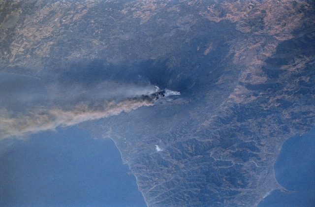
Image Caption: Mt. Etna, Sicily
This view of northeast Sicily shows two distinct atmospheric plumes being blown in a southeasterly direction during the summer 2001 eruption of Mt. Etna. The darker looking airborne plume is mainly an ash cloud that is being produced from an eruptive fissure along the southern flank of the volcano. The lighter colored plume is smoke that is coming from the cluster of vents located at the summit area of the volcano. The sizeable roughly circular base of the volcano is extensive, exceeding 60 kilometers (37 miles). The southwest view of the image shows the relationship of erupting Mt. Etna with the rolling fertile farmlands to the south and the mountains north of the volcano. The Peloritani Mountains of northeast Sicily present a rugged topographic landscape.
This view of northeast Sicily shows two distinct atmospheric plumes being blown in a southeasterly direction during the summer 2001 eruption of Mt. Etna. The darker looking airborne plume is mainly an ash cloud that is being produced from an eruptive fissure along the southern flank of the volcano. The lighter colored plume is smoke that is coming from the cluster of vents located at the summit area of the volcano. The sizeable roughly circular base of the volcano is extensive, exceeding 60 kilometers (37 miles). The southwest view of the image shows the relationship of erupting Mt. Etna with the rolling fertile farmlands to the south and the mountains north of the volcano. The Peloritani Mountains of northeast Sicily present a rugged topographic landscape.
