STS103-702-51
| NASA Photo ID | STS103-702-51 |
| Focal Length | 250mm |
| Date taken | 1999.12.23 |
| Time taken | 19:51:41 GMT |
Resolutions offered for this image:
1028 x 1024 pixels 2050 x 2048 pixels 4100 x 4096 pixels 514 x 512 pixels 638 x 639 pixels 4057 x 4065 pixels
1028 x 1024 pixels 2050 x 2048 pixels 4100 x 4096 pixels 514 x 512 pixels 638 x 639 pixels 4057 x 4065 pixels


Cloud masks available for this image:
Spacecraft nadir point: 16.9° N, 74.1° W
Photo center point: 25.0° N, 76.5° W
Photo center point by machine learning:
Photo center point: 25.0° N, 76.5° W
Photo center point by machine learning:
Nadir to Photo Center: North
Spacecraft Altitude: 317 nautical miles (587km)
Country or Geographic Name: | BAHAMAS |
Features: | ELEUTHERA ISLAND, REEFS |
| Features Found Using Machine Learning: | |
Cloud Cover Percentage: | 10 (1-10)% |
Sun Elevation Angle: | 31° |
Sun Azimuth: | 228° |
Camera: | Hasselblad |
Focal Length: | 250mm |
Camera Tilt: | High Oblique |
Format: | 5069: Kodak Elite 100S, E6 Reversal, Replaces Lumiere, Warmer in tone vs. Lumiere |
Film Exposure: | |
| Additional Information | |
| Width | Height | Annotated | Cropped | Purpose | Links |
|---|---|---|---|---|---|
| 1028 pixels | 1024 pixels | No | No | Download Image | |
| 2050 pixels | 2048 pixels | No | No | Download Image | |
| 4100 pixels | 4096 pixels | No | No | Download Image | |
| 514 pixels | 512 pixels | No | No | Download Image | |
| 638 pixels | 639 pixels | No | No | Public Affairs Office (PAO) | Download Image |
| 4057 pixels | 4065 pixels | Download Image |
Download Packaged File
Download a Google Earth KML for this Image
View photo footprint information
Download a GeoTIFF for this photo
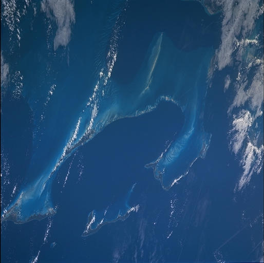
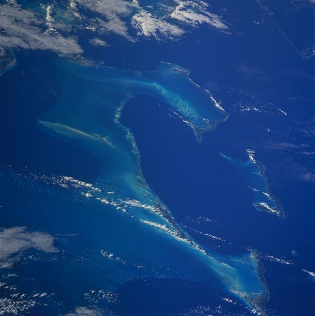
Image Caption: The high altitude of STS-103 enabled the crew to obtain this panoramic view of some of
the islands of the Bahamas. The Bahamas are an archipelago that comprises nearly 700
islands and cays, only 30 of which are inhabited. The Bahamas were created from
shallow water calcium carbonate deposits that have precipitated out of the water column
and grown over the highest elevations of the submerged Bahama banks. At least three
types of underwater communities exist here, soft coral and sponge reefs, sandy bottom
communities, and hard corals. Stresses to the reefs include overfishing, coastal
development and population growth, and poorly managed boating, diving, and increased
tourism.
