STS101-718-27
| NASA Photo ID | STS101-718-27 |
| Focal Length | 40mm |
| Date taken | 2000.05.27 |
| Time taken | 07:05:41 GMT |
Resolutions offered for this image:
1034 x 1024 pixels 2071 x 2048 pixels 4143 x 4096 pixels 517 x 512 pixels 1289 x 1292 pixels 399 x 400 pixels
1034 x 1024 pixels 2071 x 2048 pixels 4143 x 4096 pixels 517 x 512 pixels 1289 x 1292 pixels 399 x 400 pixels


Cloud masks available for this image:
Spacecraft nadir point: 29.8° N, 46.6° E
Photo center point: 27.5° N, 54.0° E
Photo center point by machine learning:
Photo center point: 27.5° N, 54.0° E
Photo center point by machine learning:
Nadir to Photo Center: East
Spacecraft Altitude: 203 nautical miles (376km)
Country or Geographic Name: | IRAN |
Features: | PAN-STR. OF HORMUZ, DUST |
| Features Found Using Machine Learning: | |
Cloud Cover Percentage: | 10 (1-10)% |
Sun Elevation Angle: | 65° |
Sun Azimuth: | 103° |
Camera: | Hasselblad |
Focal Length: | 40mm |
Camera Tilt: | High Oblique |
Format: | 5069: Kodak Elite 100S, E6 Reversal, Replaces Lumiere, Warmer in tone vs. Lumiere |
Film Exposure: | |
| Additional Information | |
| Width | Height | Annotated | Cropped | Purpose | Links |
|---|---|---|---|---|---|
| 1034 pixels | 1024 pixels | No | No | Download Image | |
| 2071 pixels | 2048 pixels | No | No | Download Image | |
| 4143 pixels | 4096 pixels | No | No | Download Image | |
| 517 pixels | 512 pixels | No | No | Download Image | |
| 1289 pixels | 1292 pixels | No | Photographic Highlights | Download Image | |
| 399 pixels | 400 pixels | No | Photographic Highlights | Download Image |
Download Packaged File
Download a Google Earth KML for this Image
View photo footprint information
Download a GeoTIFF for this photo
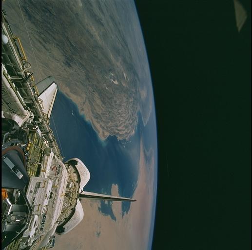
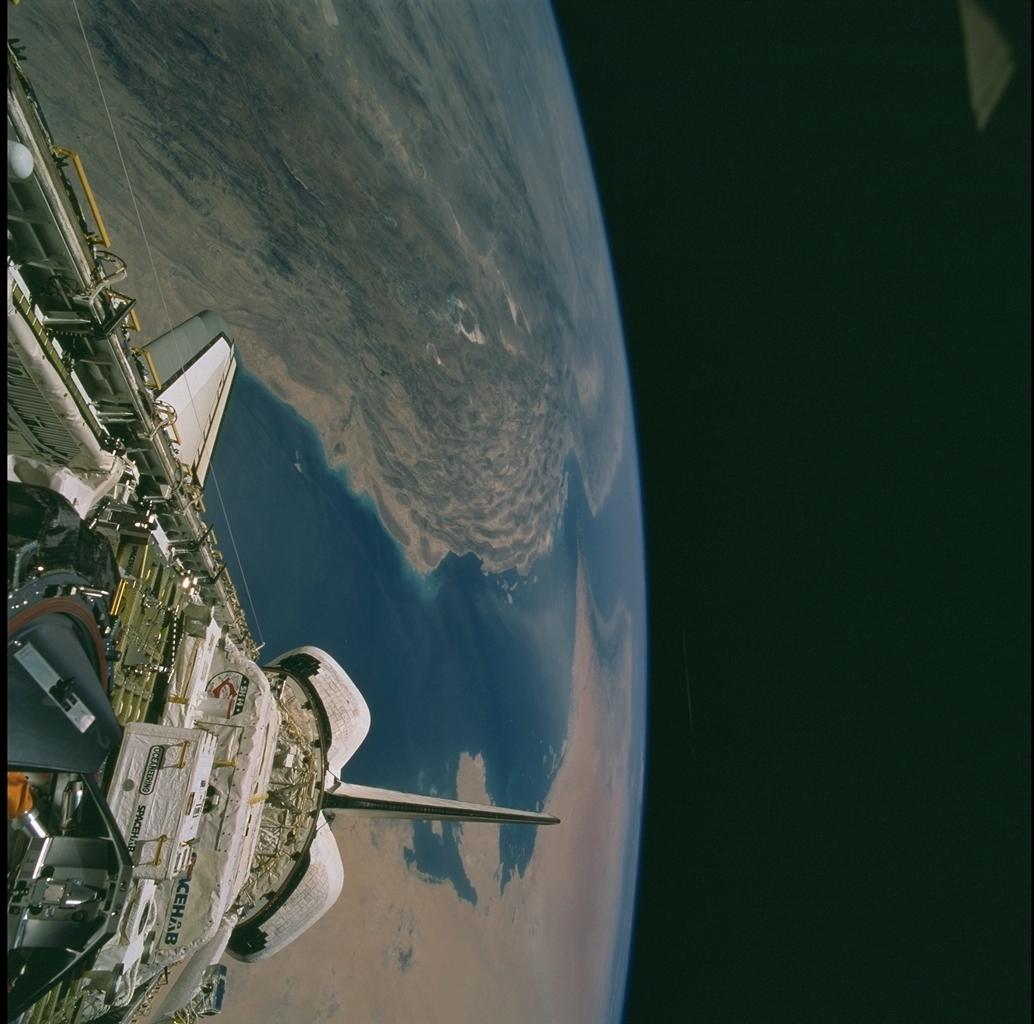
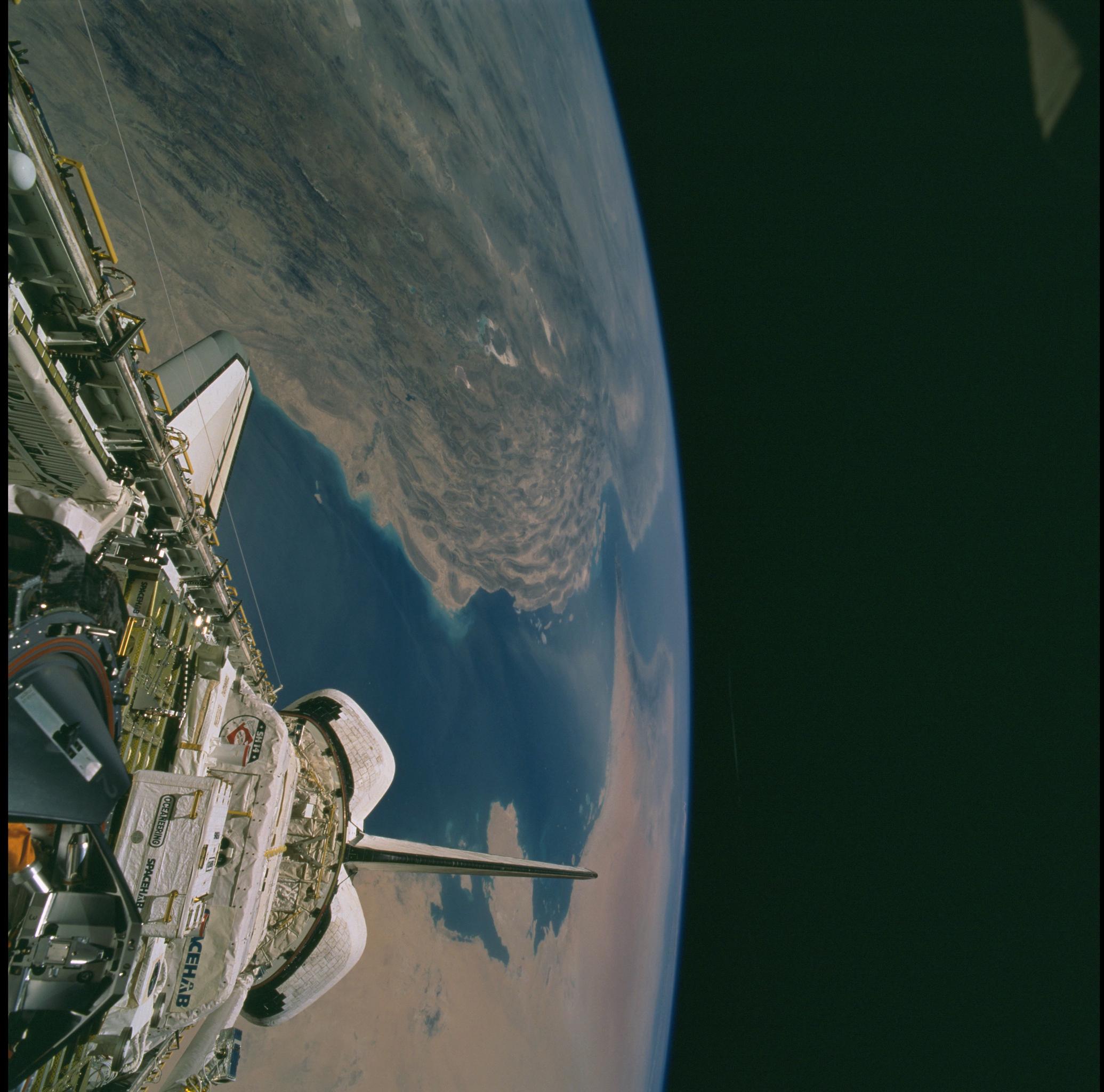
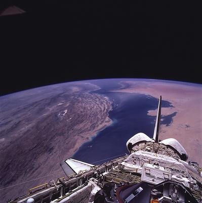
Image Caption: N. and S. Zagros Ranges & Persian Gulf
The lobate Qatar peninsula and Bahrain, on the southwestern shore of the
Persian Gulf, lie beyond the orbiter stabilizer in this southeastward
view. Along the northern Gulf coast are the folded mountain ranges of
Iran, where the contrasting structural styles in the Northern and
Southern Zagros ranges are clearly visible. Folds of the Northern
Zagros, at left just above the orbiter, are long and tight, whereas
those of the Southern Zagros are broader and less continuous. The
differing styles reflect the responses of different rock types to the
collision of the Arabian and Eurasian tectonic plates.
Arabia is moving northward and is descending beneath the Eurasian plate
margin, resulting in the crumpling of strata along the margin. The dark
rocks in the crescent along the Oman Peninsula (distant center) are
remnants of oceanic crust that were uplifted about 70 million years ago,
early in the collision of the two plates.
