STS100-703-46

| NASA Photo ID | STS100-703-46 |
| Focal Length | 250mm |
| Date taken | 2001.04.20 |
| Time taken | 11:16:47 GMT |
Resolutions offered for this image:
1110 x 1190 pixels 540 x 579 pixels 1031 x 1024 pixels 2063 x 2048 pixels 4127 x 4096 pixels 515 x 512 pixels 2536 x 2531 pixels 1268 x 1265 pixels 540 x 423 pixels 400 x 313 pixels
1110 x 1190 pixels 540 x 579 pixels 1031 x 1024 pixels 2063 x 2048 pixels 4127 x 4096 pixels 515 x 512 pixels 2536 x 2531 pixels 1268 x 1265 pixels 540 x 423 pixels 400 x 313 pixels


Cloud masks available for this image:
Spacecraft nadir point: 31.9° N, 31.3° E
Photo center point: 31.0° N, 32.0° E
Photo center point by machine learning:
Photo center point: 31.0° N, 32.0° E
Photo center point by machine learning:
Nadir to Photo Center: Southeast
Spacecraft Altitude: 136 nautical miles (252km)
Country or Geographic Name: | EGYPT |
Features: | SUEZ CANAL, PORT SAID |
| Features Found Using Machine Learning: | |
Cloud Cover Percentage: | 10 (1-10)% |
Sun Elevation Angle: | 62° |
Sun Azimuth: | 228° |
Camera: | Hasselblad |
Focal Length: | 250mm |
Camera Tilt: | 27 degrees |
Format: | 5069: Kodak Elite 100S, E6 Reversal, Replaces Lumiere, Warmer in tone vs. Lumiere |
Film Exposure: | |
| Additional Information | |
| Width | Height | Annotated | Cropped | Purpose | Links |
|---|---|---|---|---|---|
| 1110 pixels | 1190 pixels | Yes | Yes | NASA's Earth Observatory web site | Download Image |
| 540 pixels | 579 pixels | Yes | Yes | NASA's Earth Observatory web site | Download Image |
| 1031 pixels | 1024 pixels | No | No | Download Image | |
| 2063 pixels | 2048 pixels | No | No | Download Image | |
| 4127 pixels | 4096 pixels | No | No | Download Image | |
| 515 pixels | 512 pixels | No | No | Download Image | |
| 2536 pixels | 2531 pixels | No | No | Download Image | |
| 1268 pixels | 1265 pixels | No | No | Download Image | |
| 540 pixels | 423 pixels | Yes | Yes | NASA's Earth Observatory web site | Download Image |
| 400 pixels | 313 pixels | Yes | Yes | Photographic Highlights | Download Image |
Download Packaged File
Download a Google Earth KML for this Image
View photo footprint information
Download a GeoTIFF for this photo
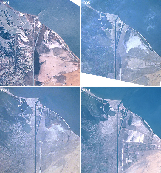
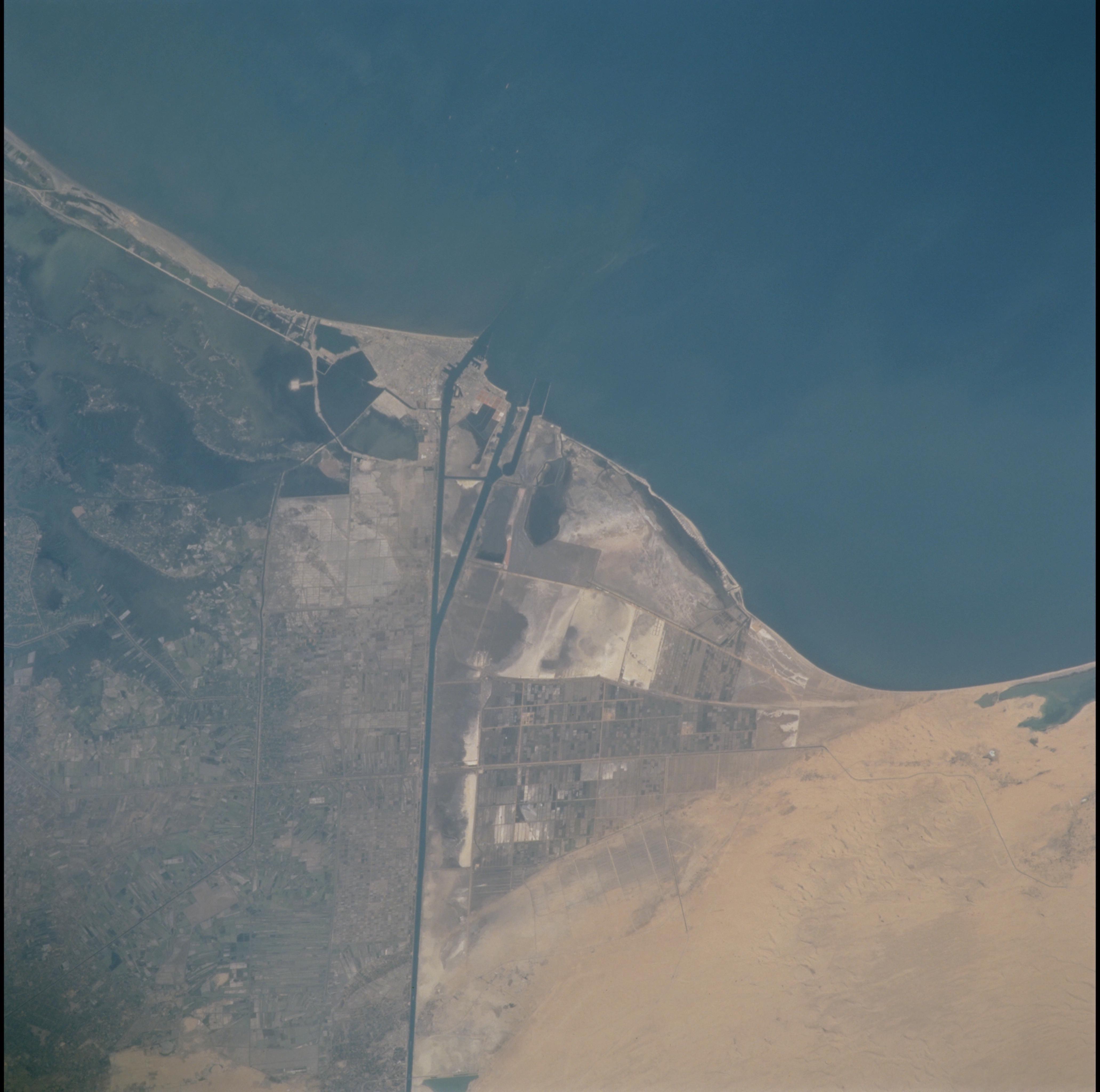
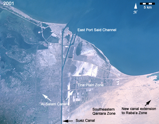
Image Caption: This time series of photographs of the Mediterranean coast near the Suez Canal (Images STS040-77-91, STS073-708-83, STS090-728-55, and STS100-703-46) shows ten years of changes associated with two of Egypt's "Mega" Development Projects. At the mouth of the canal, a large auxiliary channel has been formed as part of a new central hub port and industrial zone, known as the East Port-Said Project. Further south, the effects of the Al-Salam (El Salam or "Peace") Canal and North Sinai Agricultural Development Program can be seen as desert is converted to irrigated agriculture.
The Al-Salam Canal brings water from the Damietta Branch of the Nile, under the Suez Canal to the Sinai Peninsula. First, the project provided irrigation waters to the area west of the Suez Canal. In October 1997, the culvert under the Suez was completed and water became available for irrigation in Block 1, the Tina Plain Zone (50,000 acres). Fields soon began to appear.
The most recent photo, taken by the STS-100 crew in April 2001, shows a new extension of canals into the desert to the east. These canals will eventually feed irrigation in Block 3, the Raba'a Zone. Development of more fields can also be seen south of the Tina Plain Zone in an area called Block 2, the Southeastern Qantara Zone. Plans call for extending the canal by mid-2002 and irrigating a total of 620,000 acres. The cost of the project is estimated to exceed 7.5 billion Egyptian pounds (about $2 billion). Given the scarcity of water resources in the region and the costs involved, it is not surprising that the project is controversial within and outside Egypt.
