STS099-749-89
| NASA Photo ID | STS099-749-89 |
| Focal Length | 100mm |
| Date taken | 2000.02.__ |
| Time taken | GMT |
Resolutions offered for this image:
1031 x 1024 pixels 2063 x 2048 pixels 4127 x 4096 pixels 515 x 512 pixels
1031 x 1024 pixels 2063 x 2048 pixels 4127 x 4096 pixels 515 x 512 pixels


Cloud masks available for this image:
Spacecraft nadir point:
Photo center point: 57.0° N, 157.5° W
Photo center point by machine learning:
Photo center point: 57.0° N, 157.5° W
Photo center point by machine learning:
Nadir to Photo Center:
Spacecraft Altitude: nautical miles (0km)
Country or Geographic Name: | USA-ALASKA |
Features: | ANIAKCHAK CRATER, SHUTTLE |
| Features Found Using Machine Learning: | |
Cloud Cover Percentage: | 25 (11-25)% |
Sun Elevation Angle: | ° |
Sun Azimuth: | ° |
Camera: | Hasselblad |
Focal Length: | 100mm |
Camera Tilt: | |
Format: | 5069: Kodak Elite 100S, E6 Reversal, Replaces Lumiere, Warmer in tone vs. Lumiere |
Film Exposure: | |
| Additional Information | |
| Width | Height | Annotated | Cropped | Purpose | Links |
|---|---|---|---|---|---|
| 1031 pixels | 1024 pixels | No | No | Download Image | |
| 2063 pixels | 2048 pixels | No | No | Download Image | |
| 4127 pixels | 4096 pixels | No | No | Download Image | |
| 515 pixels | 512 pixels | No | No | Download Image |
Download Packaged File
Download a Google Earth KML for this Image
View photo footprint information
Download a GeoTIFF for this photo
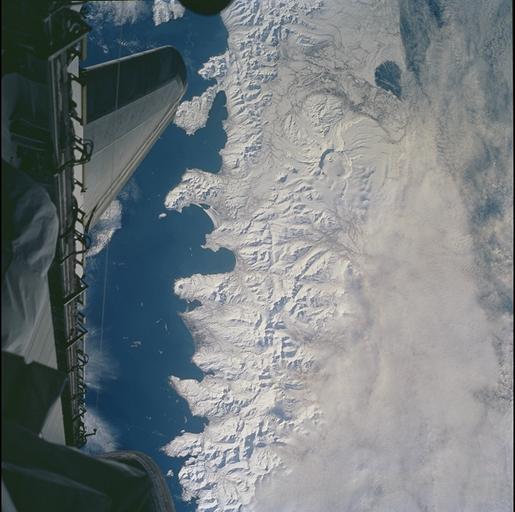
Image Caption: Alaska Peninsula, Alaska, USA
The Alaska Peninsula and Aleutian Islands form a long arc that intervenes
between the Bering Sea and the northern Pacific Ocean. This view is of the
snowy south coast of the peninsula, from Chignik Bay and Cape Kumliun (on the
triangular peninsula) northeastward to Chiginagak Bay and David Island. Port
Heiden is the darker area of little ice on the north coast. Within the rim of the
Aniakchak volcanic crater (4450 ft at highest point) the frozen waters of Surprise
Lake are visible.
The North American and Pacific tectonic plates are converging in this region at a
rate of about 5 cm/yr. The Pacific plate descends beneath North America,
producing a deep trench along the south coast; the Aleutian Trench reaches
depths greater than 25,000 ft. In such regions (subduction zones) volcanoes
form on the overriding plate -- the North American plate in this instance;
Aniakchak is one of the many young volcanoes in this arc.
