STS098-E-5327

| NASA Photo ID | STS098-E-5327 |
| Focal Length | mm |
| Date taken | 2001.02.16 |
| Time taken | 19:42:19 GMT |
Cloud masks available for this image:
Spacecraft nadir point: 33.0° N, 75.6° W
Photo center point: 28.5° N, 80.5° W
Photo center point by machine learning:
Photo center point: 28.5° N, 80.5° W
Photo center point by machine learning:
Nadir to Photo Center: Southwest
Spacecraft Altitude: 202 nautical miles (374km)
Country or Geographic Name: | USA-FLORIDA |
Features: | KENNEDY SPACE CENTER |
| Features Found Using Machine Learning: | |
Cloud Cover Percentage: | 10 (1-10)% |
Sun Elevation Angle: | 33° |
Sun Azimuth: | 224° |
Camera: | |
Focal Length: | mm |
Camera Tilt: | High Oblique |
Format: | 3060E: 3060 x 2036 pixel CCD, RGBG array |
Film Exposure: | |
| Additional Information | |
| Width | Height | Annotated | Cropped | Purpose | Links |
|---|---|---|---|---|---|
| 3040 pixels | 2064 pixels | No | No | Download Image | |
| 640 pixels | 434 pixels | No | No | Download Image |
Download Packaged File
Download a Google Earth KML for this Image
View photo footprint information
Download a GeoTIFF for this photo
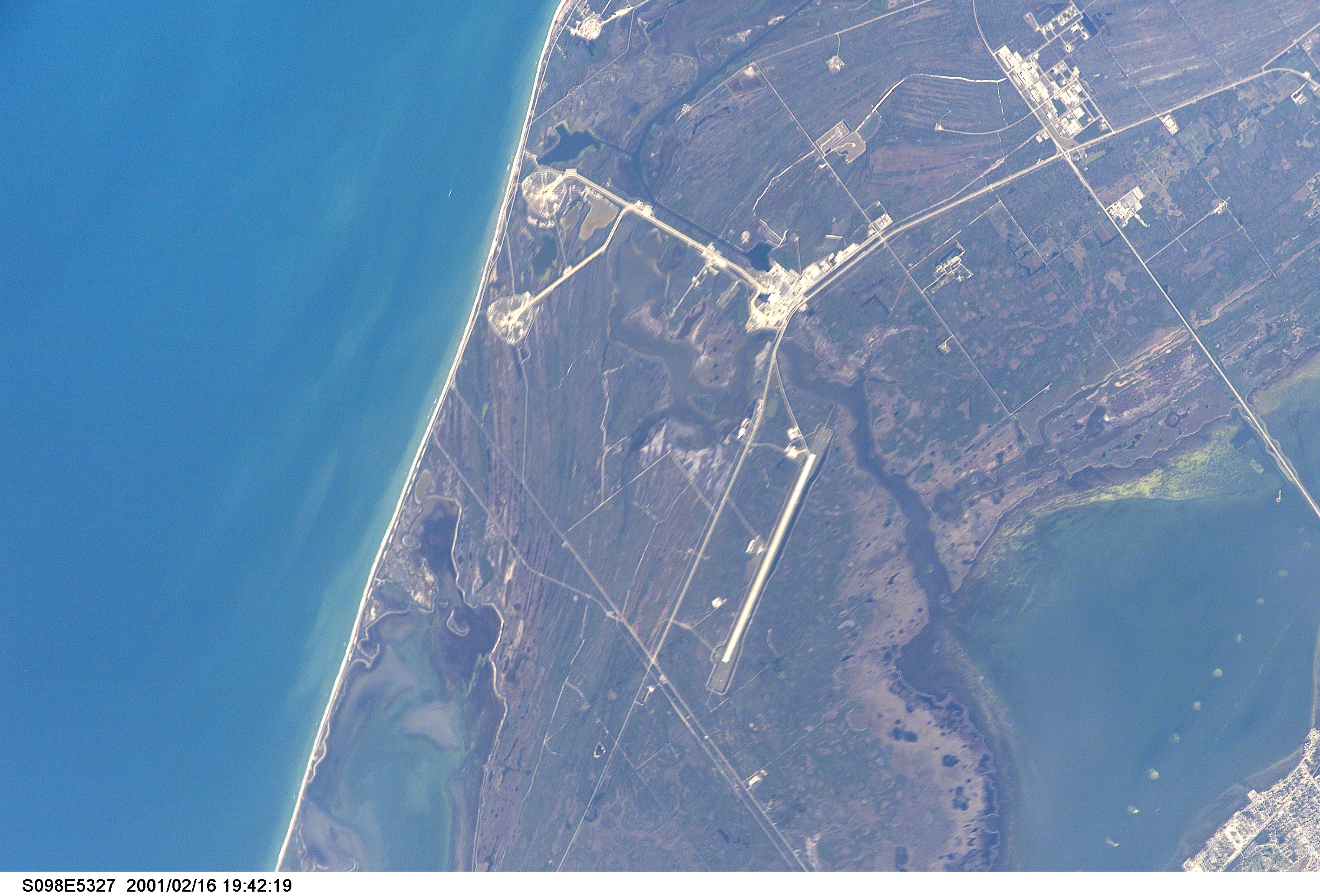
Image Caption: John F. Kennedy Space Center, Florida
Located on Merritt Island along the east coast of Florida, two of NASA's Space Shuttle launch sites, roughly oval-shaped area, are visible (slightly above and left of center). The launch pads are connected by specially prepared roadway to the Vehicle Assembly Building (highly reflective area slightly above and right of center). The Vehicle Assembly Building also has a roadway that connects with a narrow, linear, highly reflective feature north of the VAB site, the Shuttle Landing Facility. This runway serves as the primary landing site for all returning Space Shuttle missions. Several roads (light-colored linear features) can be identified as they cross the flat, generally swampy and vegetated terrain in and around the Kennedy Space Center. Besides the Atlantic Ocean (left) two other recognizable water features can be discriminated: the southern end of Mosquito Lagoon (center lower left) and a small segment of the Banana River (lower right corner of the image). The large light-colored area near the upper right corner of the image is the Kennedy Space Center Industrial Area.
Located on Merritt Island along the east coast of Florida, two of NASA's Space Shuttle launch sites, roughly oval-shaped area, are visible (slightly above and left of center). The launch pads are connected by specially prepared roadway to the Vehicle Assembly Building (highly reflective area slightly above and right of center). The Vehicle Assembly Building also has a roadway that connects with a narrow, linear, highly reflective feature north of the VAB site, the Shuttle Landing Facility. This runway serves as the primary landing site for all returning Space Shuttle missions. Several roads (light-colored linear features) can be identified as they cross the flat, generally swampy and vegetated terrain in and around the Kennedy Space Center. Besides the Atlantic Ocean (left) two other recognizable water features can be discriminated: the southern end of Mosquito Lagoon (center lower left) and a small segment of the Banana River (lower right corner of the image). The large light-colored area near the upper right corner of the image is the Kennedy Space Center Industrial Area.
