STS098-712-29
| NASA Photo ID | STS098-712-29 |
| Focal Length | 100mm |
| Date taken | 2001.02.18 |
| Time taken | 14:42:59 GMT |
Resolutions offered for this image:
540 x 532 pixels 1031 x 1024 pixels 2063 x 2048 pixels 4127 x 4096 pixels 515 x 512 pixels 1297 x 1290 pixels 400 x 398 pixels
540 x 532 pixels 1031 x 1024 pixels 2063 x 2048 pixels 4127 x 4096 pixels 515 x 512 pixels 1297 x 1290 pixels 400 x 398 pixels


Cloud masks available for this image:
Spacecraft nadir point: 39.0° N, 2.7° W
Photo center point: 36.0° N, 5.5° W
Photo center point by machine learning:
Photo center point: 36.0° N, 5.5° W
Photo center point by machine learning:
Nadir to Photo Center: Southwest
Spacecraft Altitude: 198 nautical miles (367km)
Country or Geographic Name: | SPAIN |
Features: | STRAIT OF GIBRALTAR, SUNGLINT |
| Features Found Using Machine Learning: | |
Cloud Cover Percentage: | 10 (1-10)% |
Sun Elevation Angle: | 30° |
Sun Azimuth: | 220° |
Camera: | Hasselblad |
Focal Length: | 100mm |
Camera Tilt: | 51 degrees |
Format: | 5069: Kodak Elite 100S, E6 Reversal, Replaces Lumiere, Warmer in tone vs. Lumiere |
Film Exposure: | |
| Additional Information | |
| Width | Height | Annotated | Cropped | Purpose | Links |
|---|---|---|---|---|---|
| 540 pixels | 532 pixels | Yes | Yes | Earth From Space collection | Download Image |
| 1031 pixels | 1024 pixels | No | No | Download Image | |
| 2063 pixels | 2048 pixels | No | No | Download Image | |
| 4127 pixels | 4096 pixels | No | No | Download Image | |
| 515 pixels | 512 pixels | No | No | Download Image | |
| 1297 pixels | 1290 pixels | No | No | Download Image | |
| 400 pixels | 398 pixels | No | No | Photographic Highlights | Download Image |
Download Packaged File
Download a Google Earth KML for this Image
View photo footprint information
Download a GeoTIFF for this photo
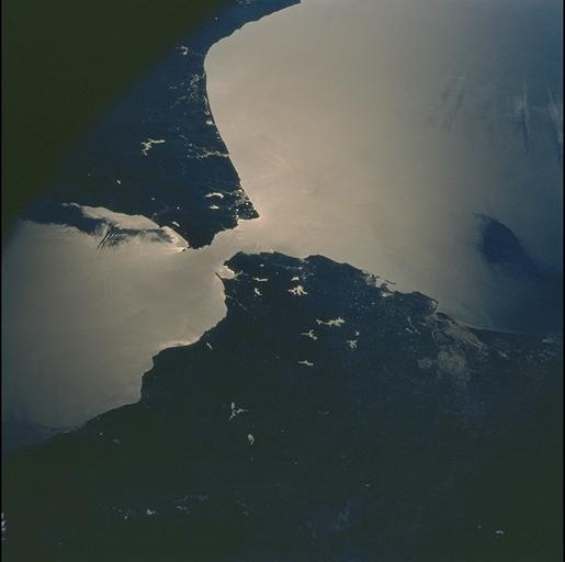
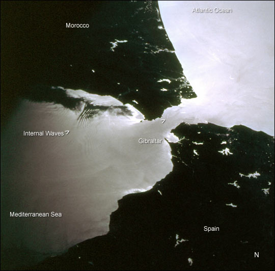
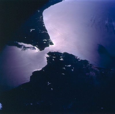
Image Caption: This photograph was taken by the STS-98 astronaut crew as they passed over the western Mediterranean region near sunset on February 19, 2001. Two packets of tidally-generated internal waves are highlighted by sun glinting off the surface waters in the Strait of Gibraltar. The older packet (labeled) contains at least 14 waves, which can be counted like tree rings. A younger group is forming near the middle of the strait (marked by the carat south of Gibraltar). The waves are generated as a diurnal tidal pulse flows over the shallow Camarinal Sill at Gibraltar. The waves flow eastward, refract around coastal features; can be traced for as much as 150 km, and sometimes create interference patterns with refracted waves.
Surface water patterns can be observed by astronauts in low-Earth orbit in the sunglint: the sun reflects and is differentially scattered off the water surface. The strength of the reflection is determined by the surfactant layer, which can dampen capillary waves and change the surface texture of the water. Different types of near-surface water structures act to locally concentrate or thin the surfactant layer, which, depending on the instantaneous geometry of the Sun, the Earth and the spacecraft, show up as brighter and darker regions on the water. Although sunglint effectively masks true water color, the sunglint patterns reveal surface water dynamics like eddies, current boundaries and even deeper water features like internal waves that are otherwise invisible. Sunglint also effectively traces land-water boundaries. The bright regions in Spain and Morocco are reservoirs, rivers and lakes.
Surface water patterns can be observed by astronauts in low-Earth orbit in the sunglint: the sun reflects and is differentially scattered off the water surface. The strength of the reflection is determined by the surfactant layer, which can dampen capillary waves and change the surface texture of the water. Different types of near-surface water structures act to locally concentrate or thin the surfactant layer, which, depending on the instantaneous geometry of the Sun, the Earth and the spacecraft, show up as brighter and darker regions on the water. Although sunglint effectively masks true water color, the sunglint patterns reveal surface water dynamics like eddies, current boundaries and even deeper water features like internal waves that are otherwise invisible. Sunglint also effectively traces land-water boundaries. The bright regions in Spain and Morocco are reservoirs, rivers and lakes.
