STS097-711-69
| NASA Photo ID | STS097-711-69 |
| Focal Length | 250mm |
| Date taken | 2000.12.10 |
| Time taken | 12:54:08 GMT |
Resolutions offered for this image:
1031 x 1024 pixels 2063 x 2048 pixels 4127 x 4096 pixels 640 x 640 pixels 515 x 512 pixels 4096 x 4096 pixels 1266 x 1274 pixels
1031 x 1024 pixels 2063 x 2048 pixels 4127 x 4096 pixels 640 x 640 pixels 515 x 512 pixels 4096 x 4096 pixels 1266 x 1274 pixels


Cloud masks available for this image:
Spacecraft nadir point: 33.6° S, 19.3° E
Photo center point: 33.5° S, 19.0° E
Photo center point by machine learning:
Photo center point: 33.5° S, 19.0° E
Photo center point by machine learning:
Nadir to Photo Center: West
Spacecraft Altitude: 193 nautical miles (357km)
Country or Geographic Name: | REPUBLIC SOUTH AFRICA |
Features: | CAPE TOWN |
| Features Found Using Machine Learning: | |
Cloud Cover Percentage: | 10 (1-10)% |
Sun Elevation Angle: | 58° |
Sun Azimuth: | 280° |
Camera: | Hasselblad |
Focal Length: | 250mm |
Camera Tilt: | 6 degrees |
Format: | 5069: Kodak Elite 100S, E6 Reversal, Replaces Lumiere, Warmer in tone vs. Lumiere |
Film Exposure: | |
| Additional Information | |
| Width | Height | Annotated | Cropped | Purpose | Links |
|---|---|---|---|---|---|
| 1031 pixels | 1024 pixels | No | No | Download Image | |
| 2063 pixels | 2048 pixels | No | No | Download Image | |
| 4127 pixels | 4096 pixels | No | No | Download Image | |
| 640 pixels | 640 pixels | No | No | Photographic Highlights | Download Image |
| 515 pixels | 512 pixels | No | No | Download Image | |
| 4096 pixels | 4096 pixels | No | No | Public Affairs Office (PAO) | Download Image |
| 1266 pixels | 1274 pixels | No | No | Download Image |
Download Packaged File
Download a Google Earth KML for this Image
View photo footprint information
Download a GeoTIFF for this photo
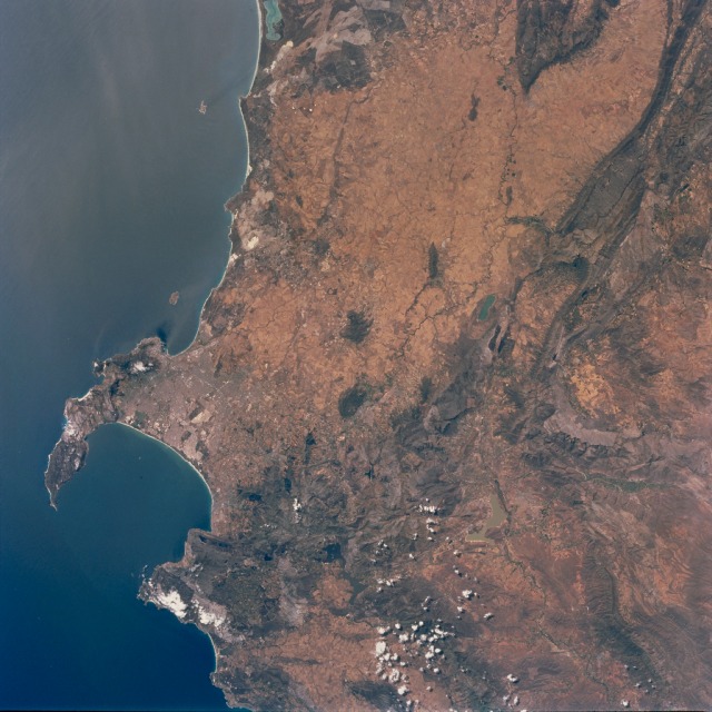
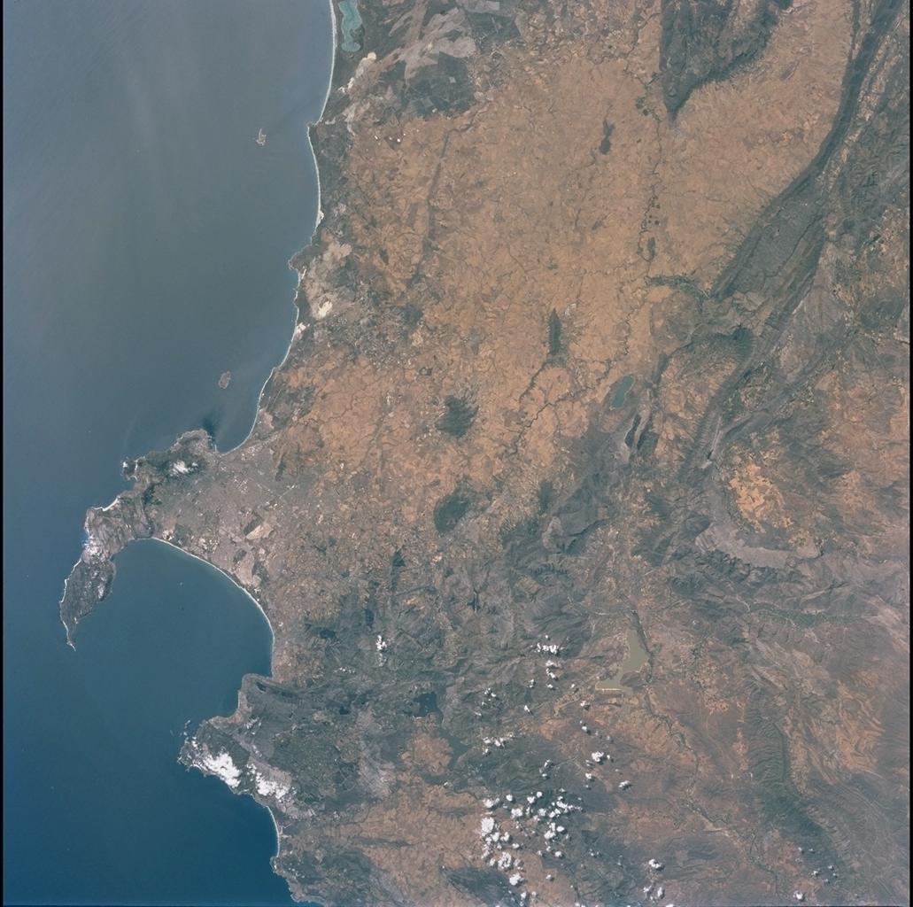
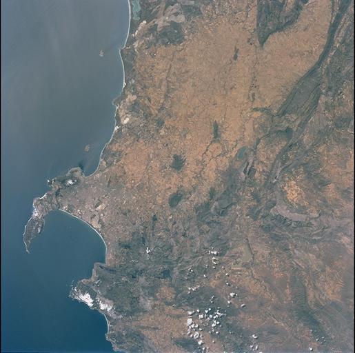
Image Caption: Cape Town, Western Cape Province, Republic of South Africa
The capital and largest city of Western Cape Province, Cape Town (1995 population in the urban and suburban area over 1.9 million), is visible between False Bay (large, U-shaped bay) and a smaller bay along the Atlantic coast of the peninsula. Within the urban built up area some of the infrastructure of Cape Town, including the city center and the harbor and waterfront facilities, can be identified near the small bay (near the middle left edge of the image). Table Mountain elevation of 3563 feet (1086 meters above sea level) separates the city center (north of the mountain) from the southern suburbs of Cape Town. The Cape of Good Hope, long famous as the gateway from the Atlantic Ocean to the Indian Ocean, is located at the southern tip of the claw-shaped peninsula. False Bay is a popular recreational region for the local residents of the greater Cape Town region, as well as a tourist attraction for people who live beyond the borders of South Africa. The lighter-colored terrain, mainly north of Cape Town, shows a landscape of large, cultivated field patterns. These coastal plains are separated from the interior by a chain of folded mountain ranges that include the Cedarberg (dark,linear, north/south aligned feature in the upper right corner) and the more complex, folded Herrivierberge Mountains (dark structure, right middle) that are located northeast of Cape Town.
The capital and largest city of Western Cape Province, Cape Town (1995 population in the urban and suburban area over 1.9 million), is visible between False Bay (large, U-shaped bay) and a smaller bay along the Atlantic coast of the peninsula. Within the urban built up area some of the infrastructure of Cape Town, including the city center and the harbor and waterfront facilities, can be identified near the small bay (near the middle left edge of the image). Table Mountain elevation of 3563 feet (1086 meters above sea level) separates the city center (north of the mountain) from the southern suburbs of Cape Town. The Cape of Good Hope, long famous as the gateway from the Atlantic Ocean to the Indian Ocean, is located at the southern tip of the claw-shaped peninsula. False Bay is a popular recreational region for the local residents of the greater Cape Town region, as well as a tourist attraction for people who live beyond the borders of South Africa. The lighter-colored terrain, mainly north of Cape Town, shows a landscape of large, cultivated field patterns. These coastal plains are separated from the interior by a chain of folded mountain ranges that include the Cedarberg (dark,linear, north/south aligned feature in the upper right corner) and the more complex, folded Herrivierberge Mountains (dark structure, right middle) that are located northeast of Cape Town.
