STS096-724-53

| NASA Photo ID | STS096-724-53 |
| Focal Length | 40mm |
| Date taken | 1999.06.02 |
| Time taken | 08:28:35 GMT |
Resolutions offered for this image:
1029 x 1024 pixels 2059 x 2048 pixels 4119 x 4096 pixels 514 x 512 pixels
1029 x 1024 pixels 2059 x 2048 pixels 4119 x 4096 pixels 514 x 512 pixels


Cloud masks available for this image:
Spacecraft nadir point: 37.0° N, 38.5° E
Photo center point: 31.0° N, 33.5° E
Photo center point by machine learning:
Photo center point: 31.0° N, 33.5° E
Photo center point by machine learning:
Nadir to Photo Center: Southwest
Spacecraft Altitude: 204 nautical miles (378km)
Country or Geographic Name: | EGYPT |
Features: | PAN-NILE, SYRIAN DESERT |
| Features Found Using Machine Learning: | |
Cloud Cover Percentage: | 10 (1-10)% |
Sun Elevation Angle: | 71° |
Sun Azimuth: | 137° |
Camera: | Hasselblad |
Focal Length: | 40mm |
Camera Tilt: | High Oblique |
Format: | 5069: Kodak Elite 100S, E6 Reversal, Replaces Lumiere, Warmer in tone vs. Lumiere |
Film Exposure: | Out of Focus |
| Additional Information | |
| Width | Height | Annotated | Cropped | Purpose | Links |
|---|---|---|---|---|---|
| 1029 pixels | 1024 pixels | No | No | Download Image | |
| 2059 pixels | 2048 pixels | No | No | Download Image | |
| 4119 pixels | 4096 pixels | No | No | Download Image | |
| 514 pixels | 512 pixels | No | No | Download Image |
Download Packaged File
Download a Google Earth KML for this Image
View photo footprint information
Download a GeoTIFF for this photo
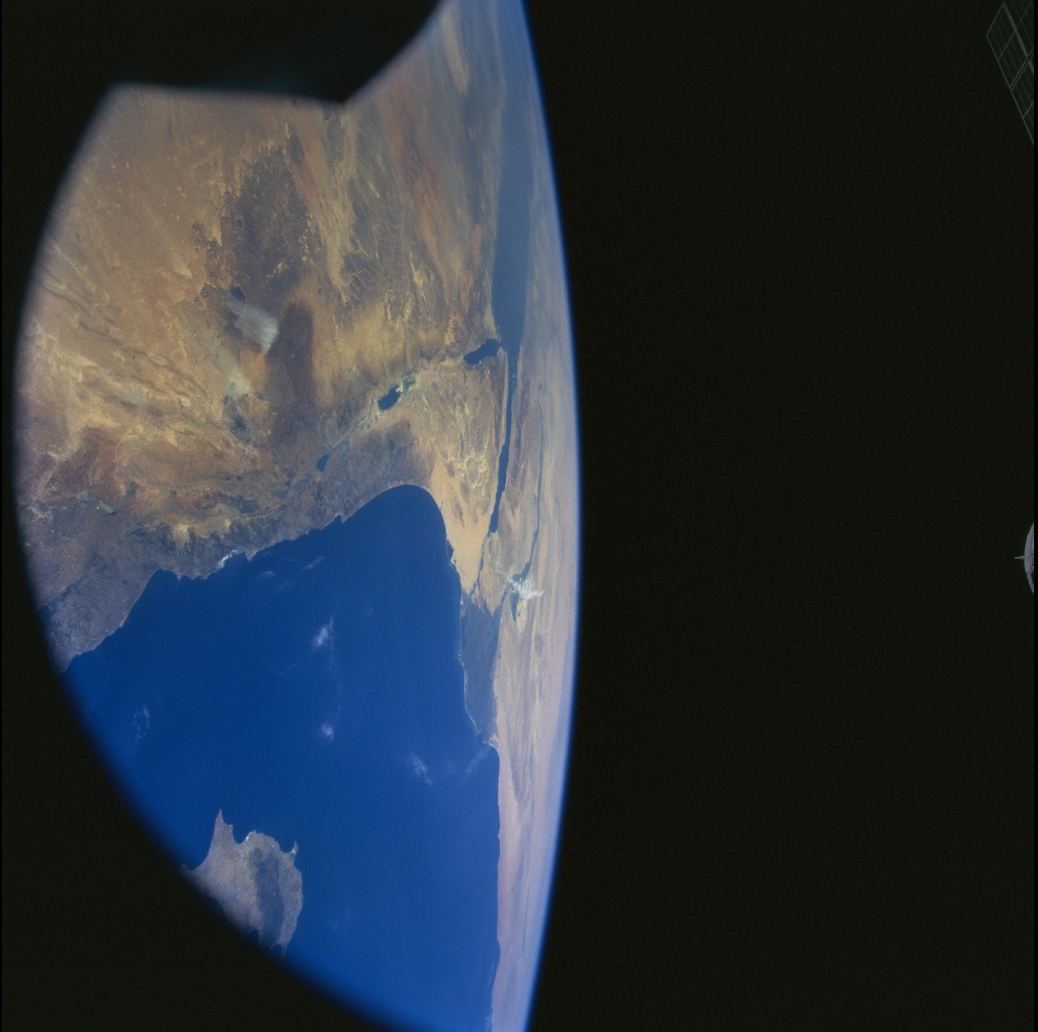
Image Caption: The Sinai Peninsula of Egypt is centered in this southwestward view; the Red Sea, Gulf
of Suez, Suez Canal, and Nile River delta lie beyond. Bahrat Hims, Syria, is the pale blue
lake near bottom center. The Gulf of Aqaba, Dead Sea, and the Sea of Galilee define the
eastern margin of the Peninsula. The city of Haifa is on the peninsula directly west of the
Sea of Galilee; Beirut, Lebanon occupies the next prominent peninsula to the north.
The Dead Sea fault zone marks the boundary between the African and Arabian
tectonic plates; Sinai Peninsula is the northeastern tip of the African plate, which is being
pulled apart by the Red Sea rift. This is one of the best photos to date of the region where
the Dead Sea fault zone splays to the northeast in Syria. Those northeasterly faults and
the East Anatolian fault zone define the margin between the Arabian and Eurasian plates.
