STS096-714-53
| NASA Photo ID | STS096-714-53 |
| Focal Length | 250mm |
| Date taken | 1999.06.04 |
| Time taken | 08:02:31 GMT |
Resolutions offered for this image:
1025 x 1024 pixels 2049 x 2048 pixels 4098 x 4096 pixels 512 x 512 pixels
1025 x 1024 pixels 2049 x 2048 pixels 4098 x 4096 pixels 512 x 512 pixels


Cloud masks available for this image:
Spacecraft nadir point: 47.5° N, 10.2° E
Photo center point: 46.0° N, 8.5° E
Photo center point by machine learning:
Photo center point: 46.0° N, 8.5° E
Photo center point by machine learning:
Nadir to Photo Center: Southwest
Spacecraft Altitude: 211 nautical miles (391km)
Country or Geographic Name: | ITALY |
Features: | LAKE MAGGIORE |
| Features Found Using Machine Learning: | |
Cloud Cover Percentage: | 15 (11-25)% |
Sun Elevation Angle: | 44° |
Sun Azimuth: | 105° |
Camera: | Hasselblad |
Focal Length: | 250mm |
Camera Tilt: | 33 degrees |
Format: | 5069: Kodak Elite 100S, E6 Reversal, Replaces Lumiere, Warmer in tone vs. Lumiere |
Film Exposure: | Normal |
| Additional Information | |
| Width | Height | Annotated | Cropped | Purpose | Links |
|---|---|---|---|---|---|
| 1025 pixels | 1024 pixels | No | No | Download Image | |
| 2049 pixels | 2048 pixels | No | No | Download Image | |
| 4098 pixels | 4096 pixels | No | No | Download Image | |
| 512 pixels | 512 pixels | No | No | Download Image |
Download Packaged File
Download a Google Earth KML for this Image
View photo footprint information
Download a GeoTIFF for this photo
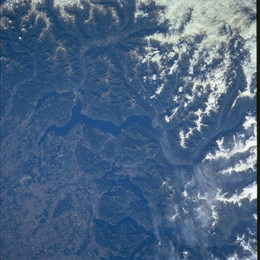
Image Caption: The slopes of the Alps are forested and appear green, whereas the
valley floor appears generally gray due to its dense urban landscapes
(lower left). The valley and all the lakes in the view have been
carved by a succession of glacier advances during the ice ages of the
past 2 million years. The largest lake (center) is Lake Maggiore,
ringed by the snowcapped Alps in Switzerland (right side and top of
the view). Some of the highest peaks reach almost 3000m (midway down
the right side of the view). The major transalpine St. Gotthard
railway, joining Milan and Zurich, enters the view along the largest
valley (Valle Levantina, right-which becomes Lake Maggiore). The next
lake east is smaller Lake Lugano. "A great stone dam ... built ... to
carry the railway" can be seen crossing L. Lugano. Lake Como appears
at the bottom of the view. The railroad passes through the town of
Como at the downstream end of Lake Como before heading southeast
across the valley floor to Milan (just outside the bottom-left corner
of the view). The large regional Malpensa Airport appears lower left.
