STS096-701-25
| NASA Photo ID | STS096-701-25 |
| Focal Length | 250mm |
| Date taken | 1999.05.29 |
| Time taken | 12:01:33 GMT |
Resolutions offered for this image:
1028 x 1024 pixels 2050 x 2048 pixels 4101 x 4096 pixels 514 x 512 pixels
1028 x 1024 pixels 2050 x 2048 pixels 4101 x 4096 pixels 514 x 512 pixels


Cloud masks available for this image:
Spacecraft nadir point: 42.0° N, 89.8° W
Photo center point: 43.5° N, 78.5° W
Photo center point by machine learning:
Photo center point: 43.5° N, 78.5° W
Photo center point by machine learning:
Nadir to Photo Center: East
Spacecraft Altitude: 204 nautical miles (378km)
Country or Geographic Name: | USA-NEW YORK |
Features: | PAN-L. ONTARIO, SUNGLINT |
| Features Found Using Machine Learning: | |
Cloud Cover Percentage: | 20 (11-25)% |
Sun Elevation Angle: | 15° |
Sun Azimuth: | 74° |
Camera: | Hasselblad |
Focal Length: | 250mm |
Camera Tilt: | High Oblique |
Format: | 5069: Kodak Elite 100S, E6 Reversal, Replaces Lumiere, Warmer in tone vs. Lumiere |
Film Exposure: | Under Exposed |
| Additional Information | |
| Width | Height | Annotated | Cropped | Purpose | Links |
|---|---|---|---|---|---|
| 1028 pixels | 1024 pixels | No | No | Download Image | |
| 2050 pixels | 2048 pixels | No | No | Download Image | |
| 4101 pixels | 4096 pixels | No | No | Download Image | |
| 514 pixels | 512 pixels | No | No | Download Image |
Download Packaged File
Download a Google Earth KML for this Image
View photo footprint information
Download a GeoTIFF for this photo
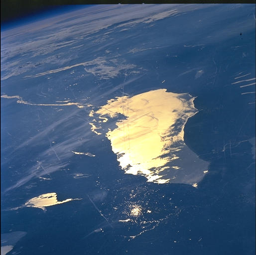
Image Caption: Lake Ontario, the smallest of the Great Lakes, as it appeared to the
STS-96 crew in low light and partial sunglint. Lake Ontario
discharges into the Saint Lawrence river which flows northeast towards
the Atlantic. Lake Champlain also shows partial sunglint
east-northeast of Lake Ontario. The thin white lines in the
photograph are contrails from some of the heavy air traffic in this
eastern corridor.
