STS095-721-AT

| NASA Photo ID | STS095-721-AT |
| Focal Length | 250mm |
| Date taken | 1998.__.__ |
| Time taken | GMT |
Resolutions offered for this image:
4096 x 4096 pixels 640 x 640 pixels 1284 x 1283 pixels 514 x 513 pixels
4096 x 4096 pixels 640 x 640 pixels 1284 x 1283 pixels 514 x 513 pixels

Cloud masks available for this image:
Spacecraft nadir point:
Photo center point: 21.0° N, 95.0° E
Photo center point by machine learning:
Photo center point: 21.0° N, 95.0° E
Photo center point by machine learning:
Nadir to Photo Center:
Spacecraft Altitude: nautical miles (0km)
Country or Geographic Name: | MYANMAR (BURMA) |
Features: | CHINDWIN R., ARAKAN HILLS |
| Features Found Using Machine Learning: | |
Cloud Cover Percentage: | 5 (1-10)% |
Sun Elevation Angle: | ° |
Sun Azimuth: | ° |
Camera: | Hasselblad |
Focal Length: | 250mm |
Camera Tilt: | Low Oblique |
Format: | 5069: Kodak Elite 100S, E6 Reversal, Replaces Lumiere, Warmer in tone vs. Lumiere |
Film Exposure: | Normal |
| Additional Information | |
| Width | Height | Annotated | Cropped | Purpose | Links |
|---|---|---|---|---|---|
| 4096 pixels | 4096 pixels | No | No | Earth From Space collection | Download Image |
| 640 pixels | 640 pixels | No | No | Earth From Space collection | Download Image |
| 1284 pixels | 1283 pixels | No | No | Download Image | |
| 514 pixels | 513 pixels | No | No | Download Image |
Download Packaged File
Download a Google Earth KML for this Image
View photo footprint information
Download a GeoTIFF for this photo
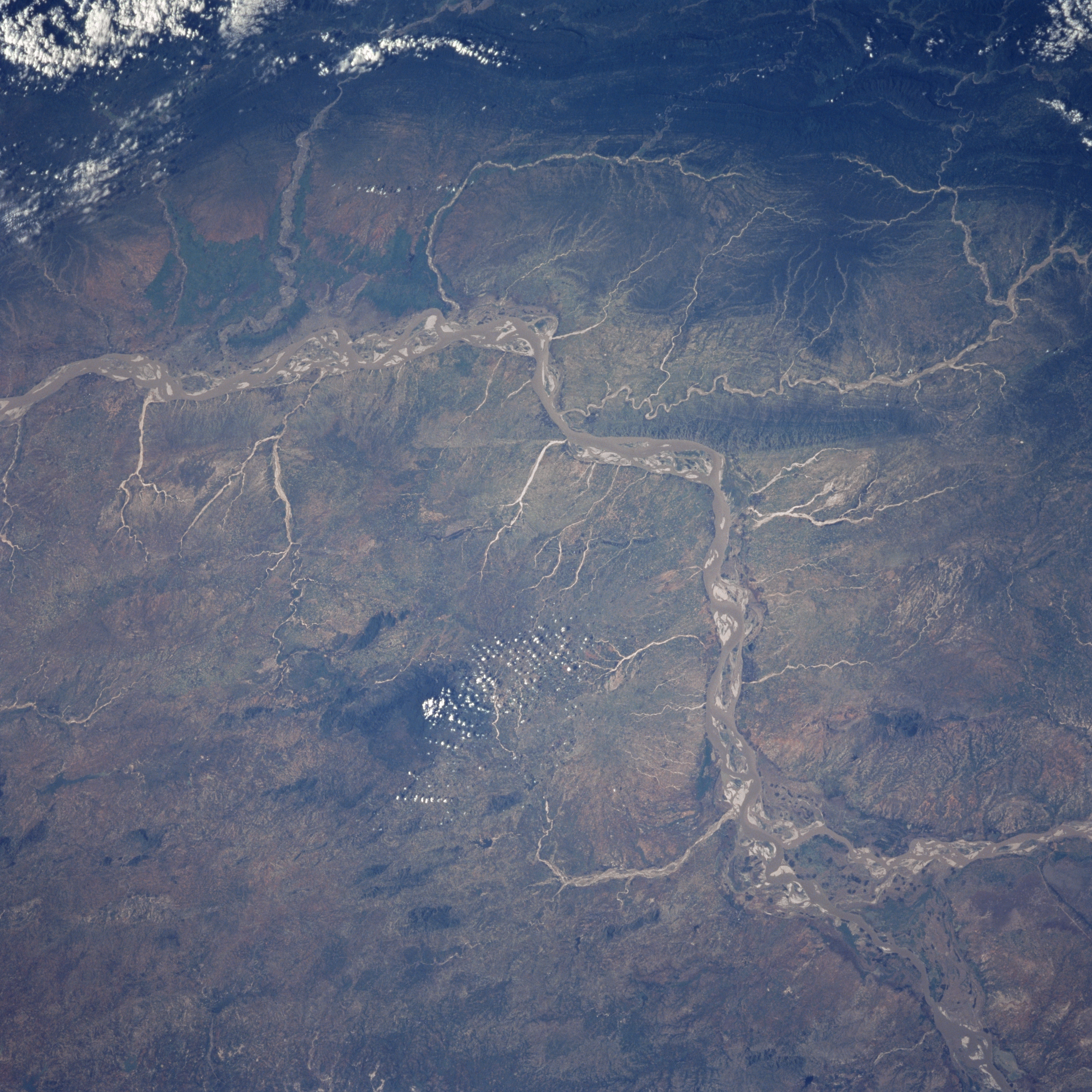
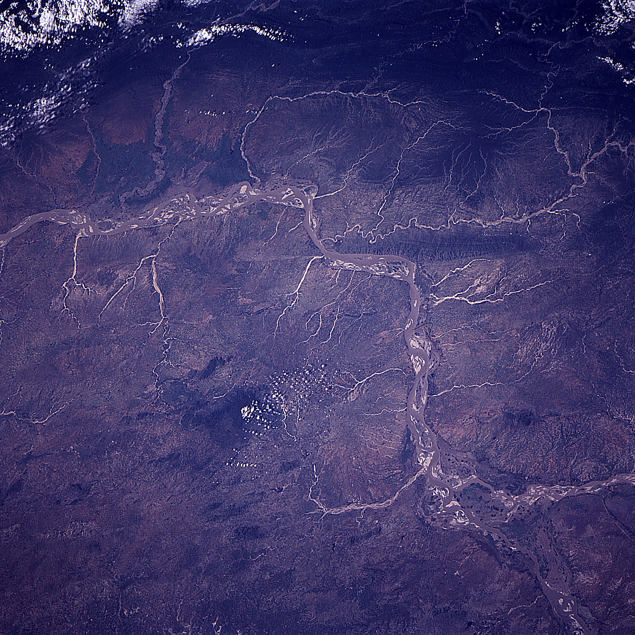
Image Caption: STS095-721-0AT Irrawaddy River Basin, Myanmar November 1998
The Irrawaddy River, the chief river of Myanmar (Burma), enters the scene at the bottom right. The river flows in a generally southwest direction before turning to the south and exiting the scene midway between the upper left and center left of the view. In this scene, numerous sandbars are visible in the main river channel. The Irrawaddy's chief tributary, the Chindwin River, is discernible entering the Irrawaddy in the bottom right portion of the image. The Chindwin River is 550 miles (885km) long and rises in the Kumon Range in northern Myanmar. The dark area to the south of the Irrawaddy and just to the left of center of the image is the 5080 Foot (1518 meters) Popa Mountain, an extinct volcano. At the top of the image, many small streams can be seen emptying into the Irrawaddy from the forested Arakan Mountain Range.
The Irrawaddy River, the chief river of Myanmar (Burma), enters the scene at the bottom right. The river flows in a generally southwest direction before turning to the south and exiting the scene midway between the upper left and center left of the view. In this scene, numerous sandbars are visible in the main river channel. The Irrawaddy's chief tributary, the Chindwin River, is discernible entering the Irrawaddy in the bottom right portion of the image. The Chindwin River is 550 miles (885km) long and rises in the Kumon Range in northern Myanmar. The dark area to the south of the Irrawaddy and just to the left of center of the image is the 5080 Foot (1518 meters) Popa Mountain, an extinct volcano. At the top of the image, many small streams can be seen emptying into the Irrawaddy from the forested Arakan Mountain Range.
