STS095-716-18
| NASA Photo ID | STS095-716-18 |
| Focal Length | 250mm |
| Date taken | 1998.11.02 |
| Time taken | 17:18:04 GMT |
Resolutions offered for this image:
4030 x 4030 pixels 639 x 639 pixels 646 x 637 pixels 478 x 480 pixels
4030 x 4030 pixels 639 x 639 pixels 646 x 637 pixels 478 x 480 pixels

Cloud masks available for this image:
Spacecraft nadir point: 27.5° N, 96.0° W
Photo center point: 29.5° N, 95.5° W
Photo center point by machine learning:
Photo center point: 29.5° N, 95.5° W
Photo center point by machine learning:
Nadir to Photo Center: North
Spacecraft Altitude: 294 nautical miles (544km)
Camera: | Hasselblad |
Focal Length: | 250mm |
Camera Tilt: | 23 degrees |
Format: | 5069: Kodak Elite 100S, E6 Reversal, Replaces Lumiere, Warmer in tone vs. Lumiere |
Film Exposure: | Normal |
| Additional Information | |
| Width | Height | Annotated | Cropped | Purpose | Links |
|---|---|---|---|---|---|
| 4030 pixels | 4030 pixels | No | No | Earth From Space collection | Download Image |
| 639 pixels | 639 pixels | No | No | Earth From Space collection | Download Image |
| 646 pixels | 637 pixels | No | No | Download Image | |
| 478 pixels | 480 pixels | Download Image |
Download Packaged File
Download a Google Earth KML for this Image
View photo footprint information
Download a GeoTIFF for this photo
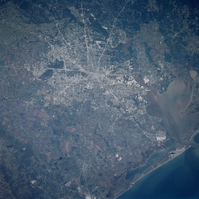
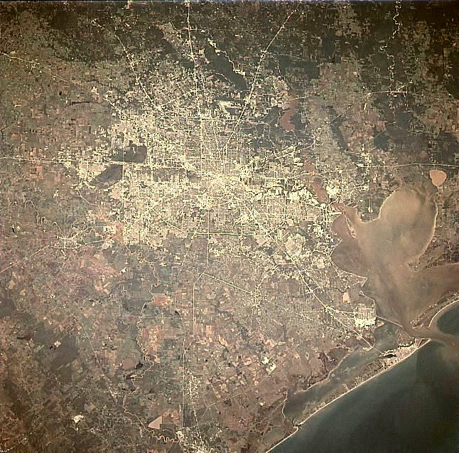
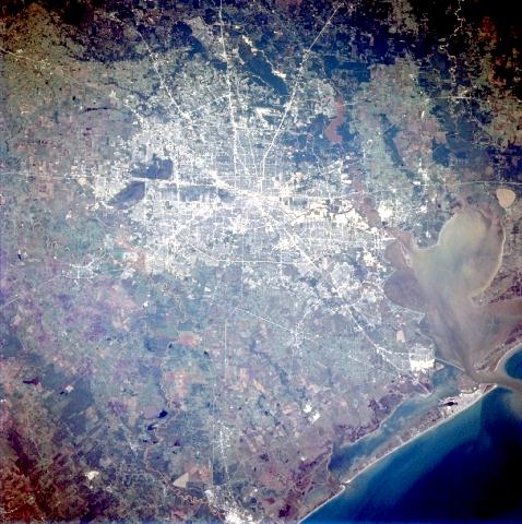
Image Caption: STS095-716-018 Houston Area, Texas, USA November 1998
At least ten major highways converge near downtown Houston (concentrated, bright spot near center of the image), the fourth most populated city in the United States. These highways include Interstate Highways 10 and 45, as well as several other state highways. The gridded, north-south and east-west street pattern within the urban area and the outer beltway (Sam Houston Tollway) can be traced around the outskirts of the growing metropolitan area. The uniform looking dark green areas north and east of the city are mainly undeveloped, heavily wooded, floodplain of the San Jacinto and Trinity Rivers. Houston's international ocean traffic route can be traced through Galveston Bay (by the pattern of darker sediments around the dredged channel) to port facilities in the Houston Ship Channel (dark line with white edges that extends east from near downtown Houston). The opaque, oval-shaped feature on the east edge of the image is Lake Anahuac.
At least ten major highways converge near downtown Houston (concentrated, bright spot near center of the image), the fourth most populated city in the United States. These highways include Interstate Highways 10 and 45, as well as several other state highways. The gridded, north-south and east-west street pattern within the urban area and the outer beltway (Sam Houston Tollway) can be traced around the outskirts of the growing metropolitan area. The uniform looking dark green areas north and east of the city are mainly undeveloped, heavily wooded, floodplain of the San Jacinto and Trinity Rivers. Houston's international ocean traffic route can be traced through Galveston Bay (by the pattern of darker sediments around the dredged channel) to port facilities in the Houston Ship Channel (dark line with white edges that extends east from near downtown Houston). The opaque, oval-shaped feature on the east edge of the image is Lake Anahuac.
