STS095-712-22
| NASA Photo ID | STS095-712-22 |
| Focal Length | 250mm |
| Date taken | 1998.11.02 |
| Time taken | 01:15:52 GMT |

Cloud masks available for this image:
Spacecraft nadir point: 21.5° N, 123.2° E
Photo center point: 23.0° N, 120.5° E
Photo center point by machine learning:
Photo center point: 23.0° N, 120.5° E
Photo center point by machine learning:
Nadir to Photo Center: Northwest
Spacecraft Altitude: 294 nautical miles (544km)
Camera: | Hasselblad |
Focal Length: | 250mm |
Camera Tilt: | 32 degrees |
Format: | 5069: Kodak Elite 100S, E6 Reversal, Replaces Lumiere, Warmer in tone vs. Lumiere |
Film Exposure: | Normal |
| Additional Information | |
| Width | Height | Annotated | Cropped | Purpose | Links |
|---|---|---|---|---|---|
| 4096 pixels | 4096 pixels | No | No | Earth From Space collection | Download Image |
| 640 pixels | 640 pixels | No | No | Earth From Space collection | Download Image |
| 646 pixels | 620 pixels | No | No | Download Image |
Download Packaged File
Download a Google Earth KML for this Image
View photo footprint information
Download a GeoTIFF for this photo
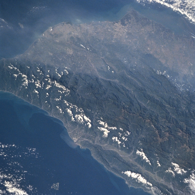
Image Caption: STS095-712-022 Chungyang Mountains, Taiwan November 1998
A section of the rugged, steep sloped and densely forested Chungyang Mountains (dark, north-south aligned feature) can be identified in southern Taiwan. Maximum elevations in this section of the mountain range from slightly over 10000 feet (3048 meters) above sea level in the north (lower right) to less than 6000 feet (1830 meters) in the south (middle left edge). The southerly draining Peinan River Valley along the east coast (light-colored line-bottom center) and the southwesterly draining Chishan River (light-colored line-center of the image) can be traced through the mountainous terrain. The southwest coastal cities of Kaohsiung (upper left) and Tainan (upper center) can be seen through the hazy atmosphere that constantly plagues the highly industrialized and densely populated west coastal plain of Taiwan.
A section of the rugged, steep sloped and densely forested Chungyang Mountains (dark, north-south aligned feature) can be identified in southern Taiwan. Maximum elevations in this section of the mountain range from slightly over 10000 feet (3048 meters) above sea level in the north (lower right) to less than 6000 feet (1830 meters) in the south (middle left edge). The southerly draining Peinan River Valley along the east coast (light-colored line-bottom center) and the southwesterly draining Chishan River (light-colored line-center of the image) can be traced through the mountainous terrain. The southwest coastal cities of Kaohsiung (upper left) and Tainan (upper center) can be seen through the hazy atmosphere that constantly plagues the highly industrialized and densely populated west coastal plain of Taiwan.
