STS095-704-74
| NASA Photo ID | STS095-704-74 |
| Focal Length | 250mm |
| Date taken | 1998.__.__ |
| Time taken | GMT |
Resolutions offered for this image:
4042 x 4042 pixels 640 x 640 pixels 504 x 503 pixels 479 x 478 pixels 506 x 495 pixels
4042 x 4042 pixels 640 x 640 pixels 504 x 503 pixels 479 x 478 pixels 506 x 495 pixels


Cloud masks available for this image:
Spacecraft nadir point:
Photo center point: 28.0° N, 82.5° W
Photo center point by machine learning:
Photo center point: 28.0° N, 82.5° W
Photo center point by machine learning:
Nadir to Photo Center:
Spacecraft Altitude: nautical miles (0km)
Country or Geographic Name: | USA-FLORIDA |
Features: | TAMPA BAY AREA, LAKELAND |
| Features Found Using Machine Learning: | |
Cloud Cover Percentage: | 0 (no clouds present) |
Sun Elevation Angle: | ° |
Sun Azimuth: | ° |
Camera: | Hasselblad |
Focal Length: | 250mm |
Camera Tilt: | Low Oblique |
Format: | 5069: Kodak Elite 100S, E6 Reversal, Replaces Lumiere, Warmer in tone vs. Lumiere |
Film Exposure: | Normal |
| Additional Information | |
| Width | Height | Annotated | Cropped | Purpose | Links |
|---|---|---|---|---|---|
| 4042 pixels | 4042 pixels | No | No | Earth From Space collection | Download Image |
| 640 pixels | 640 pixels | No | No | Earth From Space collection | Download Image |
| 504 pixels | 503 pixels | Earth From Space phase 2 | Download Image | ||
| 479 pixels | 478 pixels | Download Image | |||
| 506 pixels | 495 pixels | No | No | Download Image |
Download Packaged File
Download a Google Earth KML for this Image
View photo footprint information
Download a GeoTIFF for this photo
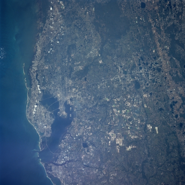
Image Caption: STS095-704-074 Lakeland Area, Florida, USA November 1998
The heavily populated central west coast of the Florida peninsula, centered on Tampa Bay (top), include the urban areas of Tampa, St. Petersburg, and Clearwater in this westerly looking view that extends from the Gulf of Mexico to the karst topography inland. Interstate Highway 4 (light colored, linear feature) runs east and west across the center of the scene from Tampa Bay to the lakes inland at the bottom of the view. The dark, roughly oval features along the eastern (bottom) side of the picture are lakes that have formed in sinkholes that pockmark the underlying limestone rock. The highly reflective, angular surfaces towards the south central part of the picture are open pit phosphate mines. The extensive darker terrain along the north central edge (right) of the image is poorly drained swampland.
The heavily populated central west coast of the Florida peninsula, centered on Tampa Bay (top), include the urban areas of Tampa, St. Petersburg, and Clearwater in this westerly looking view that extends from the Gulf of Mexico to the karst topography inland. Interstate Highway 4 (light colored, linear feature) runs east and west across the center of the scene from Tampa Bay to the lakes inland at the bottom of the view. The dark, roughly oval features along the eastern (bottom) side of the picture are lakes that have formed in sinkholes that pockmark the underlying limestone rock. The highly reflective, angular surfaces towards the south central part of the picture are open pit phosphate mines. The extensive darker terrain along the north central edge (right) of the image is poorly drained swampland.
