STS094-713-12
| NASA Photo ID | STS094-713-12 |
| Focal Length | 250mm |
| Date taken | 1997.07.13 |
| Time taken | 16:37:15 GMT |

Cloud masks available for this image:
Spacecraft nadir point: 4.7° S, 60.6° W
Photo center point: 3.0° S, 60.0° W
Photo center point by machine learning:
Photo center point: 3.0° S, 60.0° W
Photo center point by machine learning:
Nadir to Photo Center: North
Spacecraft Altitude: 161 nautical miles (298km)
Camera: | Hasselblad |
Focal Length: | 250mm |
Camera Tilt: | 34 degrees |
Format: | 5069: Kodak Elite 100S, E6 Reversal, Replaces Lumiere, Warmer in tone vs. Lumiere |
Film Exposure: | Normal |
| Additional Information | |
| Width | Height | Annotated | Cropped | Purpose | Links |
|---|---|---|---|---|---|
| 4054 pixels | 4091 pixels | No | No | Earth From Space collection | Download Image |
| 634 pixels | 640 pixels | No | No | Earth From Space collection | Download Image |
Download Packaged File
Download a Google Earth KML for this Image
View photo footprint information
Download a GeoTIFF for this photo
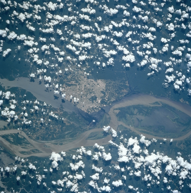
Image Caption: STS094-713-012 Manaus, Brazil July 1997
Located 1000 miles (1610 km) upstream from the mouth of the Amazon River is the growing city of Manaus. Manaus sits on the north bank of the Rio Negro 12 miles (18 km) from where it joins the Amazon River. Manaus is the chief commercial and cultural center of the middle and upper Amazon Basin and is an important river port. During the 1800's and early 1900's, it was the important city during the rubber boom of that era. With the rubber boom collapse, the city sank into decay, obscurity, and poverty. When the city was declared a free trade zone in the middle 1960's, Manaus became revitalized with new industry, rapid growth, and escalating prosperity. Manaus's growth and prosperity were further enhanced with the discovery of oil nearby. The city now has a population of over one million people. Manaus continues to grow and expanded and is fast becoming one of Brazil's most important commercial, industrial, and banking cities. The Amazon River is visible entering the scene from midway between the bottom left and left center (west) exiting the scene just below the center right (east). The Rio Negro enters the scene at the left center (northwest) of the image.
Located 1000 miles (1610 km) upstream from the mouth of the Amazon River is the growing city of Manaus. Manaus sits on the north bank of the Rio Negro 12 miles (18 km) from where it joins the Amazon River. Manaus is the chief commercial and cultural center of the middle and upper Amazon Basin and is an important river port. During the 1800's and early 1900's, it was the important city during the rubber boom of that era. With the rubber boom collapse, the city sank into decay, obscurity, and poverty. When the city was declared a free trade zone in the middle 1960's, Manaus became revitalized with new industry, rapid growth, and escalating prosperity. Manaus's growth and prosperity were further enhanced with the discovery of oil nearby. The city now has a population of over one million people. Manaus continues to grow and expanded and is fast becoming one of Brazil's most important commercial, industrial, and banking cities. The Amazon River is visible entering the scene from midway between the bottom left and left center (west) exiting the scene just below the center right (east). The Rio Negro enters the scene at the left center (northwest) of the image.
