STS091-715-5
| NASA Photo ID | STS091-715-5 |
| Focal Length | 250mm |
| Date taken | 1998.06.11 |
| Time taken | 09:47:33 GMT |

Cloud masks available for this image:
Spacecraft nadir point: 41.3° N, 73.2° E
Photo center point: 42.5° N, 77.5° E
Photo center point by machine learning:
Photo center point: 42.5° N, 77.5° E
Photo center point by machine learning:
Nadir to Photo Center: East
Spacecraft Altitude: 196 nautical miles (363km)
Country or Geographic Name: | KYRGYZSTAN |
Features: | LAKE ISSYKKUL |
| Features Found Using Machine Learning: | |
Cloud Cover Percentage: | 10 (1-10)% |
Sun Elevation Angle: | 52° |
Sun Azimuth: | 254° |
Camera: | Hasselblad |
Focal Length: | 250mm |
Camera Tilt: | 54 degrees |
Format: | 5069: Kodak Elite 100S, E6 Reversal, Replaces Lumiere, Warmer in tone vs. Lumiere |
Film Exposure: | Normal |
| Additional Information | |
| Width | Height | Annotated | Cropped | Purpose | Links |
|---|---|---|---|---|---|
| 4096 pixels | 4096 pixels | No | No | Earth From Space collection | Download Image |
| 640 pixels | 640 pixels | No | No | Earth From Space collection | Download Image |
Download Packaged File
Download a Google Earth KML for this Image
View photo footprint information
Download a GeoTIFF for this photo
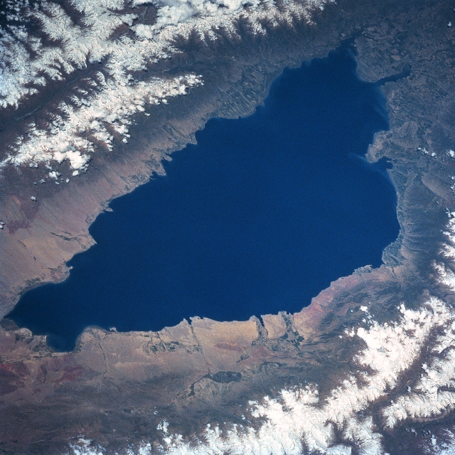
Image Caption: STS091-715-005 Issyk-Kul, Kyrgystan June 1998
Located in northeast Kyrgyzstan, Issyk-Kul is one of the deepest mountain lakes in the world with a maximum depth of 2303 feet (702 meters). Named for the "warm water" that the lake contains, this slightly brackish lake never freezes. Issyk-Kul could be called "Mile High Lake" since the surface of the lake is 5280 feet (1609 meters) above sea level. The lake is 115 miles (185 km) in length and 38 miles (61 km) at its widest point. The basin that the lake sits in is the result of a block of the earth's crust that subsided between two faults, known as a graben. Eroded debris (lighter-colored landscape) from the elevated mountain slopes is more recognizable around the western end of the lake and the darker terrain around the eastern end of the lake shows cultivated field patterns (mainly wheat fields). The north and south shorelines around the lake were once part of the Great Silk Road that connected China with the Middle East and parts of Russia. Although the region is semi-arid, snowmelt (runoff) from the surrounding mountains (seen here as snow capped mountains) provides sufficient fresh water to allow dry land farming on the flatter plains within the valleys. Mountain ranges north (Kiungey-Ala-Too) and south (Terskey-Ala-Too) of the lake with peaks that range between 13000 feet (3962 meters) to 18000 feet (5486 meters) are part of the regional Tien Shan (mountains).
Located in northeast Kyrgyzstan, Issyk-Kul is one of the deepest mountain lakes in the world with a maximum depth of 2303 feet (702 meters). Named for the "warm water" that the lake contains, this slightly brackish lake never freezes. Issyk-Kul could be called "Mile High Lake" since the surface of the lake is 5280 feet (1609 meters) above sea level. The lake is 115 miles (185 km) in length and 38 miles (61 km) at its widest point. The basin that the lake sits in is the result of a block of the earth's crust that subsided between two faults, known as a graben. Eroded debris (lighter-colored landscape) from the elevated mountain slopes is more recognizable around the western end of the lake and the darker terrain around the eastern end of the lake shows cultivated field patterns (mainly wheat fields). The north and south shorelines around the lake were once part of the Great Silk Road that connected China with the Middle East and parts of Russia. Although the region is semi-arid, snowmelt (runoff) from the surrounding mountains (seen here as snow capped mountains) provides sufficient fresh water to allow dry land farming on the flatter plains within the valleys. Mountain ranges north (Kiungey-Ala-Too) and south (Terskey-Ala-Too) of the lake with peaks that range between 13000 feet (3962 meters) to 18000 feet (5486 meters) are part of the regional Tien Shan (mountains).
