STS091-714-56

| NASA Photo ID | STS091-714-56 |
| Focal Length | 250mm |
| Date taken | 1998.06.__ |
| Time taken | GMT |
Cloud masks available for this image:
Spacecraft nadir point:
Photo center point: 41.0° N, 58.0° E
Photo center point by machine learning:
Photo center point: 41.0° N, 58.0° E
Photo center point by machine learning:
Nadir to Photo Center:
Spacecraft Altitude: nautical miles (0km)
Country or Geographic Name: | TURKMENISTAN |
Features: | SARYKAMYSHKOYE LAKE |
| Features Found Using Machine Learning: | |
Cloud Cover Percentage: | 5 (1-10)% |
Sun Elevation Angle: | ° |
Sun Azimuth: | ° |
Camera: | Hasselblad |
Focal Length: | 250mm |
Camera Tilt: | Low Oblique |
Format: | 5069: Kodak Elite 100S, E6 Reversal, Replaces Lumiere, Warmer in tone vs. Lumiere |
Film Exposure: | Normal |
| Additional Information | |
| Width | Height | Annotated | Cropped | Purpose | Links |
|---|---|---|---|---|---|
| 4096 pixels | 4096 pixels | No | No | Earth From Space collection | Download Image |
| 640 pixels | 640 pixels | No | No | Earth From Space collection | Download Image |
Download Packaged File
Download a Google Earth KML for this Image
View photo footprint information
Download a GeoTIFF for this photo
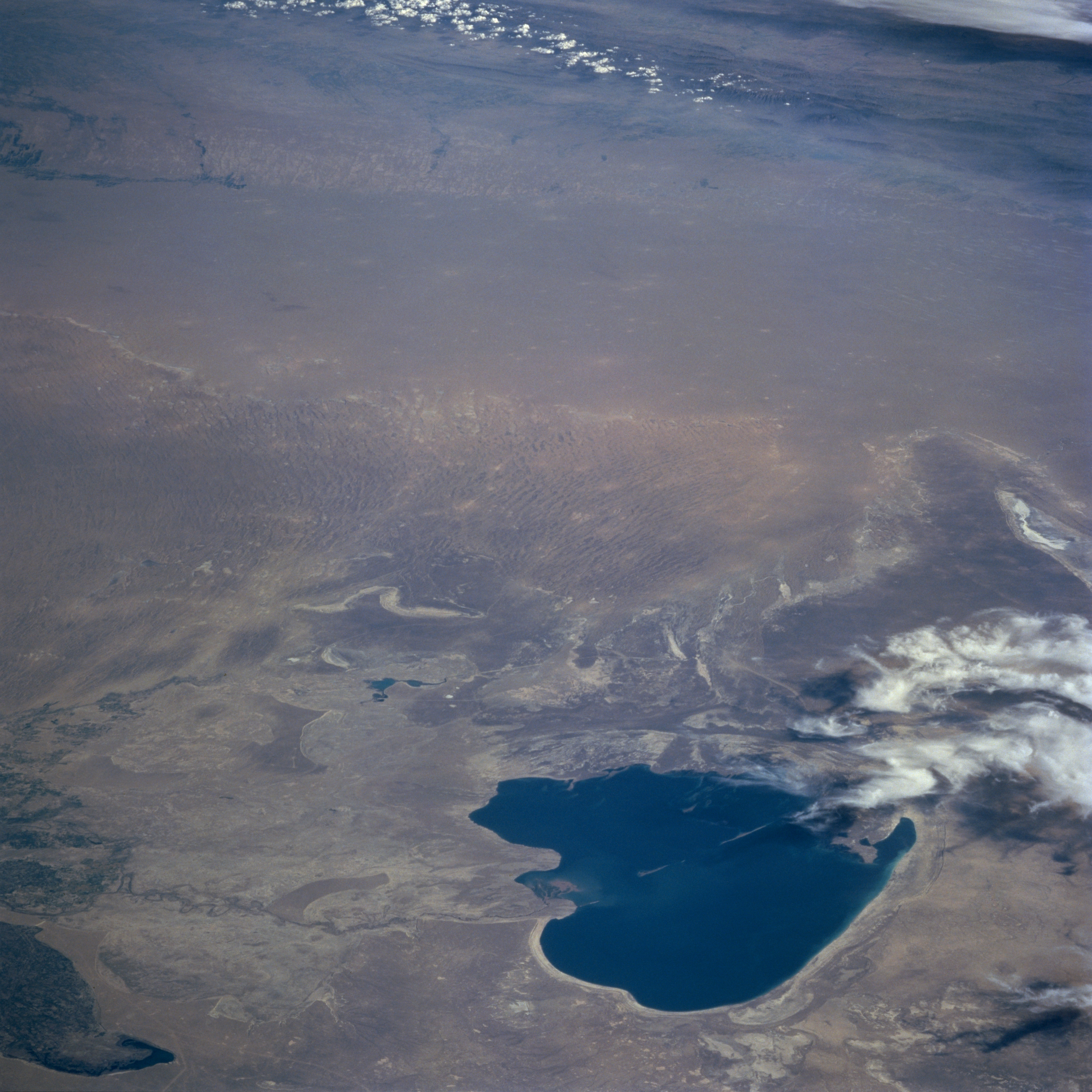
Image Caption: STS091-714-056 Lake Sarygamysh, Turkmenistan June 1998
Looking south across Lake Sarygamysh (dark feature, bottom center), a broad expanse of desert landscape is visible. Lake Sarygamysh, situated in north central Turkmenistan, is geographically located midway between the Caspian Sea and the Aral Sea. This desert, known as the Garagum Desert, extends from the Ust-Urt Plateau (north of the lake) to the Kopet-Dag Mountains (upper right corner) in the south of Turkmenistan and from the Amu Darya River in the east and almost reaching the Caspian Sea to the west of the desert. The desert is characterized by relatively flat terrain with large areas of sand dunes and sand ridges (visible near center of the picture). The darker feature south of the lake (right middle) is a grassy elevated plain. The white areas immediately southwest of the lake (lower right corner) are clouds. Although the lake is filled with water at the time this photograph was acquired, some maps indicate that the lake is, at least partially, a dry lakebed from time to time. Approximately the northwest quarter of the lake belongs to the country of Uzbekistan.
Looking south across Lake Sarygamysh (dark feature, bottom center), a broad expanse of desert landscape is visible. Lake Sarygamysh, situated in north central Turkmenistan, is geographically located midway between the Caspian Sea and the Aral Sea. This desert, known as the Garagum Desert, extends from the Ust-Urt Plateau (north of the lake) to the Kopet-Dag Mountains (upper right corner) in the south of Turkmenistan and from the Amu Darya River in the east and almost reaching the Caspian Sea to the west of the desert. The desert is characterized by relatively flat terrain with large areas of sand dunes and sand ridges (visible near center of the picture). The darker feature south of the lake (right middle) is a grassy elevated plain. The white areas immediately southwest of the lake (lower right corner) are clouds. Although the lake is filled with water at the time this photograph was acquired, some maps indicate that the lake is, at least partially, a dry lakebed from time to time. Approximately the northwest quarter of the lake belongs to the country of Uzbekistan.
