STS090-758-22
| NASA Photo ID | STS090-758-22 |
| Focal Length | 250mm |
| Date taken | 1998.04.20 |
| Time taken | 19:45:47 GMT |
Resolutions offered for this image:
1000 x 1000 pixels 4061 x 4061 pixels 639 x 639 pixels 2513 x 2514 pixels 2513 x 2514 pixels 473 x 461 pixels 478 x 479 pixels
1000 x 1000 pixels 4061 x 4061 pixels 639 x 639 pixels 2513 x 2514 pixels 2513 x 2514 pixels 473 x 461 pixels 478 x 479 pixels


Cloud masks available for this image:
Spacecraft nadir point: 32.6° N, 114.7° W
Photo center point: 33.0° N, 115.5° W
Photo center point by machine learning:
Photo center point: 33.0° N, 115.5° W
Photo center point by machine learning:
Nadir to Photo Center: Northwest
Spacecraft Altitude: 136 nautical miles (252km)
Camera: | Hasselblad |
Focal Length: | 250mm |
Camera Tilt: | 22 degrees |
Format: | 5069: Kodak Elite 100S, E6 Reversal, Replaces Lumiere, Warmer in tone vs. Lumiere |
Film Exposure: | Normal |
| Additional Information | |
| Width | Height | Annotated | Cropped | Purpose | Links |
|---|---|---|---|---|---|
| 1000 pixels | 1000 pixels | No | No | Cities collection | Download Image |
| 4061 pixels | 4061 pixels | No | No | Earth From Space collection | Download Image |
| 639 pixels | 639 pixels | No | No | Earth From Space collection | Download Image |
| 2513 pixels | 2514 pixels | Download Image | |||
| 2513 pixels | 2514 pixels | Download Image | |||
| 473 pixels | 461 pixels | No | No | Download Image | |
| 478 pixels | 479 pixels | Download Image |
Download Packaged File
Download a Google Earth KML for this Image
View photo footprint information
Download a GeoTIFF for this photo
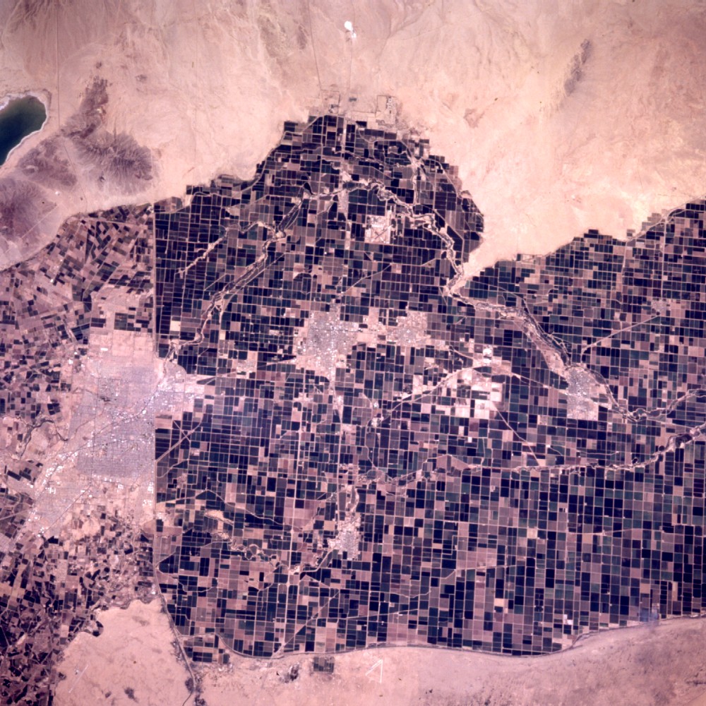
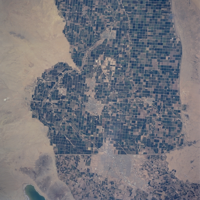
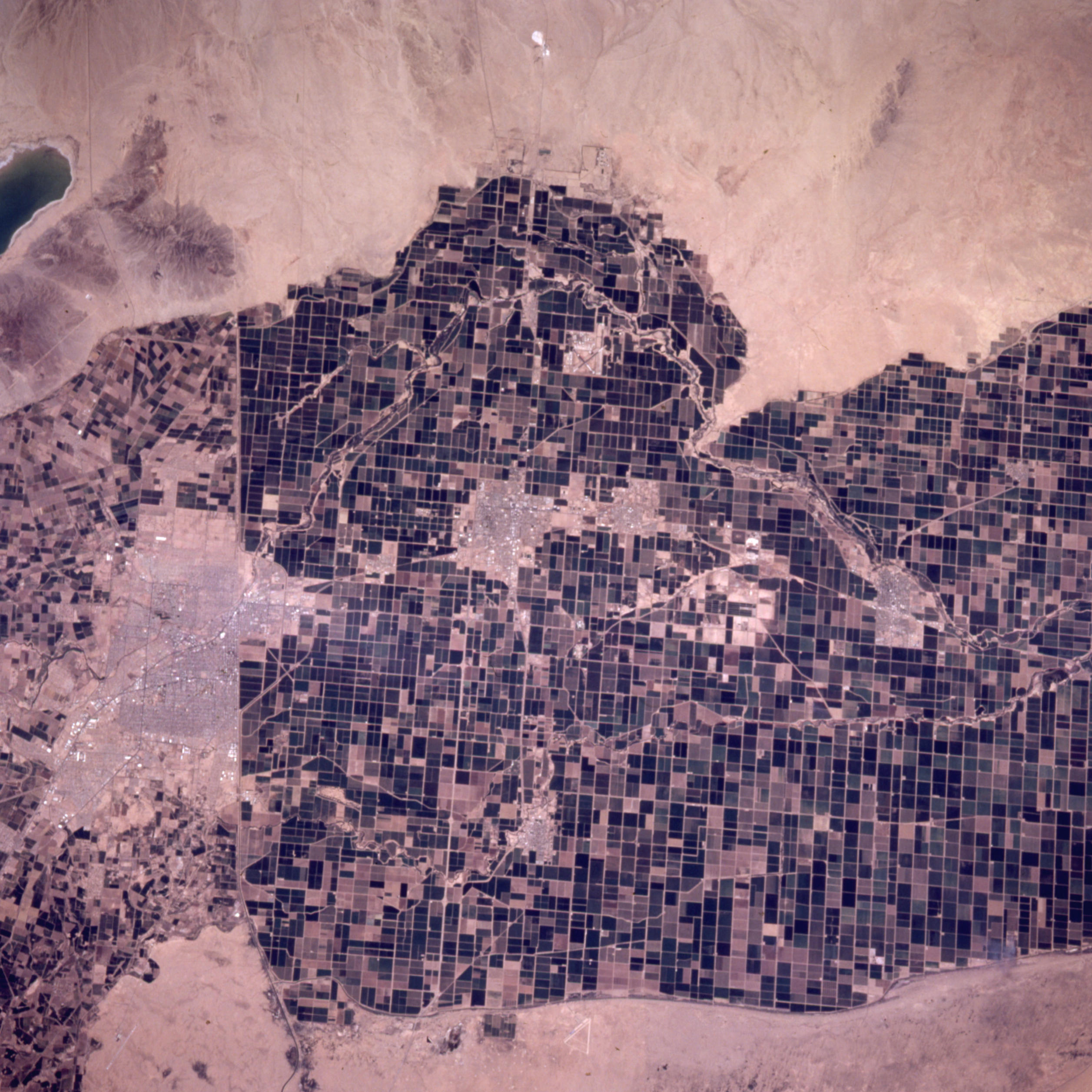
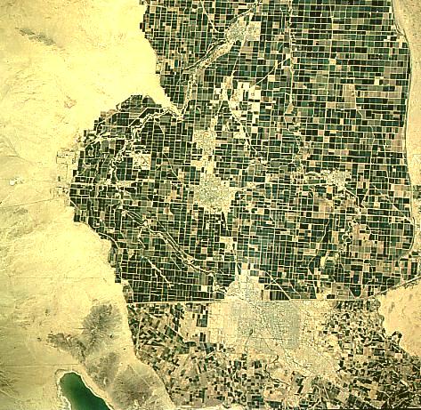
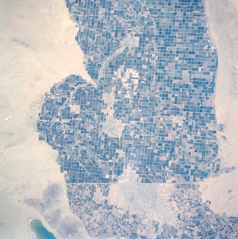
Image Caption: STS090-758-022 Imperial Valley, California, USA April 1997
The border between the United States and Mexico consists of intensively cultivated field patterns. This area is the Imperial Valley of south central California. Although the extensive array of large productive fields is located in a desert environment, the image indicates where effective irrigation (from water provided by the Colorado River) has turned this normally arid landscape into a highly productive agricultural region. The only disruptions to the cultivated landscape are a few cities on the U. S. side of the border (El Centro, Calexico, Brawley, and Holtville) and the much large city of Mexicali on the Mexican side of the border. Notice that there is an obvious difference in land management and ownership on the two sides of the border. Several canals, mainly the Westside Main Canal (white, winding, feature), are used for irrigation purposes and can be traced across the plain of the Imperial Valley. The greenish looking feature in the southwest corner of the image is the northern tip of Laguna Salada.
The border between the United States and Mexico consists of intensively cultivated field patterns. This area is the Imperial Valley of south central California. Although the extensive array of large productive fields is located in a desert environment, the image indicates where effective irrigation (from water provided by the Colorado River) has turned this normally arid landscape into a highly productive agricultural region. The only disruptions to the cultivated landscape are a few cities on the U. S. side of the border (El Centro, Calexico, Brawley, and Holtville) and the much large city of Mexicali on the Mexican side of the border. Notice that there is an obvious difference in land management and ownership on the two sides of the border. Several canals, mainly the Westside Main Canal (white, winding, feature), are used for irrigation purposes and can be traced across the plain of the Imperial Valley. The greenish looking feature in the southwest corner of the image is the northern tip of Laguna Salada.
