STS090-754-79
| NASA Photo ID | STS090-754-79 |
| Focal Length | 40mm |
| Date taken | 1998.05.02 |
| Time taken | 17:35:59 GMT |
Resolutions offered for this image:
4043 x 4055 pixels 638 x 639 pixels 503 x 511 pixels 479 x 479 pixels
4043 x 4055 pixels 638 x 639 pixels 503 x 511 pixels 479 x 479 pixels

Cloud masks available for this image:
Spacecraft nadir point: 26.1° N, 82.8° W
Photo center point: 27.5° N, 82.5° W
Photo center point by machine learning:
Photo center point: 27.5° N, 82.5° W
Photo center point by machine learning:
Nadir to Photo Center: North
Spacecraft Altitude: 131 nautical miles (243km)
Country or Geographic Name: | USA-FLORIDA |
Features: | SOUTH FLORIDA, SUNGLINT |
| Features Found Using Machine Learning: | |
Cloud Cover Percentage: | 5 (1-10)% |
Sun Elevation Angle: | 79° |
Sun Azimuth: | 190° |
Camera: | Hasselblad |
Focal Length: | 40mm |
Camera Tilt: | 33 degrees |
Format: | 5069: Kodak Elite 100S, E6 Reversal, Replaces Lumiere, Warmer in tone vs. Lumiere |
Film Exposure: | Normal |
| Additional Information | |
| Width | Height | Annotated | Cropped | Purpose | Links |
|---|---|---|---|---|---|
| 4043 pixels | 4055 pixels | No | No | Earth From Space collection | Download Image |
| 638 pixels | 639 pixels | No | No | Earth From Space collection | Download Image |
| 503 pixels | 511 pixels | No | No | Download Image | |
| 479 pixels | 479 pixels | Download Image |
Download Packaged File
Download a Google Earth KML for this Image
View photo footprint information
Download a GeoTIFF for this photo
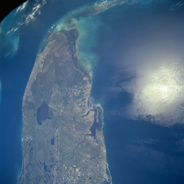
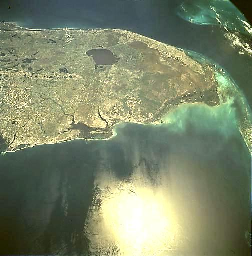
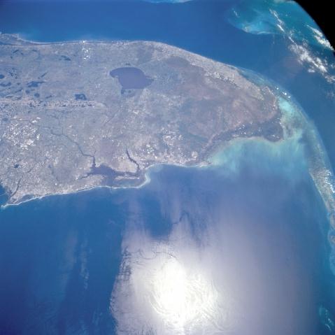
Image Caption: STS090-754-079 Southern Florida, Florida, USA April 1998
The southern half of the Florida peninsula is visible from Cape Canaveral along the east coast to the Florida Keys. The synoptic nature of this view provides a unique opportunity to identify and locate the major geographic features in south Florida. These features include the densely populated southeast coast of Florida, including the greater Miami metropolitan area; the largely uninhabited Everglades at the south end of the Florida peninsula; the Fort Myers area (immediately south of the large bay on the west coast of the peninsula) and Lake Okeechobee (large dark feature northwest of the Miami area). The karst topography of central Florida is identified by numerous lakes (sink holes). These lakes are created by water reacting with the limestone rocks that underlay the Florida peninsula. The deep, blue water of the Gulf Stream is visible between Miami and Bimini Island in the Bahamas. The very bright spot off of the west coast of Florida in the Gulf of Mexico is the sun's reflection off of the water's surface (called sunglint or sun glitter).
The southern half of the Florida peninsula is visible from Cape Canaveral along the east coast to the Florida Keys. The synoptic nature of this view provides a unique opportunity to identify and locate the major geographic features in south Florida. These features include the densely populated southeast coast of Florida, including the greater Miami metropolitan area; the largely uninhabited Everglades at the south end of the Florida peninsula; the Fort Myers area (immediately south of the large bay on the west coast of the peninsula) and Lake Okeechobee (large dark feature northwest of the Miami area). The karst topography of central Florida is identified by numerous lakes (sink holes). These lakes are created by water reacting with the limestone rocks that underlay the Florida peninsula. The deep, blue water of the Gulf Stream is visible between Miami and Bimini Island in the Bahamas. The very bright spot off of the west coast of Florida in the Gulf of Mexico is the sun's reflection off of the water's surface (called sunglint or sun glitter).
