STS090-752-36
| NASA Photo ID | STS090-752-36 |
| Focal Length | 250mm |
| Date taken | 1998.05.02 |
| Time taken | 14:22:07 GMT |
Resolutions offered for this image:
4013 x 4085 pixels 628 x 640 pixels 512 x 522 pixels 479 x 479 pixels
4013 x 4085 pixels 628 x 640 pixels 512 x 522 pixels 479 x 479 pixels


Cloud masks available for this image:
Spacecraft nadir point: 38.0° N, 102.7° W
Photo center point: 38.0° N, 105.5° W
Photo center point by machine learning:
Photo center point: 38.0° N, 105.5° W
Photo center point by machine learning:
Nadir to Photo Center: West
Spacecraft Altitude: 134 nautical miles (248km)
Country or Geographic Name: | USA-COLORADO |
Features: | SAND DUNES, SAN LUIS V. |
| Features Found Using Machine Learning: | |
Cloud Cover Percentage: | 0 (no clouds present) |
Sun Elevation Angle: | 28° |
Sun Azimuth: | 92° |
Camera: | Hasselblad |
Focal Length: | 250mm |
Camera Tilt: | 51 degrees |
Format: | 5069: Kodak Elite 100S, E6 Reversal, Replaces Lumiere, Warmer in tone vs. Lumiere |
Film Exposure: | Normal |
| Additional Information | |
| Width | Height | Annotated | Cropped | Purpose | Links |
|---|---|---|---|---|---|
| 4013 pixels | 4085 pixels | No | No | Earth From Space collection | Download Image |
| 628 pixels | 640 pixels | No | No | Earth From Space collection | Download Image |
| 512 pixels | 522 pixels | No | No | Download Image | |
| 479 pixels | 479 pixels | Download Image |
Download Packaged File
Download a Google Earth KML for this Image
View photo footprint information
Download a GeoTIFF for this photo
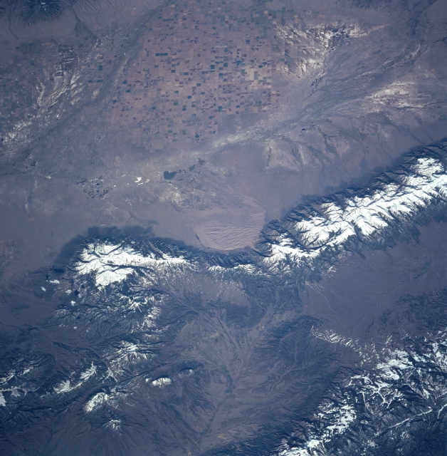
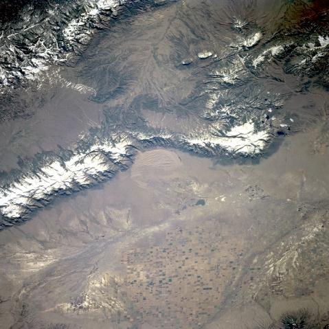
Image Caption: STS090-752-036 San Luis Valley, Colorado, USA April 1998
The San Luis Valley in south central Colorado has an arid climate and is intensively cultivated for commercial agriculture. Even in this small-scale image, the widespread use of center pivot irrigation techniques is apparent. Notice several dendritic drainage patterns within the valley. These drainage patterns include the San Luis and Saguache Rivers in the northern section of the valley and the Rio Grand near the southwestern side. These patterns are enhanced by the highly mineralized surfaces (whitish looking saline soils) where agriculture is no longer possible due to the salinity of the soils. Great Sand Dunes National Monument is visible in the center of the picture. The snow-covered Sangre de Cristo Mountains border the east side of the San Luis Valley.
The San Luis Valley in south central Colorado has an arid climate and is intensively cultivated for commercial agriculture. Even in this small-scale image, the widespread use of center pivot irrigation techniques is apparent. Notice several dendritic drainage patterns within the valley. These drainage patterns include the San Luis and Saguache Rivers in the northern section of the valley and the Rio Grand near the southwestern side. These patterns are enhanced by the highly mineralized surfaces (whitish looking saline soils) where agriculture is no longer possible due to the salinity of the soils. Great Sand Dunes National Monument is visible in the center of the picture. The snow-covered Sangre de Cristo Mountains border the east side of the San Luis Valley.
