STS090-751-54
| NASA Photo ID | STS090-751-54 |
| Focal Length | 250mm |
| Date taken | 1998.05.02 |
| Time taken | 17:36:14 GMT |
Resolutions offered for this image:
4061 x 4091 pixels 635 x 640 pixels 5122 x 5074 pixels 5165 x 5083 pixels 509 x 512 pixels 479 x 479 pixels
4061 x 4091 pixels 635 x 640 pixels 5122 x 5074 pixels 5165 x 5083 pixels 509 x 512 pixels 479 x 479 pixels


Cloud masks available for this image:
Spacecraft nadir point: 25.8° N, 82.2° W
Photo center point: 25.5° N, 80.5° W
Photo center point by machine learning:
Photo center point: 25.5° N, 80.5° W
Photo center point by machine learning:
Nadir to Photo Center: East
Spacecraft Altitude: 131 nautical miles (243km)
Country or Geographic Name: | USA-FLORIDA |
Features: | KEY LARGO, EVERGLADES |
| Features Found Using Machine Learning: | |
Cloud Cover Percentage: | 0 (no clouds present) |
Sun Elevation Angle: | 80° |
Sun Azimuth: | 194° |
Camera: | Hasselblad |
Focal Length: | 250mm |
Camera Tilt: | 38 degrees |
Format: | 5069: Kodak Elite 100S, E6 Reversal, Replaces Lumiere, Warmer in tone vs. Lumiere |
Film Exposure: | Normal |
| Additional Information | |
| Width | Height | Annotated | Cropped | Purpose | Links |
|---|---|---|---|---|---|
| 4061 pixels | 4091 pixels | No | No | Earth From Space collection | Download Image |
| 635 pixels | 640 pixels | No | No | Earth From Space collection | Download Image |
| 5122 pixels | 5074 pixels | Reef RS | Download Image | ||
| 5165 pixels | 5083 pixels | Download Image | |||
| 509 pixels | 512 pixels | No | No | Download Image | |
| 479 pixels | 479 pixels | Download Image |
Download Packaged File
Download a Google Earth KML for this Image
View photo footprint information
Download a GeoTIFF for this photo
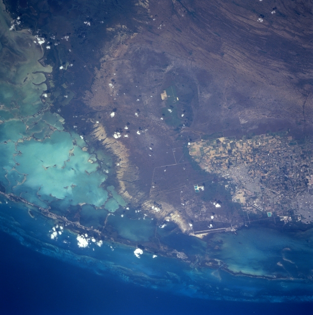
Image Caption: STS090-751-54 South Florida, Florida, USA April 1998
Most of the southern tip of the mainland of Florida is visible in this easterly view that includes a variety of recognizable features. The highly reflective, light blue-green area along the southern edge of the picture is part of Florida Bay, a very shallow body of water where water depths rarely exceed 10 feet (3 meters). The darker landscape in the southwest corner of the picture is part of an extensive mangrove forest that borders the southern coastline of Florida. The alternating bands of light and dark (northwest corner) are sawgrass wetlands of Everglades National Park. In this section of the Everglades, water flow changes from the more characteristic north-south flow to a more southwesterly flow as it nears the coast. The city of Homestead (light-colored area north-center) is surrounded by extensive agriculture. A variety of vegetables are produced in this region of south Florida. Runways (light-colored lines) of Homestead Air Force Base are visible along the east edge of Homestead. The two even longer, parallel lines southeast of Homestead and adjacent to the southwest side of Biscayne Bay are cooling canals for the Turkey Point Power Generating Plant. The northern extent of the Florida Keys, a 225-mile (362-kilometer) chain of small islands that extends southwest from the Florida mainland, is also visible. Different shades of blue water here are roughly correlated with water depths--lighter shades of blue generally indicate water depths in the tens of feet, while darker blues can indicate depths in the hundreds of feet.
Most of the southern tip of the mainland of Florida is visible in this easterly view that includes a variety of recognizable features. The highly reflective, light blue-green area along the southern edge of the picture is part of Florida Bay, a very shallow body of water where water depths rarely exceed 10 feet (3 meters). The darker landscape in the southwest corner of the picture is part of an extensive mangrove forest that borders the southern coastline of Florida. The alternating bands of light and dark (northwest corner) are sawgrass wetlands of Everglades National Park. In this section of the Everglades, water flow changes from the more characteristic north-south flow to a more southwesterly flow as it nears the coast. The city of Homestead (light-colored area north-center) is surrounded by extensive agriculture. A variety of vegetables are produced in this region of south Florida. Runways (light-colored lines) of Homestead Air Force Base are visible along the east edge of Homestead. The two even longer, parallel lines southeast of Homestead and adjacent to the southwest side of Biscayne Bay are cooling canals for the Turkey Point Power Generating Plant. The northern extent of the Florida Keys, a 225-mile (362-kilometer) chain of small islands that extends southwest from the Florida mainland, is also visible. Different shades of blue water here are roughly correlated with water depths--lighter shades of blue generally indicate water depths in the tens of feet, while darker blues can indicate depths in the hundreds of feet.
