STS090-740-63

| NASA Photo ID | STS090-740-63 |
| Focal Length | 250mm |
| Date taken | 1998.04.26 |
| Time taken | 21:03:25 GMT |
Resolutions offered for this image:
4079 x 4085 pixels 639 x 640 pixels 509 x 479 pixels 479 x 479 pixels
4079 x 4085 pixels 639 x 640 pixels 509 x 479 pixels 479 x 479 pixels

Cloud masks available for this image:
Spacecraft nadir point: 35.4° N, 113.1° W
Photo center point: 36.0° N, 115.0° W
Photo center point by machine learning:
Photo center point: 36.0° N, 115.0° W
Photo center point by machine learning:
Nadir to Photo Center: West
Spacecraft Altitude: 133 nautical miles (246km)
Country or Geographic Name: | USA-NEVADA |
Features: | LAS VEGAS |
| Features Found Using Machine Learning: | |
Cloud Cover Percentage: | 0 (no clouds present) |
Sun Elevation Angle: | 60° |
Sun Azimuth: | 230° |
Camera: | Hasselblad |
Focal Length: | 250mm |
Camera Tilt: | 42 degrees |
Format: | 5069: Kodak Elite 100S, E6 Reversal, Replaces Lumiere, Warmer in tone vs. Lumiere |
Film Exposure: | Normal |
| Additional Information | |
| Width | Height | Annotated | Cropped | Purpose | Links |
|---|---|---|---|---|---|
| 4079 pixels | 4085 pixels | No | No | Earth From Space collection | Download Image |
| 639 pixels | 640 pixels | No | No | Earth From Space collection | Download Image |
| 509 pixels | 479 pixels | No | No | Download Image | |
| 479 pixels | 479 pixels | Download Image |
Download Packaged File
Download a Google Earth KML for this Image
View photo footprint information
Download a GeoTIFF for this photo
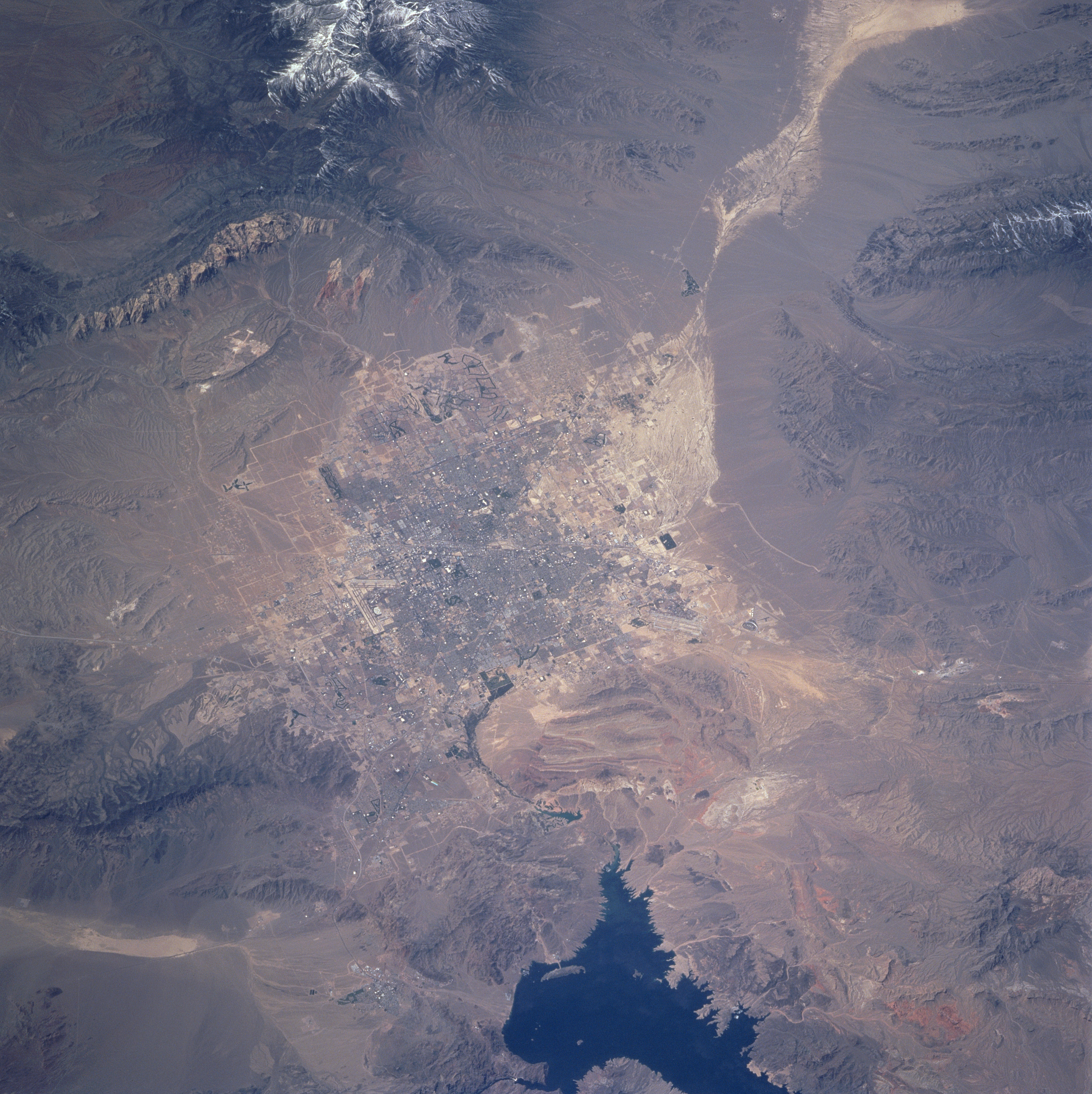
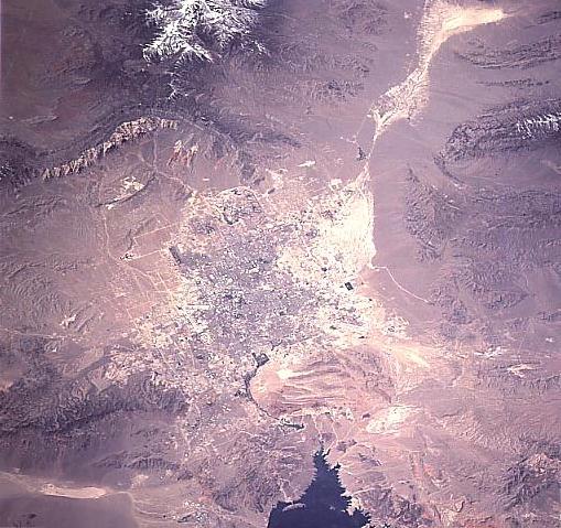
Image Caption: STS090-740-063 Las Vegas Valley, Nevada, USA April 1998
This photograph shows one of the United States' fastest growing metropolitan areas --Las Vegas. The city lies in a valley surrounded by the Spring Mountains (to the west), the Sheep Range (to the north), Muddy Mountains (to the northeast), and the McCullough Range (to the south). The snow-capped Spring Mountains include Mt. Charleston (11,918 feet--3633 meters above sea level), a favorite tourist spot located forty miles (64 kilometers) northwest of Las Vegas. The lighter colored, connected diamond shapes northwest of the urban area are a series of dry washes and salt pans with virtually no vegetation. The dark feature along the eastern edge (bottom middle) of the image is the western end of Lake Mead. Detailed infrastructure of the city is not visible at this scale, except the white V-shaped runways of McCarran International Airport (on the south edge of the built-up area) and the overall gridded street pattern.
This photograph shows one of the United States' fastest growing metropolitan areas --Las Vegas. The city lies in a valley surrounded by the Spring Mountains (to the west), the Sheep Range (to the north), Muddy Mountains (to the northeast), and the McCullough Range (to the south). The snow-capped Spring Mountains include Mt. Charleston (11,918 feet--3633 meters above sea level), a favorite tourist spot located forty miles (64 kilometers) northwest of Las Vegas. The lighter colored, connected diamond shapes northwest of the urban area are a series of dry washes and salt pans with virtually no vegetation. The dark feature along the eastern edge (bottom middle) of the image is the western end of Lake Mead. Detailed infrastructure of the city is not visible at this scale, except the white V-shaped runways of McCarran International Airport (on the south edge of the built-up area) and the overall gridded street pattern.
