STS090-732-76

| NASA Photo ID | STS090-732-76 |
| Focal Length | 250mm |
| Date taken | 1998.04.30 |
| Time taken | 20:51:56 GMT |
Cloud masks available for this image:
Spacecraft nadir point: 15.8° N, 100.7° W
Photo center point: 17.0° N, 100.0° W
Photo center point by machine learning:
Photo center point: 17.0° N, 100.0° W
Photo center point by machine learning:
Nadir to Photo Center: Northeast
Spacecraft Altitude: 134 nautical miles (248km)
Country or Geographic Name: | MEXICO |
Features: | ACAPULCO |
| Features Found Using Machine Learning: | |
Cloud Cover Percentage: | 0 (no clouds present) |
Sun Elevation Angle: | 58° |
Sun Azimuth: | 273° |
Camera: | Hasselblad |
Focal Length: | 250mm |
Camera Tilt: | 32 degrees |
Format: | 5069: Kodak Elite 100S, E6 Reversal, Replaces Lumiere, Warmer in tone vs. Lumiere |
Film Exposure: | Normal |
| Additional Information | |
| Width | Height | Annotated | Cropped | Purpose | Links |
|---|---|---|---|---|---|
| 4060 pixels | 4060 pixels | No | No | Earth From Space collection | Download Image |
| 639 pixels | 639 pixels | No | No | Earth From Space collection | Download Image |
| 510 pixels | 505 pixels | No | No | Download Image |
Download Packaged File
Download a Google Earth KML for this Image
View photo footprint information
Download a GeoTIFF for this photo
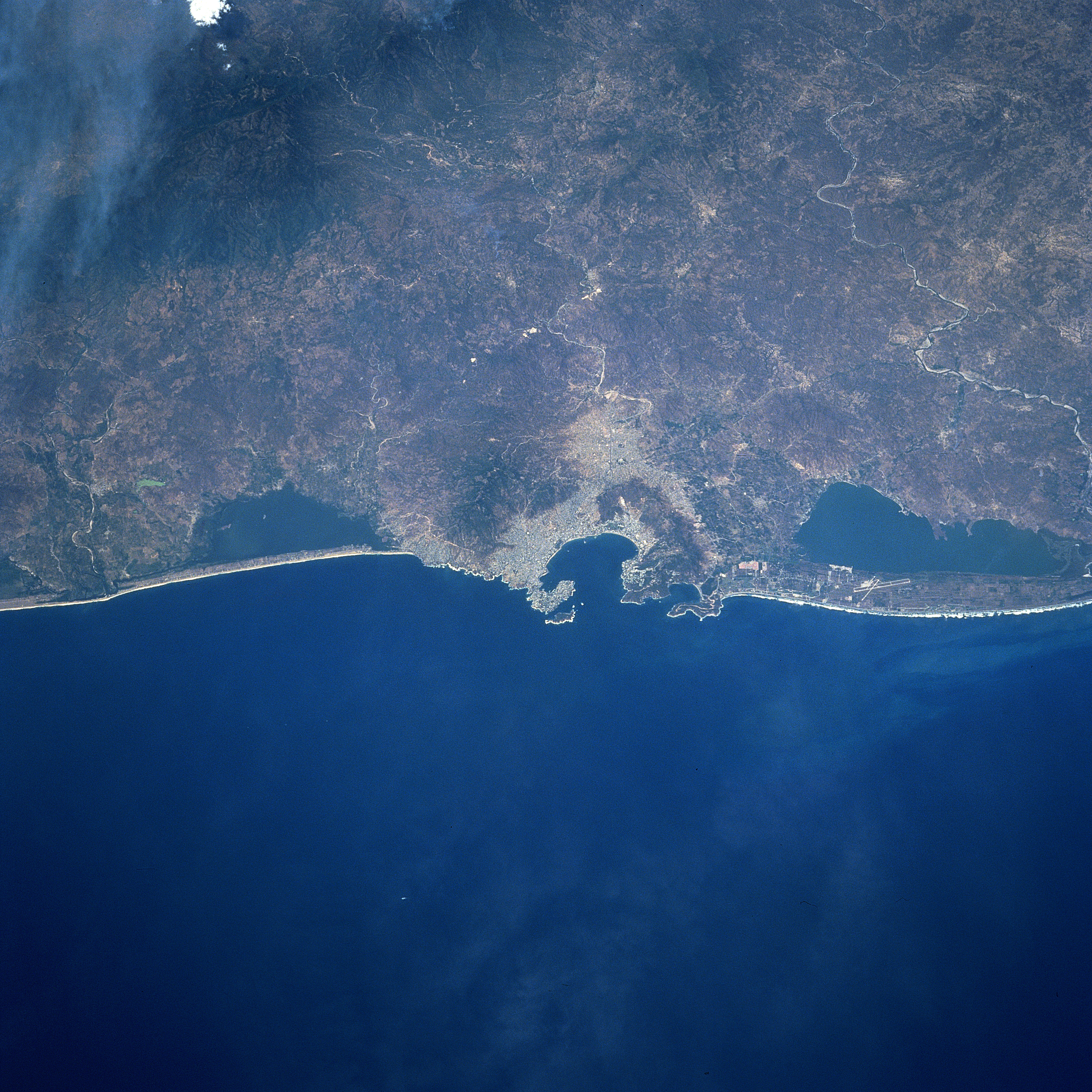
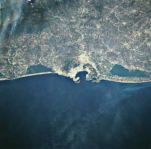
Image Caption: STS090-732-076 Acapulco, Mexico April 1998
Near the center of the image, the international resort city of Acapulco and Acapulco Bay can be seen in this north-northeast-looking view. With the city's fine natural harbor, considered one of the best in Central America, Acapulco is a shipping point for the agricultural products of the region including cotton, fruit, and tobacco. The Bay of Acapulco is surrounded by cliffs and promontories and served as a base for the Colonial Spanish exploration of the Pacific. The port also served as the chief port for Spanish trade with the Philippines from 1565 to 1815. To the left or west of Acapulco, the Coyuca Lagoon is visible. Near the top left of the photo, smoke is visible from fires burning in the foothills of the Sierra Madre del Sur. To the right or southeast of Acapulco, the Tres Palos Lagoon is visible. On the corridor of land separating the Tres Palos Lagoon from the Pacific Ocean, the runways of the General Juan N. Alvarez International Airport are discernible. Acapulco has suffered frequent earthquake and hurricane damage. A hurricane in the late summer of 1997 caused severe flood damage to the city and the surrounding area due to excessive rains spawned by the storm.
Near the center of the image, the international resort city of Acapulco and Acapulco Bay can be seen in this north-northeast-looking view. With the city's fine natural harbor, considered one of the best in Central America, Acapulco is a shipping point for the agricultural products of the region including cotton, fruit, and tobacco. The Bay of Acapulco is surrounded by cliffs and promontories and served as a base for the Colonial Spanish exploration of the Pacific. The port also served as the chief port for Spanish trade with the Philippines from 1565 to 1815. To the left or west of Acapulco, the Coyuca Lagoon is visible. Near the top left of the photo, smoke is visible from fires burning in the foothills of the Sierra Madre del Sur. To the right or southeast of Acapulco, the Tres Palos Lagoon is visible. On the corridor of land separating the Tres Palos Lagoon from the Pacific Ocean, the runways of the General Juan N. Alvarez International Airport are discernible. Acapulco has suffered frequent earthquake and hurricane damage. A hurricane in the late summer of 1997 caused severe flood damage to the city and the surrounding area due to excessive rains spawned by the storm.
