STS090-732-73

| NASA Photo ID | STS090-732-73 |
| Focal Length | 250mm |
| Date taken | 1998.04.30 |
| Time taken | 19:16:02 GMT |
Resolutions offered for this image:
4096 x 4088 pixels 640 x 638 pixels 485 x 507 pixels 478 x 479 pixels 507 x 485 pixels
4096 x 4088 pixels 640 x 638 pixels 485 x 507 pixels 478 x 479 pixels 507 x 485 pixels
Cloud masks available for this image:
Spacecraft nadir point: 29.3° N, 99.4° W
Photo center point: 29.5° N, 98.5° W
Photo center point by machine learning:
Photo center point: 29.5° N, 98.5° W
Photo center point by machine learning:
Nadir to Photo Center: East
Spacecraft Altitude: 132 nautical miles (244km)
Country or Geographic Name: | USA-TEXAS |
Features: | SAN ANTONIO |
| Features Found Using Machine Learning: | |
Cloud Cover Percentage: | 0 (no clouds present) |
Sun Elevation Angle: | 73° |
Sun Azimuth: | 216° |
Camera: | Hasselblad |
Focal Length: | 250mm |
Camera Tilt: | 23 degrees |
Format: | 5069: Kodak Elite 100S, E6 Reversal, Replaces Lumiere, Warmer in tone vs. Lumiere |
Film Exposure: | Normal |
| Additional Information | |
| Width | Height | Annotated | Cropped | Purpose | Links |
|---|---|---|---|---|---|
| 4096 pixels | 4088 pixels | No | No | Earth From Space collection | Download Image |
| 640 pixels | 638 pixels | No | No | Earth From Space collection | Download Image |
| 485 pixels | 507 pixels | Earth From Space phase 2 | Download Image | ||
| 478 pixels | 479 pixels | Download Image | |||
| 507 pixels | 485 pixels | No | No | Download Image |
Download Packaged File
Download a Google Earth KML for this Image
View photo footprint information
Download a GeoTIFF for this photo
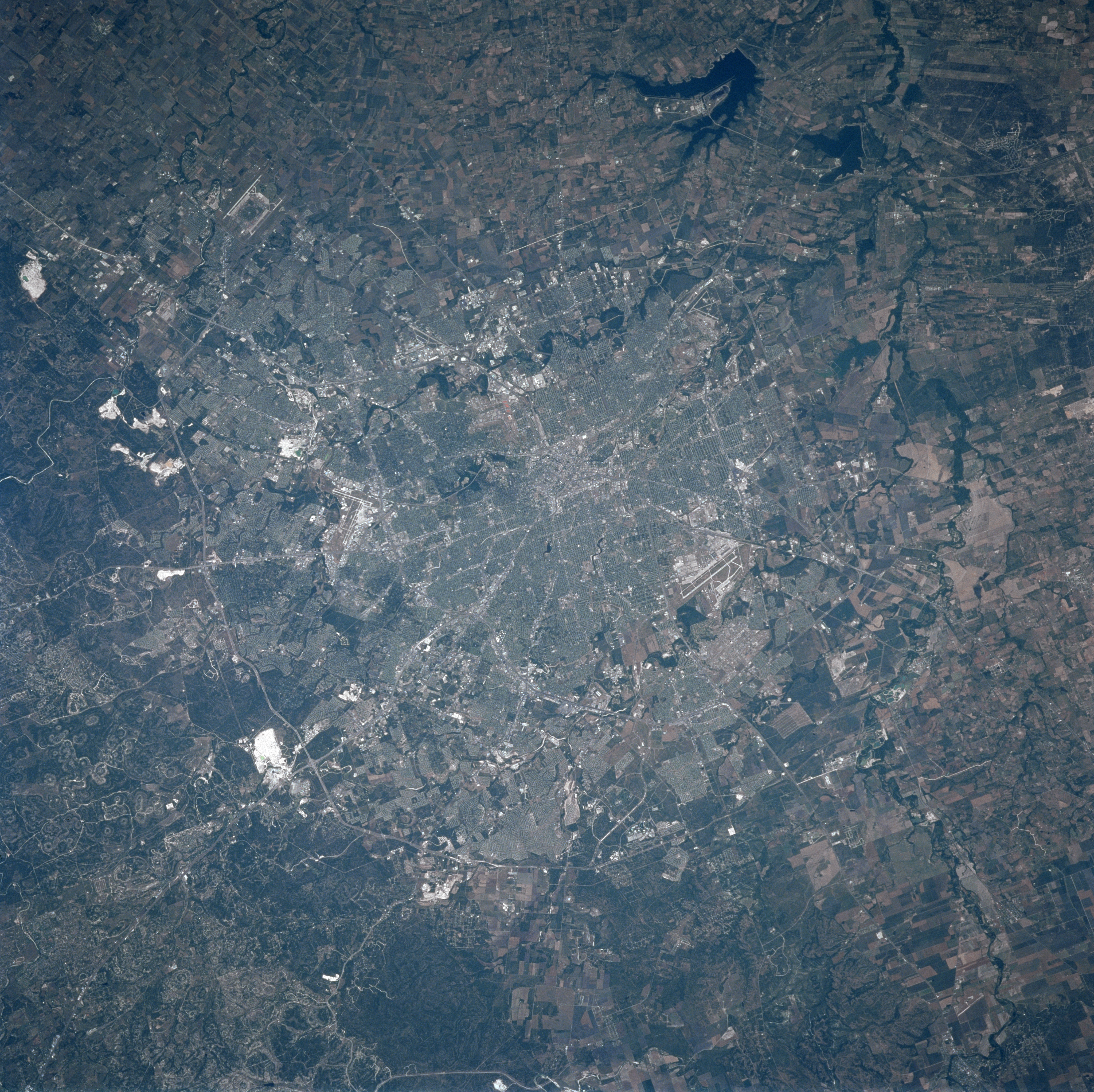
Image Caption: STS090-732-073 San Antonio, Texas, USA April 1998
Downtown San Antonio, or the central business district (highly reflective area), is located near the center of the picture where numerous highways seemingly converge. Parts of the inner loop (Interstate Highway 410) and the outer beltway (Texas Highway 1604) are visible, as they partially encircle the built up urban area (mainly along the north side of San Antonio). The highly reflective white patches north of Texas Highway 1604 are areas where limestone has been quarried as aggregate for highway construction. Three reservoirs, (Calaveras, Brauning, and Mitchell) are visible (dark, irregular shaped features) southeast of downtown San Antonio. The linear runways of Randolph Air Force Base ("H" shape northeast of city), Kelley Air Force Base (southwest of city), and San Antonio International Airport (north of downtown) can be identified. The river channels, (Salada, San Antonio, and Leon Rivers) can be detected as meandering, dark features that eventually merge with the Medina River south of San Antonio. Cultivated field patterns are seen west and south of the city.
Downtown San Antonio, or the central business district (highly reflective area), is located near the center of the picture where numerous highways seemingly converge. Parts of the inner loop (Interstate Highway 410) and the outer beltway (Texas Highway 1604) are visible, as they partially encircle the built up urban area (mainly along the north side of San Antonio). The highly reflective white patches north of Texas Highway 1604 are areas where limestone has been quarried as aggregate for highway construction. Three reservoirs, (Calaveras, Brauning, and Mitchell) are visible (dark, irregular shaped features) southeast of downtown San Antonio. The linear runways of Randolph Air Force Base ("H" shape northeast of city), Kelley Air Force Base (southwest of city), and San Antonio International Airport (north of downtown) can be identified. The river channels, (Salada, San Antonio, and Leon Rivers) can be detected as meandering, dark features that eventually merge with the Medina River south of San Antonio. Cultivated field patterns are seen west and south of the city.
