STS090-727-A

| NASA Photo ID | STS090-727-A |
| Focal Length | 250mm |
| Date taken | 1998.__.__ |
| Time taken | GMT |
Resolutions offered for this image:
4031 x 4085 pixels 631 x 640 pixels 504 x 493 pixels 480 x 478 pixels
4031 x 4085 pixels 631 x 640 pixels 504 x 493 pixels 480 x 478 pixels
Cloud masks available for this image:
Spacecraft nadir point:
Photo center point: 38.0° N, 122.5° W
Photo center point by machine learning:
Photo center point: 38.0° N, 122.5° W
Photo center point by machine learning:
Nadir to Photo Center:
Spacecraft Altitude: nautical miles (0km)
Country or Geographic Name: | USA-CALIFORNIA |
Features: | SAN FRANCISCO BAY, SED. |
| Features Found Using Machine Learning: | |
Cloud Cover Percentage: | 0 (no clouds present) |
Sun Elevation Angle: | ° |
Sun Azimuth: | ° |
Camera: | Hasselblad |
Focal Length: | 250mm |
Camera Tilt: | Near Vertical |
Format: | 5069: Kodak Elite 100S, E6 Reversal, Replaces Lumiere, Warmer in tone vs. Lumiere |
Film Exposure: | Out of Focus |
| Additional Information | |
| Width | Height | Annotated | Cropped | Purpose | Links |
|---|---|---|---|---|---|
| 4031 pixels | 4085 pixels | No | No | Earth From Space collection | Download Image |
| 631 pixels | 640 pixels | No | No | Earth From Space collection | Download Image |
| 504 pixels | 493 pixels | No | No | Download Image | |
| 480 pixels | 478 pixels | Download Image |
Download Packaged File
Download a Google Earth KML for this Image
View photo footprint information
Download a GeoTIFF for this photo
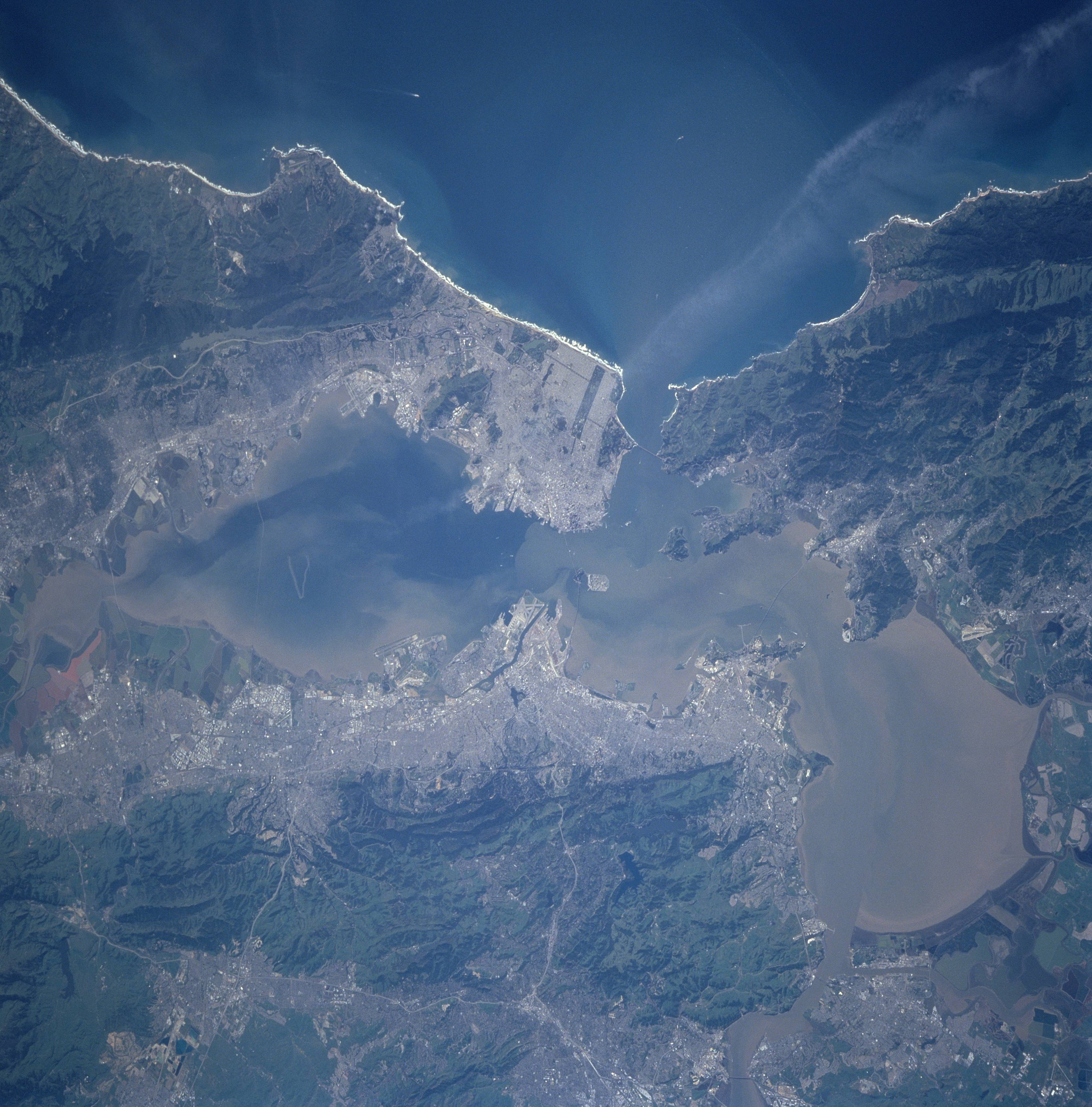
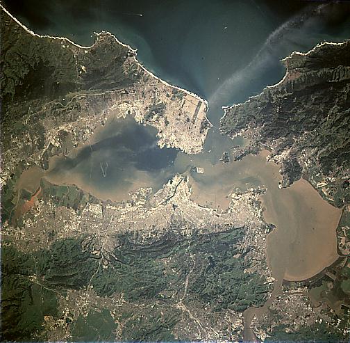
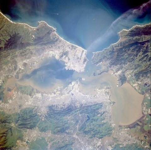
Image Caption: STS090-727-00A San Francisco Bay Area, California, USA April 1998
The conurbation that almost encircles San Francisco Bay (south) and San Pablo Bay (north) clearly contrasts with the rugged, vegetated hills and low mountains around the bays. Several highways (thin, light-colored lines) can be traced through the lower elevations of the vegetated hills east of Berkeley, Oakland, and Hayward along the east side of San Francisco Bay. These highways serve Concord, Walnut Creek, and other cities in the valley corridor east of the hills. Four major bridges (Golden Gate, San Francisco-Oakland Bay, San Mateo, and Dumbarton) that connect the various cities around the bay area are visible. Treasure Island, Golden Gate Park, and salt ponds northeast of San Jose are also visible. There appears to be more sediment (light color) in San Pablo Bay than in San Francisco Bay. Notice that sediment in San Francisco Bay is concentrated along the shoreline, especially south of Oakland. Montara Mountain is the very dark, heavily forested region south of San Francisco and a small segment of the San Andreas Fault is visible along the eastern margin of the mountain.
The conurbation that almost encircles San Francisco Bay (south) and San Pablo Bay (north) clearly contrasts with the rugged, vegetated hills and low mountains around the bays. Several highways (thin, light-colored lines) can be traced through the lower elevations of the vegetated hills east of Berkeley, Oakland, and Hayward along the east side of San Francisco Bay. These highways serve Concord, Walnut Creek, and other cities in the valley corridor east of the hills. Four major bridges (Golden Gate, San Francisco-Oakland Bay, San Mateo, and Dumbarton) that connect the various cities around the bay area are visible. Treasure Island, Golden Gate Park, and salt ponds northeast of San Jose are also visible. There appears to be more sediment (light color) in San Pablo Bay than in San Francisco Bay. Notice that sediment in San Francisco Bay is concentrated along the shoreline, especially south of Oakland. Montara Mountain is the very dark, heavily forested region south of San Francisco and a small segment of the San Andreas Fault is visible along the eastern margin of the mountain.
