STS090-721-55

| NASA Photo ID | STS090-721-55 |
| Focal Length | 100mm |
| Date taken | 1998.04.28 |
| Time taken | 19:21:00 GMT |
Resolutions offered for this image:
4091 x 4055 pixels 640 x 634 pixels 507 x 508 pixels 479 x 479 pixels 518 x 507 pixels
4091 x 4055 pixels 640 x 634 pixels 507 x 508 pixels 479 x 479 pixels 518 x 507 pixels
Cloud masks available for this image:
Spacecraft nadir point: 37.7° N, 113.3° W
Photo center point: 37.0° N, 113.5° W
Photo center point by machine learning:
Photo center point: 37.0° N, 113.5° W
Photo center point by machine learning:
Nadir to Photo Center: South
Spacecraft Altitude: 131 nautical miles (243km)
Country or Geographic Name: | USA-UTAH |
Features: | ST. GEORGE, HURRICANE |
| Features Found Using Machine Learning: | |
Cloud Cover Percentage: | 10 (1-10)% |
Sun Elevation Angle: | 67° |
Sun Azimuth: | 174° |
Camera: | Hasselblad |
Focal Length: | 100mm |
Camera Tilt: | 18 degrees |
Format: | 5069: Kodak Elite 100S, E6 Reversal, Replaces Lumiere, Warmer in tone vs. Lumiere |
Film Exposure: | Normal |
| Additional Information | |
| Width | Height | Annotated | Cropped | Purpose | Links |
|---|---|---|---|---|---|
| 4091 pixels | 4055 pixels | No | No | Earth From Space collection | Download Image |
| 640 pixels | 634 pixels | No | No | Earth From Space collection | Download Image |
| 507 pixels | 508 pixels | Earth From Space phase 2 | Download Image | ||
| 479 pixels | 479 pixels | Download Image | |||
| 518 pixels | 507 pixels | No | No | Download Image |
Download Packaged File
Download a Google Earth KML for this Image
View photo footprint information
Download a GeoTIFF for this photo
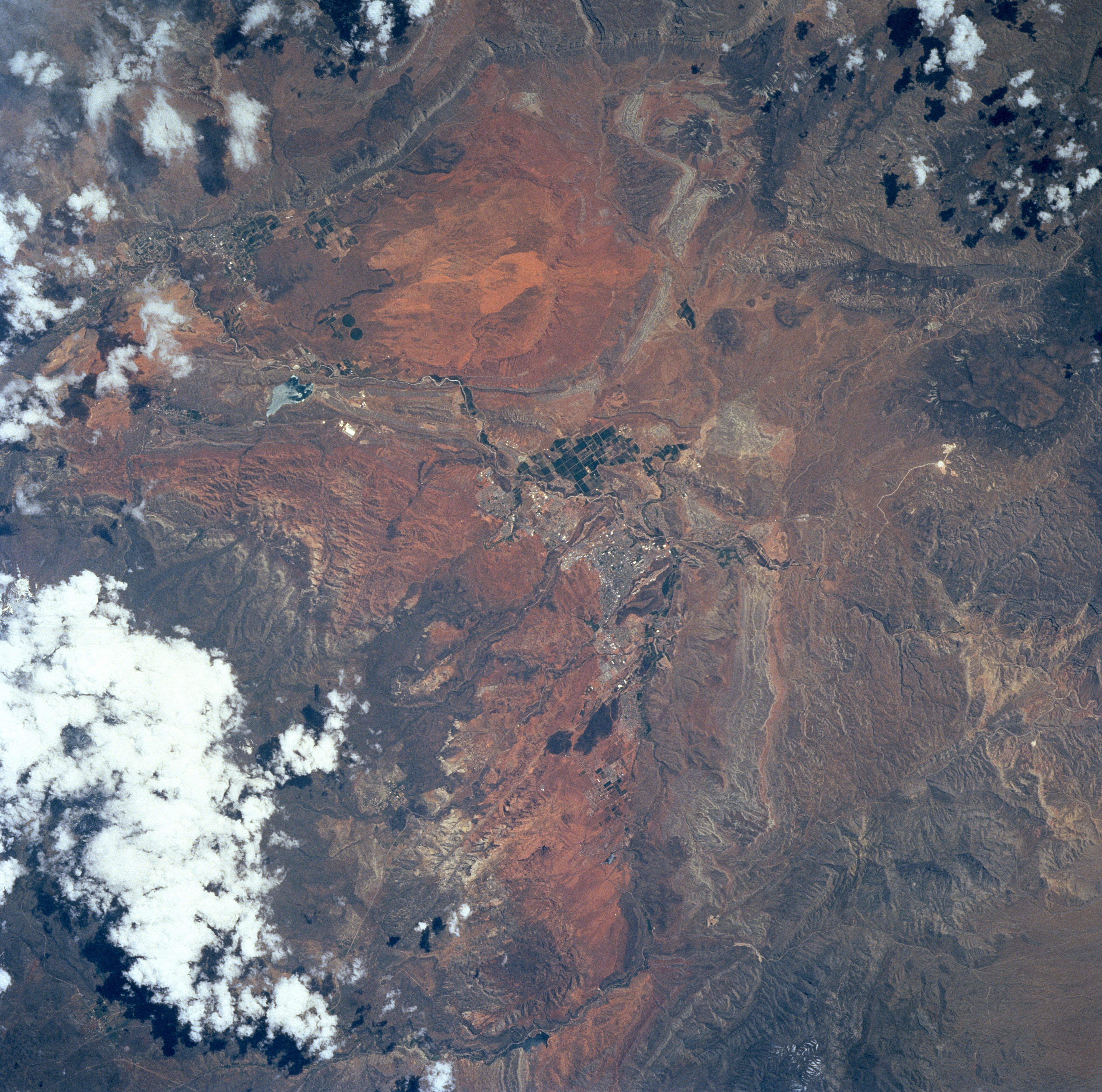
Image Caption: STS090-721-055 Saint George, Utah April 1998
At the center of this near-vertical view is the city of Saint George in the desert of southwestern Utah. The town is in the Virgin River valley, about 60 miles northeast of Lake Mead. Saint George is a tourist center for southern Utah's national parks such as Zion, Bryce Canyon, and Cedar Breaks. The city was founded in 1861 by Mormons and named "Dixie" because the area was a center for growing and processing cotton. Saint George is a growing "sun-belt" retirement community. The small town of Hurricane, north-northeast of Saint George, is discernible in the break in the clouds at upper left of the image. Quail Creek Reservoir is also visible northeast of St. George.
At the center of this near-vertical view is the city of Saint George in the desert of southwestern Utah. The town is in the Virgin River valley, about 60 miles northeast of Lake Mead. Saint George is a tourist center for southern Utah's national parks such as Zion, Bryce Canyon, and Cedar Breaks. The city was founded in 1861 by Mormons and named "Dixie" because the area was a center for growing and processing cotton. Saint George is a growing "sun-belt" retirement community. The small town of Hurricane, north-northeast of Saint George, is discernible in the break in the clouds at upper left of the image. Quail Creek Reservoir is also visible northeast of St. George.
