STS090-714-74

| NASA Photo ID | STS090-714-74 |
| Focal Length | 250mm |
| Date taken | 1998.__.__ |
| Time taken | GMT |
Cloud masks available for this image:
Spacecraft nadir point:
Photo center point: 39.5° N, 3.0° E
Photo center point by machine learning:
Photo center point: 39.5° N, 3.0° E
Photo center point by machine learning:
Nadir to Photo Center:
Spacecraft Altitude: nautical miles (0km)
Country or Geographic Name: | BALEARIC ISLANDS |
Features: | MALLORCA, PALMA, B. ALCUDIA |
| Features Found Using Machine Learning: | |
Cloud Cover Percentage: | 0 (no clouds present) |
Sun Elevation Angle: | ° |
Sun Azimuth: | ° |
Camera: | Hasselblad |
Focal Length: | 250mm |
Camera Tilt: | Low Oblique |
Format: | 5069: Kodak Elite 100S, E6 Reversal, Replaces Lumiere, Warmer in tone vs. Lumiere |
Film Exposure: | Normal |
| Additional Information | |
| Width | Height | Annotated | Cropped | Purpose | Links |
|---|---|---|---|---|---|
| 4060 pixels | 4060 pixels | No | No | Earth From Space collection | Download Image |
| 639 pixels | 639 pixels | No | No | Earth From Space collection | Download Image |
Download Packaged File
Download a Google Earth KML for this Image
View photo footprint information
Download a GeoTIFF for this photo
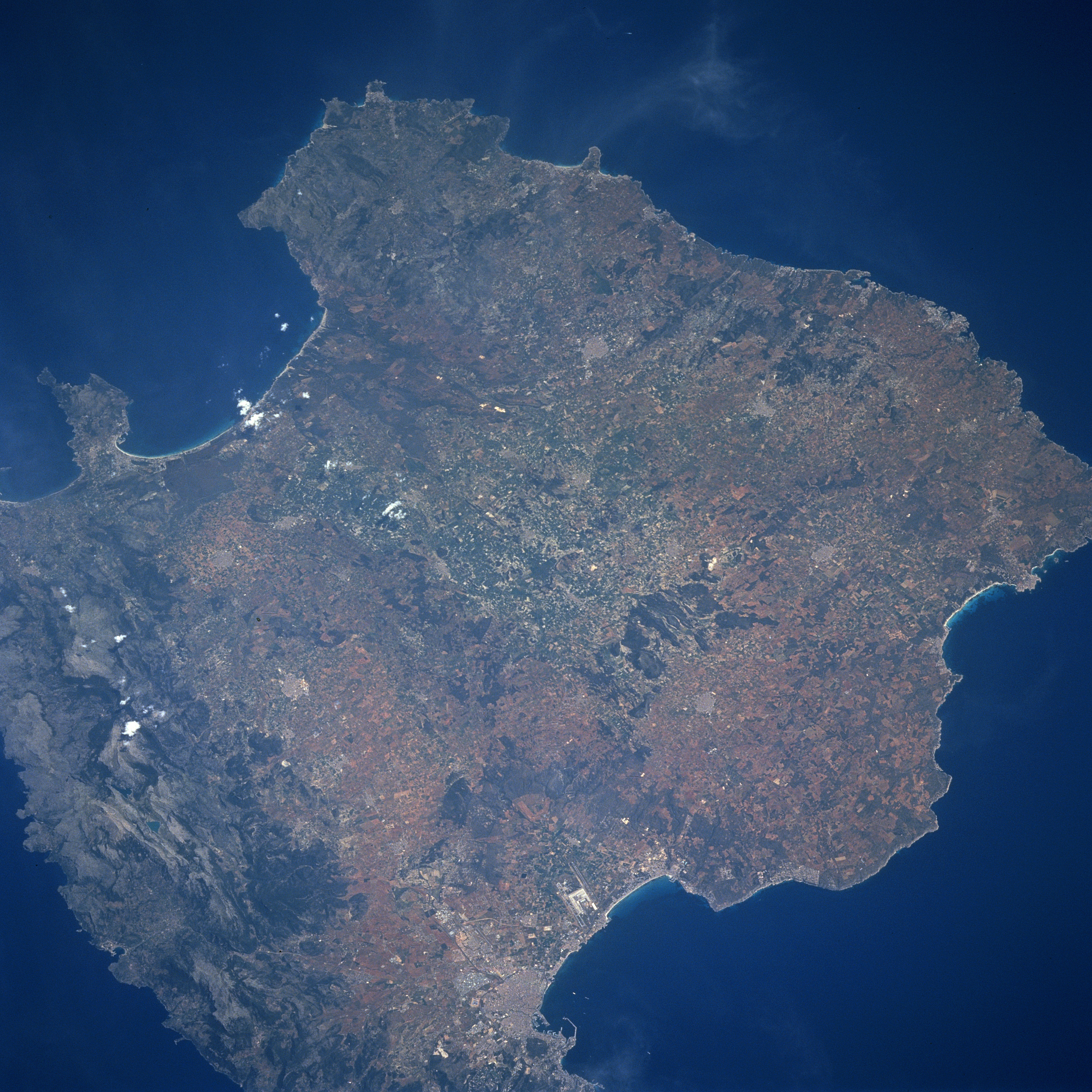
Image Caption: STS090-714-074 Mallorca, Balearic Islands, Spain April 1998
Mallorca, the largest of the Balearic Arcihpelago (1405 square miles-3640 sq. km), which is located in the Mediterranean Sea east of Spain, is a natural bridge between the smaller islands of Menorca (northeast) and Ibiza (southwest). This chain of islands, popular tourist destinations, represent a continuation of the Sierra Nevada mountains of southern Spain which are part of the much larger Alpine system found throughout southern Europe. The Sierra De Tramontana, the most easily recognized mountain range on Mallorca, parallels the entire northwest coast of the island (center of image) and along the east, southwest coast. The rural landscape includes olive and almond trees, as well as strands of pine, fruit, and evergreen oak trees. Approximately half of the islands 650000 people live in he capital city of Polma. Polma is visible in this picture along the northern edge of the Bay of Polma (bottom-center). The two parallel runways (light colored, linear feature) of the busy Polma airport are visible immediately south of the city.
Mallorca, the largest of the Balearic Arcihpelago (1405 square miles-3640 sq. km), which is located in the Mediterranean Sea east of Spain, is a natural bridge between the smaller islands of Menorca (northeast) and Ibiza (southwest). This chain of islands, popular tourist destinations, represent a continuation of the Sierra Nevada mountains of southern Spain which are part of the much larger Alpine system found throughout southern Europe. The Sierra De Tramontana, the most easily recognized mountain range on Mallorca, parallels the entire northwest coast of the island (center of image) and along the east, southwest coast. The rural landscape includes olive and almond trees, as well as strands of pine, fruit, and evergreen oak trees. Approximately half of the islands 650000 people live in he capital city of Polma. Polma is visible in this picture along the northern edge of the Bay of Polma (bottom-center). The two parallel runways (light colored, linear feature) of the busy Polma airport are visible immediately south of the city.
