STS090-712-58
| NASA Photo ID | STS090-712-58 |
| Focal Length | 250mm |
| Date taken | 1998.04.25 |
| Time taken | 18:05:26 GMT |
Resolutions offered for this image:
3994 x 3994 pixels 640 x 640 pixels 482 x 513 pixels 479 x 478 pixels
3994 x 3994 pixels 640 x 640 pixels 482 x 513 pixels 479 x 478 pixels


Cloud masks available for this image:
Spacecraft nadir point: 38.5° N, 76.6° W
Photo center point: 37.0° N, 76.0° W
Photo center point by machine learning:
Photo center point: 37.0° N, 76.0° W
Photo center point by machine learning:
Nadir to Photo Center: South
Spacecraft Altitude: 133 nautical miles (246km)
Country or Geographic Name: | USA-VIRGINIA |
Features: | NORKOLK, NEWPORT NEWS |
| Features Found Using Machine Learning: | |
Cloud Cover Percentage: | 5 (1-10)% |
Sun Elevation Angle: | 62° |
Sun Azimuth: | 212° |
Camera: | Hasselblad |
Focal Length: | 250mm |
Camera Tilt: | 36 degrees |
Format: | 5069: Kodak Elite 100S, E6 Reversal, Replaces Lumiere, Warmer in tone vs. Lumiere |
Film Exposure: | Normal |
| Additional Information | |
| Width | Height | Annotated | Cropped | Purpose | Links |
|---|---|---|---|---|---|
| 3994 pixels | 3994 pixels | No | No | Earth From Space collection | Download Image |
| 640 pixels | 640 pixels | No | No | Earth From Space collection | Download Image |
| 482 pixels | 513 pixels | No | No | Download Image | |
| 479 pixels | 478 pixels | Download Image |
Download Packaged File
Download a Google Earth KML for this Image
View photo footprint information
Download a GeoTIFF for this photo
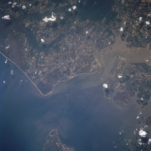
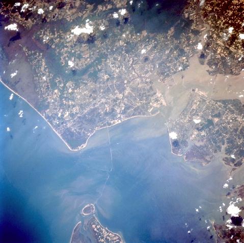
Image Caption: STS090-712-058 Chesapeake Bay, Norfolk, Virginia April 1998
The entrance into Chesapeake Bay and the Norfolk Metropolitan area can be seen in this south-southwest-looking view. The southern tip of the Delmarva Peninsula and Cape Charles are visible near the bottom center of the image. The 18 mile (29 km) Chesapeake Bay Bridge-Tunnel complex traverses across Chesapeake Bay to just east of Norfolk. Cape Henry is visible to the bridge's east (left). Norfolk, Virginia's second largest city is bordered to the north by the Chesapeake Bay, to the northwest by Hampton Roads Harbor, and to the south-southwest by the Great Dismal Swamp (dark area towards the upper right). The city is the business, commercial, financial, cultural, and medical center of this region. Nearly two-thirds of the U.S. population lives within 750 miles (1208 km) of Norfolk. Norfolk's Harbor is called Hampton Roads and it is located where Chesapeake Bay, Elizabeth River, James River, and the Nansemond River meet. Hampton Roads is one of the largest, naturally deep, ice-free harbors in the world. The port traditionally handles more foreign waterborne commerce than any other United States port facility. Norfolk is also home to the largest Naval installation in the world.
The entrance into Chesapeake Bay and the Norfolk Metropolitan area can be seen in this south-southwest-looking view. The southern tip of the Delmarva Peninsula and Cape Charles are visible near the bottom center of the image. The 18 mile (29 km) Chesapeake Bay Bridge-Tunnel complex traverses across Chesapeake Bay to just east of Norfolk. Cape Henry is visible to the bridge's east (left). Norfolk, Virginia's second largest city is bordered to the north by the Chesapeake Bay, to the northwest by Hampton Roads Harbor, and to the south-southwest by the Great Dismal Swamp (dark area towards the upper right). The city is the business, commercial, financial, cultural, and medical center of this region. Nearly two-thirds of the U.S. population lives within 750 miles (1208 km) of Norfolk. Norfolk's Harbor is called Hampton Roads and it is located where Chesapeake Bay, Elizabeth River, James River, and the Nansemond River meet. Hampton Roads is one of the largest, naturally deep, ice-free harbors in the world. The port traditionally handles more foreign waterborne commerce than any other United States port facility. Norfolk is also home to the largest Naval installation in the world.
