STS090-705-93

| NASA Photo ID | STS090-705-93 |
| Focal Length | 250mm |
| Date taken | 1998.04.18 |
| Time taken | 21:23:59 GMT |
Resolutions offered for this image:
4049 x 4091 pixels 633 x 640 pixels 517 x 524 pixels 479 x 479 pixels
4049 x 4091 pixels 633 x 640 pixels 517 x 524 pixels 479 x 479 pixels

Cloud masks available for this image:
Spacecraft nadir point: 34.8° N, 117.6° W
Photo center point: 32.5° N, 117.0° W
Photo center point by machine learning:
Photo center point: 32.5° N, 117.0° W
Photo center point by machine learning:
Nadir to Photo Center: South
Spacecraft Altitude: 138 nautical miles (256km)
Country or Geographic Name: | USA-CALIFORNIA |
Features: | SAN DIEGO, LAGUNA MTS. |
| Features Found Using Machine Learning: | |
Cloud Cover Percentage: | 0 (no clouds present) |
Sun Elevation Angle: | 58° |
Sun Azimuth: | 228° |
Camera: | Hasselblad |
Focal Length: | 250mm |
Camera Tilt: | 46 degrees |
Format: | 5069: Kodak Elite 100S, E6 Reversal, Replaces Lumiere, Warmer in tone vs. Lumiere |
Film Exposure: | Normal |
| Additional Information | |
| Width | Height | Annotated | Cropped | Purpose | Links |
|---|---|---|---|---|---|
| 4049 pixels | 4091 pixels | No | No | Earth From Space collection | Download Image |
| 633 pixels | 640 pixels | No | No | Earth From Space collection | Download Image |
| 517 pixels | 524 pixels | No | No | Download Image | |
| 479 pixels | 479 pixels | Download Image |
Download Packaged File
Download a Google Earth KML for this Image
View photo footprint information
Download a GeoTIFF for this photo
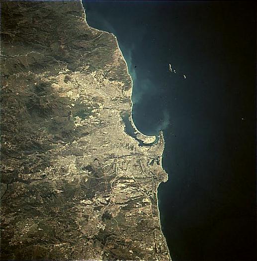
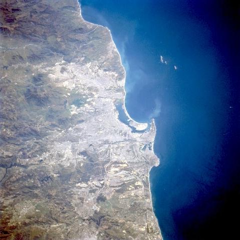
Image Caption: STS090-705-093 San Diego Area, California, USA April 1998
The small scale of this image that includes San Diego (CA) and Tijuana (Mexico) allows the viewer to see the relationship of these two growing urban areas with regard to each other and also to the mountainous terrain south and east that effects their growth pattern. Three major colors in this picture reflect three distinct features: the lighter colored areas show the distribution of a human modified environment (urban, built-up); the darker land shows mountainous terrain (only sparsely populated); and the deep blue color of the Pacific Ocean. While it is difficult in general to identify specific urban infrastructure within these urban areas, segments of Interstate Highways 5, 8, and 15 are visible north, northeast of San Diego. San Diego Bay, the elongated, northwest-southeast oriented body of water is visible near the center of the image. The three small islands, Islas Coronados, off the coast belong to Mexico.
The small scale of this image that includes San Diego (CA) and Tijuana (Mexico) allows the viewer to see the relationship of these two growing urban areas with regard to each other and also to the mountainous terrain south and east that effects their growth pattern. Three major colors in this picture reflect three distinct features: the lighter colored areas show the distribution of a human modified environment (urban, built-up); the darker land shows mountainous terrain (only sparsely populated); and the deep blue color of the Pacific Ocean. While it is difficult in general to identify specific urban infrastructure within these urban areas, segments of Interstate Highways 5, 8, and 15 are visible north, northeast of San Diego. San Diego Bay, the elongated, northwest-southeast oriented body of water is visible near the center of the image. The three small islands, Islas Coronados, off the coast belong to Mexico.
