STS090-705-58
| NASA Photo ID | STS090-705-58 |
| Focal Length | 250mm |
| Date taken | 1998.04.18 |
| Time taken | 13:58:29 GMT |

Cloud masks available for this image:
Spacecraft nadir point: 38.2° N, 12.9° E
Photo center point: 38.0° N, 13.5° E
Photo center point by machine learning:
Photo center point: 38.0° N, 13.5° E
Photo center point by machine learning:
Nadir to Photo Center: East
Spacecraft Altitude: 140 nautical miles (259km)
Camera: | Hasselblad |
Focal Length: | 250mm |
Camera Tilt: | 15 degrees |
Format: | 5069: Kodak Elite 100S, E6 Reversal, Replaces Lumiere, Warmer in tone vs. Lumiere |
Film Exposure: | Normal |
| Additional Information | |
| Width | Height | Annotated | Cropped | Purpose | Links |
|---|---|---|---|---|---|
| 4036 pixels | 4036 pixels | No | No | Earth From Space collection | Download Image |
| 639 pixels | 639 pixels | No | No | Earth From Space collection | Download Image |
Download Packaged File
Download a Google Earth KML for this Image
View photo footprint information
Download a GeoTIFF for this photo
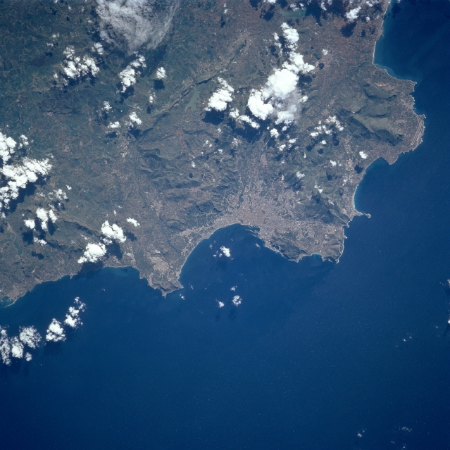
Image Caption: STS090-705-058 Palermo, Sicily, Italy April 1998
Although scattered clouds obscure some of the terrain, the extensiveness of the urban built-up area of Palermo is obvious near the center of the picture. With a population of roughly 700000 people, Palermo is the largest city and chief seaport of Sicily. The topography of this section of northern Sicily consists of the low mountains of the Conca D'Ora Range. The general texture of the land conveys the ruggedness of the surrounding landscape. The city faces a large bay that is part of the Tyrrhenian Sea. Intersecting runways (linear features) of the Palermo Airport are barely visible on the large peninsula west of the city.
Although scattered clouds obscure some of the terrain, the extensiveness of the urban built-up area of Palermo is obvious near the center of the picture. With a population of roughly 700000 people, Palermo is the largest city and chief seaport of Sicily. The topography of this section of northern Sicily consists of the low mountains of the Conca D'Ora Range. The general texture of the land conveys the ruggedness of the surrounding landscape. The city faces a large bay that is part of the Tyrrhenian Sea. Intersecting runways (linear features) of the Palermo Airport are barely visible on the large peninsula west of the city.
