STS089-709-55
| NASA Photo ID | STS089-709-55 |
| Focal Length | 100mm |
| Date taken | 1998.01.30 |
| Time taken | 18:30:00 GMT |

Cloud masks available for this image:
Spacecraft nadir point: 33.8° S, 58.1° W
Photo center point: 34.0° S, 58.5° W
Photo center point by machine learning:
Photo center point: 34.0° S, 58.5° W
Photo center point by machine learning:
Nadir to Photo Center: Southwest
Spacecraft Altitude: 197 nautical miles (365km)
Country or Geographic Name: | ARGENTINA |
Features: | PARANA RIVER |
| Features Found Using Machine Learning: | |
Cloud Cover Percentage: | 5 (1-10)% |
Sun Elevation Angle: | 54° |
Sun Azimuth: | 287° |
Camera: | Hasselblad |
Focal Length: | 100mm |
Camera Tilt: | 8 degrees |
Format: | 5069: Kodak Elite 100S, E6 Reversal, Replaces Lumiere, Warmer in tone vs. Lumiere |
Film Exposure: | Normal |
| Additional Information | |
| Width | Height | Annotated | Cropped | Purpose | Links |
|---|---|---|---|---|---|
| 4096 pixels | 4096 pixels | No | No | Earth From Space collection | Download Image |
| 640 pixels | 640 pixels | No | No | Earth From Space collection | Download Image |
Download Packaged File
Download a Google Earth KML for this Image
View photo footprint information
Download a GeoTIFF for this photo
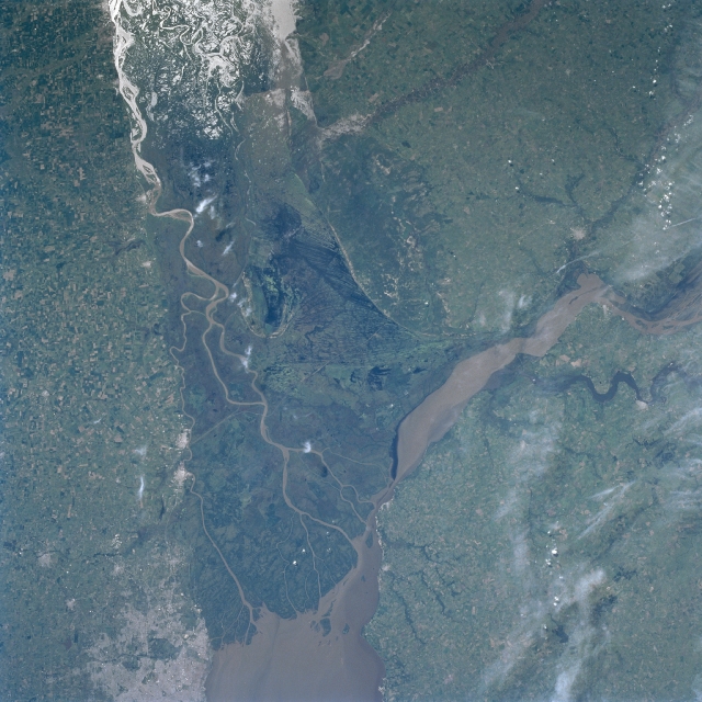
Image Caption: STS089-709-055 Parana River Delta, Argentina January 1997
The Parana River is considered to be one of South America's three great rivers. It has built a large delta complex at the northwest end of the Rio de la Plata estuary. Several sediment laden distributary channels are visible as they wind through the dense vegetation of the broad swath of dark-looking swampland that is the delta area. The linear features near the center of the image in the mouth of the delta are canals. The flat, intensely cultivated landscape that surrounds the large delta includes extensive grasslands. A variety of crops, such as, alfalfa, wheat, sorghum, corn (maize), and sunflowers are grown throughout this humid temperate climate. The bright area along the top of the picture is the sun's reflection off open water. It is called sunglint or sun glitter. The sunglint enables the viewer to see the complexity of the drainage pattern, the extent of wetlands, and the flood-plain boundaries for this part of the Parana River. The lighter colored area along the lower left margin of the picture is western Buenos Aires. The muddy-looking Uruguay River also flows into the northwest corner of the Rio de la Plata.
The Parana River is considered to be one of South America's three great rivers. It has built a large delta complex at the northwest end of the Rio de la Plata estuary. Several sediment laden distributary channels are visible as they wind through the dense vegetation of the broad swath of dark-looking swampland that is the delta area. The linear features near the center of the image in the mouth of the delta are canals. The flat, intensely cultivated landscape that surrounds the large delta includes extensive grasslands. A variety of crops, such as, alfalfa, wheat, sorghum, corn (maize), and sunflowers are grown throughout this humid temperate climate. The bright area along the top of the picture is the sun's reflection off open water. It is called sunglint or sun glitter. The sunglint enables the viewer to see the complexity of the drainage pattern, the extent of wetlands, and the flood-plain boundaries for this part of the Parana River. The lighter colored area along the lower left margin of the picture is western Buenos Aires. The muddy-looking Uruguay River also flows into the northwest corner of the Rio de la Plata.
