STS087-768-79
| NASA Photo ID | STS087-768-79 |
| Focal Length | 100mm |
| Date taken | 1997.12.01 |
| Time taken | 04:55:32 GMT |

Cloud masks available for this image:
Spacecraft nadir point: 15.8° N, 104.8° E
Photo center point: 16.5° N, 103.5° E
Photo center point by machine learning:
Photo center point: 16.5° N, 103.5° E
Photo center point by machine learning:
Nadir to Photo Center: Northwest
Spacecraft Altitude: 150 nautical miles (278km)
Country or Geographic Name: | THAILAND |
Features: | LAM POO RESERVOIR |
| Features Found Using Machine Learning: | |
Cloud Cover Percentage: | 5 (1-10)% |
Sun Elevation Angle: | 52° |
Sun Azimuth: | 182° |
Camera: | Hasselblad |
Focal Length: | 100mm |
Camera Tilt: | 31 degrees |
Format: | 5069: Kodak Elite 100S, E6 Reversal, Replaces Lumiere, Warmer in tone vs. Lumiere |
Film Exposure: | Normal |
| Additional Information | |
| Width | Height | Annotated | Cropped | Purpose | Links |
|---|---|---|---|---|---|
| 4096 pixels | 4096 pixels | No | No | Earth From Space collection | Download Image |
| 640 pixels | 640 pixels | No | No | Earth From Space collection | Download Image |
| 642 pixels | 642 pixels | No | No | Download Image |
Download Packaged File
Download a Google Earth KML for this Image
View photo footprint information
Download a GeoTIFF for this photo
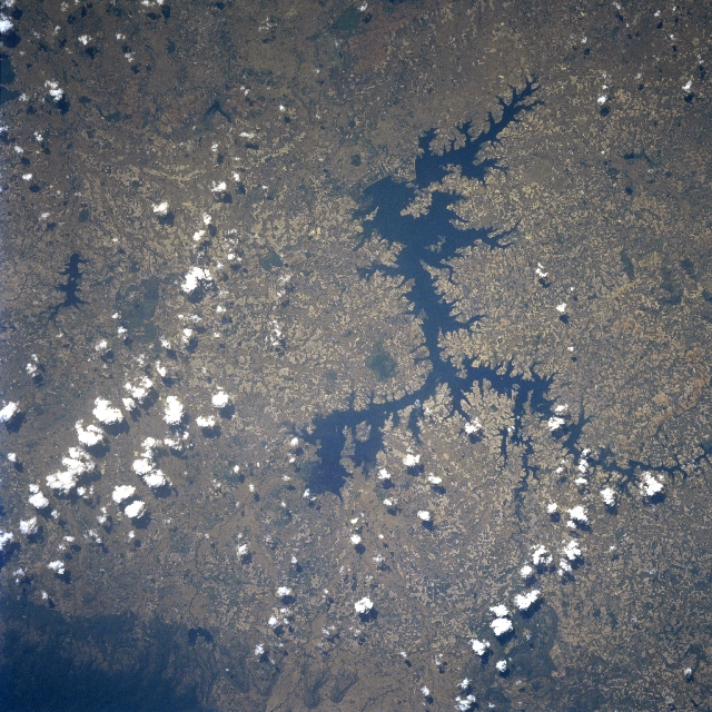
Image Caption: STS087-768-079 Lam Pao (Reservoir), Thailand November 1997
The Lam Pao, irregular-shaped reservoir (dark feature) near the center of the image is located on the Khorat Plateau in northeast Thailand. Although the Lam Pao Dam generates some hydroelectric power, the reservoir's primary function is to serve as a watershed structure to provide water for irrigation to the intensively cultivated farms throughout the region. The dam that is largest earth fill dam in Thailand (approximately 5 miles-8 km in length) is located along the southeast end of the reservoir. As a result of an improving water utilization plan in this region, many farmers can produce two crops of rice per year from the same fields (double cropping).
The Lam Pao, irregular-shaped reservoir (dark feature) near the center of the image is located on the Khorat Plateau in northeast Thailand. Although the Lam Pao Dam generates some hydroelectric power, the reservoir's primary function is to serve as a watershed structure to provide water for irrigation to the intensively cultivated farms throughout the region. The dam that is largest earth fill dam in Thailand (approximately 5 miles-8 km in length) is located along the southeast end of the reservoir. As a result of an improving water utilization plan in this region, many farmers can produce two crops of rice per year from the same fields (double cropping).
