STS087-713-1
| NASA Photo ID | STS087-713-1 |
| Focal Length | 50mm |
| Date taken | 1997.11.29 |
| Time taken | 03:14:17 GMT |
Cloud masks available for this image:
Spacecraft nadir point: 28.6° N, 89.5° E
Photo center point: 28.5° N, 90.5° E
Photo center point by machine learning:
Photo center point: 28.5° N, 90.5° E
Photo center point by machine learning:
Nadir to Photo Center: East
Spacecraft Altitude: 149 nautical miles (276km)
Country or Geographic Name: | CHINA |
Features: | YAMZHO LAKE |
| Features Found Using Machine Learning: | |
Cloud Cover Percentage: | 0 (no clouds present) |
Sun Elevation Angle: | 27° |
Sun Azimuth: | 139° |
Camera: | Hasselblad |
Focal Length: | 50mm |
Camera Tilt: | 22 degrees |
Format: | 5069: Kodak Elite 100S, E6 Reversal, Replaces Lumiere, Warmer in tone vs. Lumiere |
Film Exposure: | Normal |
| Additional Information | |
| Width | Height | Annotated | Cropped | Purpose | Links |
|---|---|---|---|---|---|
| 6828 pixels | 6828 pixels | No | No | Earth From Space collection | Download Image |
| 640 pixels | 640 pixels | No | No | Earth From Space collection | Download Image |
| 639 pixels | 648 pixels | No | No | Download Image |
Download Packaged File
Download a Google Earth KML for this Image
View photo footprint information
Download a GeoTIFF for this photo
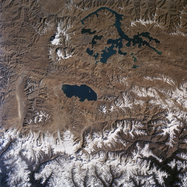
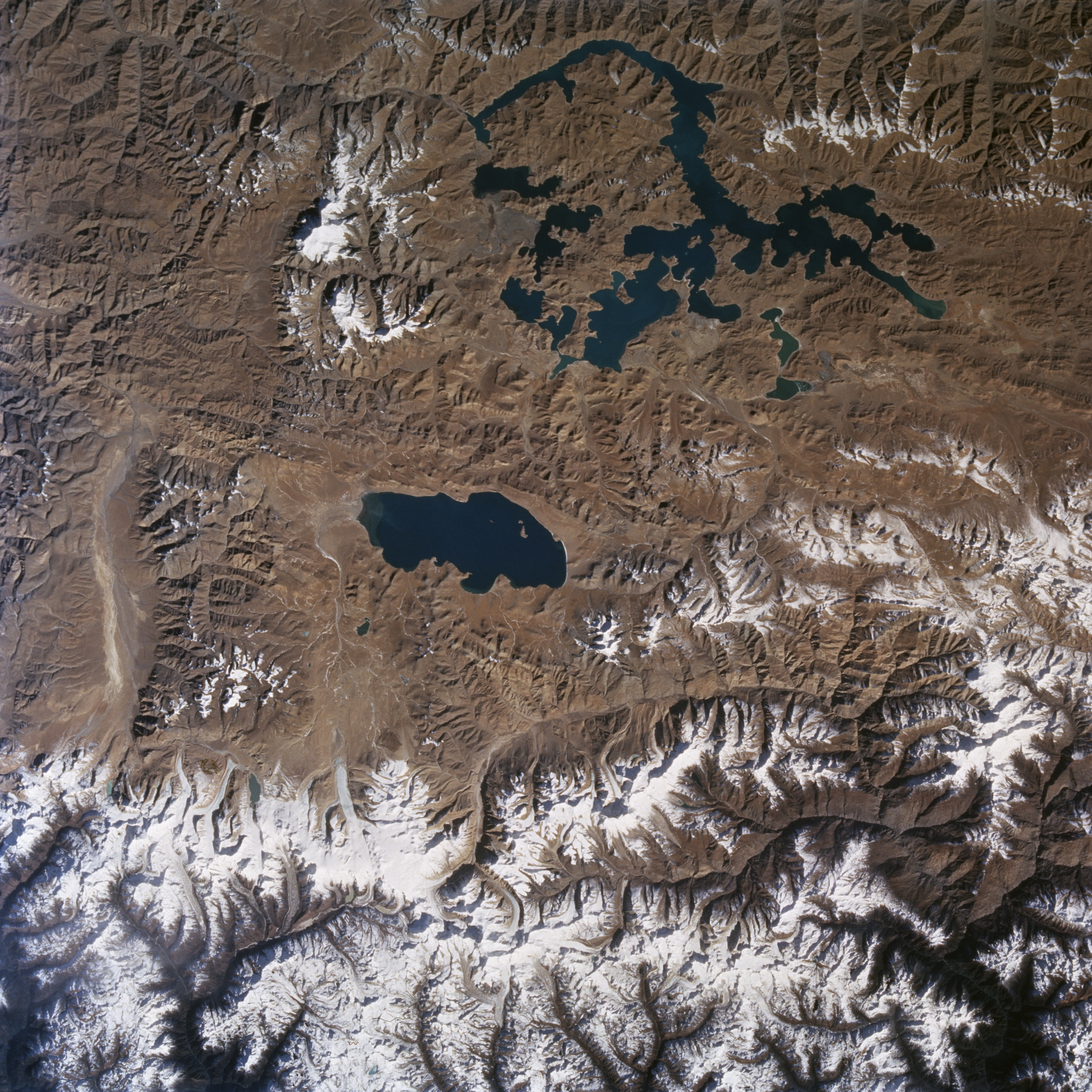
Image Caption: STS087-713-001 Tibetan Lakes, China November 1997
Two distinct lakes (dark features) are clearly visible in this barren, elevated landscape of the Tibetan Plateau north of Bhutan. The surface elevation of the compact-looking lake near the center of the image, Puma Yumco Lake, is 16525 feet (5037 meters) above sea level; while the surface elevation of Yamzho Yumco Lake with its more elongated and complex pattern is 14700 feet (4480 meters). This section of the Chinese Tibetan Plateau is a rugged, sparsely vegetated plateau with practically all of the terrain in this image above 15000 feet (4572 meters) above sea level. An indefinite border that exists between Bhutan (south) and China (north) extends generally east to west across the higher elevations of the snow and ice (glaciers) Himalaya Mountains (bottom). Several peaks in these permanently glaciated mountains exceed 23000 feet (7010 meters). Numerous glaciated river valleys (dark drainage pattern bottom edge) drain southward through northern Bhutan.
Two distinct lakes (dark features) are clearly visible in this barren, elevated landscape of the Tibetan Plateau north of Bhutan. The surface elevation of the compact-looking lake near the center of the image, Puma Yumco Lake, is 16525 feet (5037 meters) above sea level; while the surface elevation of Yamzho Yumco Lake with its more elongated and complex pattern is 14700 feet (4480 meters). This section of the Chinese Tibetan Plateau is a rugged, sparsely vegetated plateau with practically all of the terrain in this image above 15000 feet (4572 meters) above sea level. An indefinite border that exists between Bhutan (south) and China (north) extends generally east to west across the higher elevations of the snow and ice (glaciers) Himalaya Mountains (bottom). Several peaks in these permanently glaciated mountains exceed 23000 feet (7010 meters). Numerous glaciated river valleys (dark drainage pattern bottom edge) drain southward through northern Bhutan.
