STS087-701-40
| NASA Photo ID | STS087-701-40 |
| Focal Length | 100mm |
| Date taken | 1997.11.21 |
| Time taken | 03:07:42 GMT |

Cloud masks available for this image:
Spacecraft nadir point: 17.2° N, 103.7° E
Photo center point: 17.5° N, 104.0° E
Photo center point by machine learning:
Photo center point: 17.5° N, 104.0° E
Photo center point by machine learning:
Nadir to Photo Center: Northeast
Spacecraft Altitude: 151 nautical miles (280km)
Country or Geographic Name: | THAILAND |
Features: | LAKE HAN, MEKONG RIVER |
| Features Found Using Machine Learning: | |
Cloud Cover Percentage: | 0 (no clouds present) |
Sun Elevation Angle: | 45° |
Sun Azimuth: | 144° |
Camera: | Hasselblad |
Focal Length: | 100mm |
Camera Tilt: | 10 degrees |
Format: | 5069: Kodak Elite 100S, E6 Reversal, Replaces Lumiere, Warmer in tone vs. Lumiere |
Film Exposure: | Normal |
| Additional Information | |
| Width | Height | Annotated | Cropped | Purpose | Links |
|---|---|---|---|---|---|
| 4067 pixels | 4096 pixels | No | No | Earth From Space collection | Download Image |
| 635 pixels | 640 pixels | No | No | Earth From Space collection | Download Image |
| 640 pixels | 641 pixels | No | No | Download Image |
Download Packaged File
Download a Google Earth KML for this Image
View photo footprint information
Download a GeoTIFF for this photo
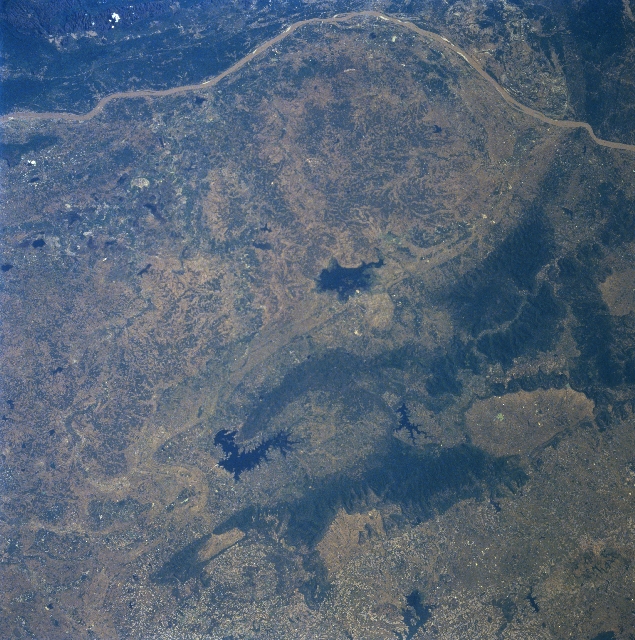
Image Caption: STS087-701-040 Nong Han Lake, Thailand November 1997
A section of the muddy-looking Mekong River (linear, light-colored feature) that runs laterally across the top of the image is the border between Thailand (west of the river) and Laos (land area east of the river). A band of low, forested mountains (dark landscape) with a few maximum elevations barely exceeding 2100 feet (640 meters) above sea level are visible (middle right) as they form a gradual curving structure that crosses the Mekong River into Laos. Several reservoirs (very dark, irregular-shaped features-various sizes), including Nong Han Lake (near center of image), are discernible in the vicinity of the mountainous terrain in the bottom half of the image. Rice is the dominant farm crop that is produced in this region of the Khorat Plateau in northeastern Thailand.
A section of the muddy-looking Mekong River (linear, light-colored feature) that runs laterally across the top of the image is the border between Thailand (west of the river) and Laos (land area east of the river). A band of low, forested mountains (dark landscape) with a few maximum elevations barely exceeding 2100 feet (640 meters) above sea level are visible (middle right) as they form a gradual curving structure that crosses the Mekong River into Laos. Several reservoirs (very dark, irregular-shaped features-various sizes), including Nong Han Lake (near center of image), are discernible in the vicinity of the mountainous terrain in the bottom half of the image. Rice is the dominant farm crop that is produced in this region of the Khorat Plateau in northeastern Thailand.
