STS085-734-85
| NASA Photo ID | STS085-734-85 |
| Focal Length | 100mm |
| Date taken | 1997.08.09 |
| Time taken | 18:03:38 GMT |
Resolutions offered for this image:
4096 x 4085 pixels 640 x 638 pixels 5700 x 5900 pixels 483 x 500 pixels 490 x 508 pixels 479 x 479 pixels
4096 x 4085 pixels 640 x 638 pixels 5700 x 5900 pixels 483 x 500 pixels 490 x 508 pixels 479 x 479 pixels


Cloud masks available for this image:
Spacecraft nadir point: 41.8° N, 127.2° W
Photo center point: 45.5° N, 122.0° W
Photo center point by machine learning:
Photo center point: 45.5° N, 122.0° W
Photo center point by machine learning:
Nadir to Photo Center: Northeast
Spacecraft Altitude: 158 nautical miles (293km)
Country or Geographic Name: | USA-WASHINGTON |
Features: | COLUMBIA RIVER, MT. HOOD |
| Features Found Using Machine Learning: | |
Cloud Cover Percentage: | 5 (1-10)% |
Sun Elevation Angle: | 49° |
Sun Azimuth: | 117° |
Camera: | Hasselblad |
Focal Length: | 100mm |
Camera Tilt: | Low Oblique |
Format: | 5069: Kodak Elite 100S, E6 Reversal, Replaces Lumiere, Warmer in tone vs. Lumiere |
Film Exposure: | Normal |
| Additional Information | |
| Width | Height | Annotated | Cropped | Purpose | Links |
|---|---|---|---|---|---|
| 4096 pixels | 4085 pixels | No | No | Earth From Space collection | Download Image |
| 640 pixels | 638 pixels | No | No | Earth From Space collection | Download Image |
| 5700 pixels | 5900 pixels | No | No | Download Image | |
| 483 pixels | 500 pixels | No | No | Download Image | |
| 490 pixels | 508 pixels | No | No | Download Image | |
| 479 pixels | 479 pixels | Download Image |
Download Packaged File
Download a Google Earth KML for this Image
View photo footprint information
Download a GeoTIFF for this photo
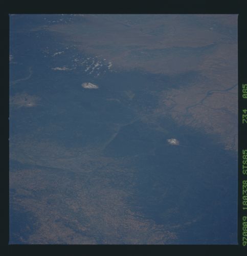
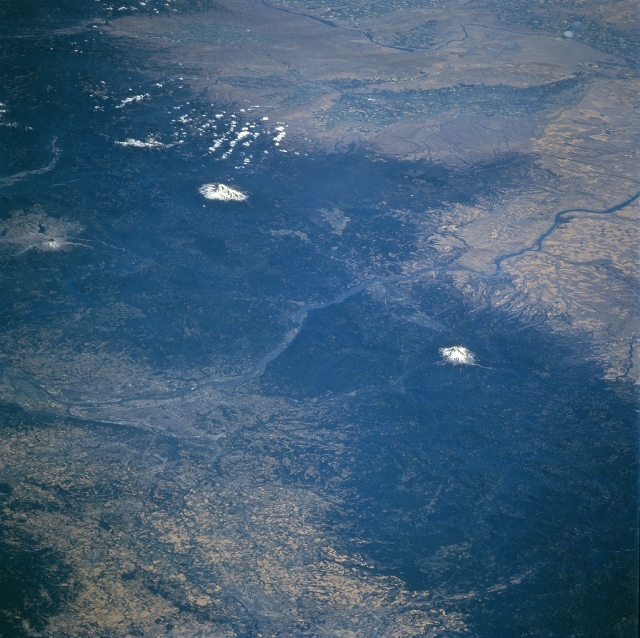
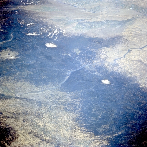
Image Caption: STS085-734-085 Mt. Hood, Oregon and Mt. Adams, Washington, USA August 1997
The two most prominent features in this northeast looking view are the snow-capped summits of Mount Hood (OR) and Mount Adams (WA). At 11,239 feet (3426 meters) and 12325 feet (3757 meters), respectively, these two volcanoes are part of the north-trending Cascade Range. The Cascades provide a formidable meteorological barrier that dramatically reduces precipitation amounts on the leeward or eastern side of the mountains. This rain shadow effect limits farming on the eastern side of the mountains to plateaus and river valleys where adequate supplies of moisture are available. Notice that there are some clusters of cultivated fields in the Yakima and Columbia River Valleys. The Columbia River, (center of view) flows west through the Cascade Mountains. The river forms the boundary between the states of Oregon and Washington. Although not easy to recognize, the city of Portland (OR) can be located along the south side of the Columbia River near the west edge of the picture. South of Portland the fertile northern Willamette River Valley with its multitude of cultivated fields are visible (lighter colors intermixed with darker colors). Mt. St. Helens and its denuded, "blast" zone from the 1980 eruption are also discernible along the western edge of the image north of the Columbia River.
The two most prominent features in this northeast looking view are the snow-capped summits of Mount Hood (OR) and Mount Adams (WA). At 11,239 feet (3426 meters) and 12325 feet (3757 meters), respectively, these two volcanoes are part of the north-trending Cascade Range. The Cascades provide a formidable meteorological barrier that dramatically reduces precipitation amounts on the leeward or eastern side of the mountains. This rain shadow effect limits farming on the eastern side of the mountains to plateaus and river valleys where adequate supplies of moisture are available. Notice that there are some clusters of cultivated fields in the Yakima and Columbia River Valleys. The Columbia River, (center of view) flows west through the Cascade Mountains. The river forms the boundary between the states of Oregon and Washington. Although not easy to recognize, the city of Portland (OR) can be located along the south side of the Columbia River near the west edge of the picture. South of Portland the fertile northern Willamette River Valley with its multitude of cultivated fields are visible (lighter colors intermixed with darker colors). Mt. St. Helens and its denuded, "blast" zone from the 1980 eruption are also discernible along the western edge of the image north of the Columbia River.
