STS085-716-22
| NASA Photo ID | STS085-716-22 |
| Focal Length | 100mm |
| Date taken | 1997.08.11 |
| Time taken | 15:18:12 GMT |
Resolutions offered for this image:
4061 x 4085 pixels 636 x 640 pixels 5700 x 5900 pixels 483 x 500 pixels 503 x 510 pixels 480 x 478 pixels
4061 x 4085 pixels 636 x 640 pixels 5700 x 5900 pixels 483 x 500 pixels 503 x 510 pixels 480 x 478 pixels


Cloud masks available for this image:
Spacecraft nadir point: 51.2° N, 78.2° W
Photo center point: 52.5° N, 80.5° W
Photo center point by machine learning:
Photo center point: 52.5° N, 80.5° W
Photo center point by machine learning:
Nadir to Photo Center: Northwest
Spacecraft Altitude: 156 nautical miles (289km)
Country or Geographic Name: | CANADA-O |
Features: | JAMES BAY, AKIMISKI I. |
| Features Found Using Machine Learning: | |
Cloud Cover Percentage: | 10 (1-10)% |
Sun Elevation Angle: | 47° |
Sun Azimuth: | 135° |
Camera: | Hasselblad |
Focal Length: | 100mm |
Camera Tilt: | 46 degrees |
Format: | 5069: Kodak Elite 100S, E6 Reversal, Replaces Lumiere, Warmer in tone vs. Lumiere |
Film Exposure: | Normal |
| Additional Information | |
| Width | Height | Annotated | Cropped | Purpose | Links |
|---|---|---|---|---|---|
| 4061 pixels | 4085 pixels | No | No | Earth From Space collection | Download Image |
| 636 pixels | 640 pixels | No | No | Earth From Space collection | Download Image |
| 5700 pixels | 5900 pixels | No | No | Download Image | |
| 483 pixels | 500 pixels | No | No | Download Image | |
| 503 pixels | 510 pixels | No | No | Download Image | |
| 480 pixels | 478 pixels | Download Image |
Download Packaged File
Download a Google Earth KML for this Image
View photo footprint information
Download a GeoTIFF for this photo
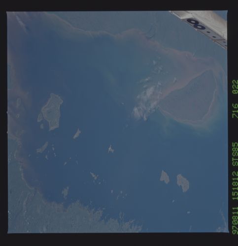
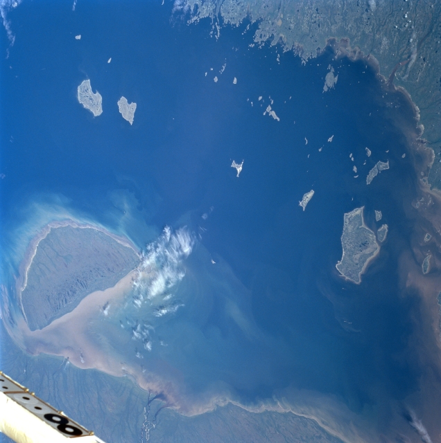
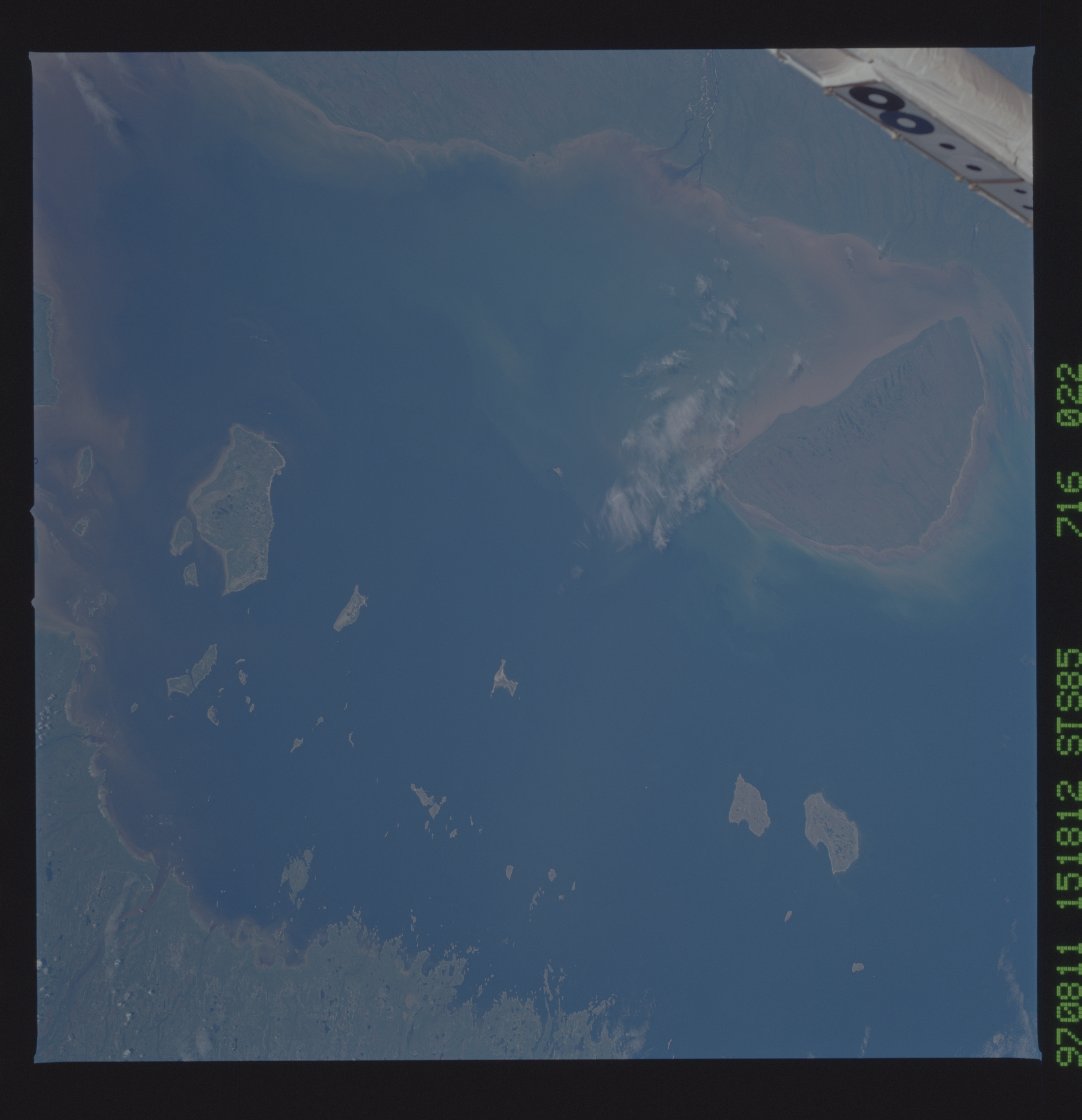
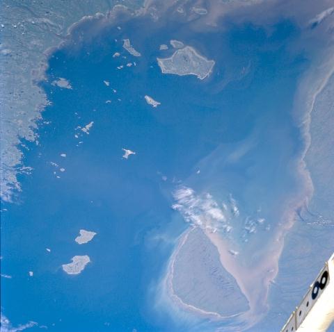
Image Caption: STS085-716-022 James Bay, Quebec/Ontario, Canada August 1997
Most of the southern half of relatively shallow and salty James Bay, a southeastern extension of Hudson Bay, is shown in this southeastward view. Several islands are visible in James Bay between the western shore of Quebec and the eastern coast of Ontario. The larger islands, all uninhabited, include Akimiski Island (largest island --northwest), North and South Twin Islands (northeast), and Charlton Island (south). The islands and the surrounding mainland support numerous species of wildlife. The islands provide suitable habitats for water birds, and the eastern half of Akimiski Island has been designated a migratory bird sanctuary site. During the short summer, when bay waters thaw, fresh water enters saline James Bay carrying sediments and nutrients (lighter-colored water between Akimiski Island and the Ontario shore).
Most of the southern half of relatively shallow and salty James Bay, a southeastern extension of Hudson Bay, is shown in this southeastward view. Several islands are visible in James Bay between the western shore of Quebec and the eastern coast of Ontario. The larger islands, all uninhabited, include Akimiski Island (largest island --northwest), North and South Twin Islands (northeast), and Charlton Island (south). The islands and the surrounding mainland support numerous species of wildlife. The islands provide suitable habitats for water birds, and the eastern half of Akimiski Island has been designated a migratory bird sanctuary site. During the short summer, when bay waters thaw, fresh water enters saline James Bay carrying sediments and nutrients (lighter-colored water between Akimiski Island and the Ontario shore).
