STS085-715-33

| NASA Photo ID | STS085-715-33 |
| Focal Length | 100mm |
| Date taken | 1997.08.11 |
| Time taken | 18:12:50 GMT |
Resolutions offered for this image:
4073 x 4096 pixels 636 x 640 pixels 5700 x 5900 pixels 483 x 500 pixels 2136 x 2476 pixels 515 x 522 pixels 479 x 479 pixels
4073 x 4096 pixels 636 x 640 pixels 5700 x 5900 pixels 483 x 500 pixels 2136 x 2476 pixels 515 x 522 pixels 479 x 479 pixels


Cloud masks available for this image:
Spacecraft nadir point: 36.0° N, 148.1° W
Photo center point: 49.0° N, 123.0° W
Photo center point by machine learning:
Photo center point: 49.0° N, 123.0° W
Photo center point by machine learning:
Nadir to Photo Center: Northeast
Spacecraft Altitude: 156 nautical miles (289km)
Country or Geographic Name: | CANADA-BC |
Features: | PAN-VANCOUVER |
| Features Found Using Machine Learning: | |
Cloud Cover Percentage: | 10 (1-10)% |
Sun Elevation Angle: | 36° |
Sun Azimuth: | 97° |
Camera: | Hasselblad |
Focal Length: | 100mm |
Camera Tilt: | High Oblique |
Format: | 5069: Kodak Elite 100S, E6 Reversal, Replaces Lumiere, Warmer in tone vs. Lumiere |
Film Exposure: | Normal |
| Additional Information | |
| Width | Height | Annotated | Cropped | Purpose | Links |
|---|---|---|---|---|---|
| 4073 pixels | 4096 pixels | No | No | Earth From Space collection | Download Image |
| 636 pixels | 640 pixels | No | No | Earth From Space collection | Download Image |
| 5700 pixels | 5900 pixels | No | No | Download Image | |
| 483 pixels | 500 pixels | No | No | Download Image | |
| 2136 pixels | 2476 pixels | Download Image | |||
| 515 pixels | 522 pixels | No | No | Download Image | |
| 479 pixels | 479 pixels | Download Image |
Download Packaged File
Download a Google Earth KML for this Image
View photo footprint information
Download a GeoTIFF for this photo
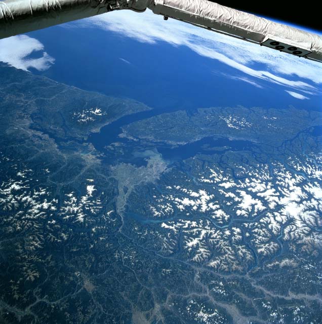
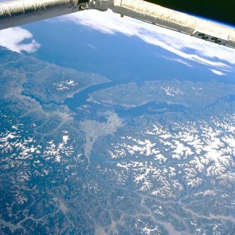
Image Caption: STS085-715-033 Fraser River Valley, British Columbia, Canada August 1997
The Fraser River Valley and its extensive delta (light colored feature) can be observed near the center of the image. A light colored sediment plume can be observed west of Vancouver where the Fraser River empties into the Strait of Georgia (center of picture). The Strait of Georgia separates Vancouver Island from the mainland of British Columbia (Canada). The Juan De Fuca Strait is the other major strait that connects Pudget Sound (U.S.) and the Strait of Georgia with the partially cloud-covered Pacific Ocean (top). Extensive forested slopes and snow covered higher elevations of the Coast Mountains in British Columbia and the northern Cascades in the state of Washington occupy about a third of the picture. There are also limited snow covered peaks in the Olympic Mountains of northwest Washington (top left) and on the central mountains of Vancouver Island, B. C. (top right). A section of the Space Shuttle robotic arm crosses the top of the image.
The Fraser River Valley and its extensive delta (light colored feature) can be observed near the center of the image. A light colored sediment plume can be observed west of Vancouver where the Fraser River empties into the Strait of Georgia (center of picture). The Strait of Georgia separates Vancouver Island from the mainland of British Columbia (Canada). The Juan De Fuca Strait is the other major strait that connects Pudget Sound (U.S.) and the Strait of Georgia with the partially cloud-covered Pacific Ocean (top). Extensive forested slopes and snow covered higher elevations of the Coast Mountains in British Columbia and the northern Cascades in the state of Washington occupy about a third of the picture. There are also limited snow covered peaks in the Olympic Mountains of northwest Washington (top left) and on the central mountains of Vancouver Island, B. C. (top right). A section of the Space Shuttle robotic arm crosses the top of the image.
